Bettviller
| Bettviller | ||
|---|---|---|
| ||
 Bettviller | ||
|
Location within Lorraine region  Bettviller | ||
| Coordinates: 49°04′47″N 7°17′09″E / 49.0797°N 7.2858°ECoordinates: 49°04′47″N 7°17′09″E / 49.0797°N 7.2858°E | ||
| Country | France | |
| Region | Lorraine | |
| Department | Moselle | |
| Arrondissement | Sarreguemines | |
| Canton | Rohrbach-lès-Bitche | |
| Intercommunality | Rohrbach-lès-Bitche | |
| Government | ||
| • Mayor (2008–2014) | Jean-Claude Picard | |
| Area1 | 18.41 km2 (7.11 sq mi) | |
| Population (2009)2 | 838 | |
| • Density | 46/km2 (120/sq mi) | |
| INSEE/Postal code | 57074 / 57410 | |
| Elevation |
252–376 m (827–1,234 ft) (avg. 305 m or 1,001 ft) | |
|
1 French Land Register data, which excludes lakes, ponds, glaciers > 1 km² (0.386 sq mi or 247 acres) and river estuaries. 2 Population without double counting: residents of multiple communes (e.g., students and military personnel) only counted once. | ||
.svg.png)
Bettviller is a commune in the Moselle department in Lorraine in north-astern France.
It is mentioned for the first time in 1157, in the forms "Bedebur" and "Bedeviller" in 1496 (oratory). The current village was built in the 16th century.
Population
| Historical population | ||
|---|---|---|
| Year | Pop. | ±% |
| 1793 | 894 | — |
| 1800 | 811 | −9.3% |
| 1806 | 1,017 | +25.4% |
| 1821 | 1,230 | +20.9% |
| 1836 | 1,110 | −9.8% |
| 1841 | 1,086 | −2.2% |
| 1861 | 1,055 | −2.9% |
| 1866 | 1,072 | +1.6% |
| 1872 | 1,056 | −1.5% |
| 1876 | 1,035 | −2.0% |
| 1881 | 980 | −5.3% |
| 1886 | 936 | −4.5% |
| 1891 | 935 | −0.1% |
| 1896 | 932 | −0.3% |
| 1901 | 939 | +0.8% |
| 1906 | 951 | +1.3% |
| 1911 | 968 | +1.8% |
| 1921 | 972 | +0.4% |
| 1926 | 960 | −1.2% |
| 1931 | 963 | +0.3% |
| 1936 | 946 | −1.8% |
| 1946 | 868 | −8.2% |
| 1954 | 809 | −6.8% |
| 1962 | 814 | +0.6% |
| 1968 | 826 | +1.5% |
| 1975 | 752 | −9.0% |
| 1982 | 729 | −3.1% |
| 1990 | 697 | −4.4% |
| 1999 | 741 | +6.3% |
| 2006 | 841 | +13.5% |
| 2009 | 838 | −0.4% |
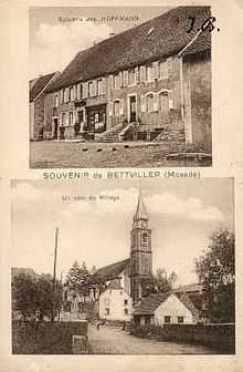
Bettviller, old postcard
See also
References
External links
| Wikimedia Commons has media related to Bettviller. |