Bettisfield
| Bettisfield | |
 Bettisfield |
|
| OS grid reference | SJ459351 |
|---|---|
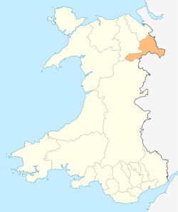
| Principal area | Wrexham |
| Ceremonial county | Clwyd |
| Country | Wales |
| Sovereign state | United Kingdom |
| Post town | WHITCHURCH |
| Postcode district | SY13 |
| Dialling code | 01948 |
| Police | North Wales |
| Fire | North Wales |
| Ambulance | Welsh |
| EU Parliament | Wales |
| UK Parliament | Clwyd South |
| Welsh Assembly | Clwyd South |
Coordinates: 52°54′49″N 2°48′20″W / 52.9136°N 2.8055°W
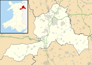
Bettisfield is a small village of about 150 dwellings in Wrexham County Borough on the Wales-England border. It lies south of the Llangollen Canal on the border with Shropshire, England within the historic English Maelor region which was formerly part of the county of Flintshire. The village lies close to Fenn's, Whixall and Bettisfield Mosses, an area of peat bog which was declared a national nature reserve in 1996 because of its importance for wildlife. The market towns of Whitchurch, Ellesmere and Wem each lie about 6 miles distant to the northeast, west and southeast respectively.
It is described in the Domesday book (1086) within the Cheshire Hundred of Duddeston recording 28 households and a value to Lord Edwin in 1066 of £18 9s, reducing to £3 in 1086.[1]
The village no longer has a shop, post office, pub, smithy or baker.[2]
References
- ↑ http://domesdaymap.co.uk/place/SJ4635/bettisfield/
- ↑ "Bettisfield Village Web". Retrieved 27 January 2014.
| ||||||||||||||||||||||||||||||||||||