Betsom's Hill
| Betsom's Hill | |
|---|---|
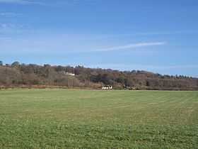
|
View of Betsom's Hill from the south-west | |
| Elevation | 251 m (823 ft) |
| Listing | County Top |
| Location | |
 Betsom's Hill Betsom's Hill in Kent | |
| Location | Westerham, England |
| OS grid | TQ 4355 5633 |
| Coordinates | 51°17′18″N 0°03′26″E / 51.2882°N 0.057188°ECoordinates: 51°17′18″N 0°03′26″E / 51.2882°N 0.057188°E |
Betsom's Hill is a hill on the North Downs, and the highest point in the county of Kent at 251 metres (823 ft). Situated between Westerham and Tatsfield, at the western edge of the county, it lies close to where the A233 crosses the Downs en route to Biggin Hill. This is the highest part of the North Downs, with Botley Hill the highest point, nearby to the west. The hill lies at the western end of the Kent Downs, an area of outstanding natural beauty.[1][2]
Geography
The crest of the hill was the location of a Victorian defence fort, one of twelve locations along the North Downs built to protect London in case of attack by foreign invaders crossing the channel. Known as Betsom’s Hill Fort or Westerham Fort, it was part of the London Defence scheme, and was intended to act both as a mobilisation centre for volunteer troops, and as an ammunition store. The fort which consisted of ramparts, casemates and a magazine has been partially demolished and converted for use as workshops, with private houses appropriately named Fort Cottages now occupying the site.[3][4][5][6]
The highest part of the hill is unmarked, in an area inaccessible to the public, making it the only county top that is on private land and which cannot be easily visited.[1] The lower slopes are more accessible, with the North Downs Way, a long distance trail passing beneath the crest, in an area known as Hill Park. Running in parallel at the foot of the scarp slope is another more ancient route, the Pilgrims Way.[6]
The artist and craftsman, John Paul Cooper selected Betsom’s Hill as the location for his house, workshop and studio. He designed the house in the Arts and Crafts style to reflect the local Kentish architecture, and lived there until his death in 1933.[7][8]
Westerham Heights

Westerham Heights the highest point of Greater London at 245 metres (804 ft) is also part of Betsom's hill, albeit with a separate name. It is located at TQ436564, adjacent to the A233 where the county boundary intersects the dip slope of the escarpment. On the north-west side of the hill, there is another boundary feature, a tripoint where the borders of Surrey, Kent and Greater London meet at Rag Hill.[1][6]
See also
References
- ↑ 1.0 1.1 1.2 Muir, Jonny (2011). The UK's County Tops: Reaching the top of 91 historic counties. Cicerone. p. 32. ISBN 9781849655538.
- ↑ Simon Edwardes (2001). "County Tops". The Mountains of England and Wales. Retrieved 20 April 2014.
- ↑ Matthews, Rupert (2010). Little Book of Surrey. The History Press. p. 117. ISBN 9780752462646.
- ↑ "London Mobilisation Centres - Gazeteer". Victorian Forts and Artillery. victorianforts.co.uk. Retrieved 17 April 2014.
- ↑ "London Mobilisation Centres". Victorian Forts and Artillery. victorianforts.co.uk. Retrieved 17 April 2014.
- ↑ 6.0 6.1 6.2 Ordnance Survey (2007). 187 Dorking & Reigate. OS Landranger Map Series. Ordnance Survey. ISBN 9780319229545.
- ↑ "J P Cooper and the Arts & Crafts Movement". gimson.leicester.gov.uk. 2012. Retrieved 18 April 2014.
- ↑ "John Paul Cooper - Biography". Birmingham Museums & Art Gallery Information Centre. bmagic.org.uk. 2012. Retrieved 17 April 2014.