Bethesda, Arkansas
| Bethesda, Arkansas | |
|---|---|
| Unincorporated community | |
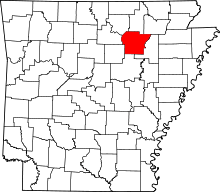
 Bethesda, Arkansas Bethesda's position in Arkansas. | |
| Coordinates: 35°47′29″N 91°47′19″W / 35.79139°N 91.78861°WCoordinates: 35°47′29″N 91°47′19″W / 35.79139°N 91.78861°W | |
| Country |
|
| State |
|
| County | Independence |
| Township | Washington |
| Elevation[1] | 196 m (643 ft) |
| Time zone | Central (CST) (UTC-6) |
| • Summer (DST) | CDT (UTC-5) |
| Area code(s) | 870 |
| GNIS feature ID | 57367 |
| U.S. Geological Survey Geographic Names Information System: Bethesda, Arkansas | |
Bethesda is an unincorporated community in Washington Township, Independence County, Arkansas, United States.[1] It is connected to the Arkansas Highway System via Highway 106S.[2]
References
- ↑ 1.0 1.1 "Bethesda, Arkansas". Geographic Names Information System. United States Geological Survey. Retrieved May 7, 2013.
- ↑ Arkansas Atlas and Gazetteer (Map) (Second ed.). DeLorme. § 34.
| |||||||||||||||||||||||||||||