Bethel, Polk County, Oregon

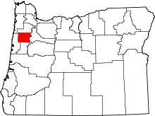
Bethel is an unincorporated community in Polk County, Oregon, United States at the base of the Eola Hills in Plum Valley. Bethel is considered a ghost town as the only remaining structure is a school,[1] now serving as a church. The locale was named by the Rev. Glen O. Burnett for a Church of Christ in Missouri where he had served as pastor.[1] Bethel is a common name for churches as it is a Hebrew word that means "house of god".[1] After traveling with his family on the Oregon Trail, Burnett settled on a Donation Land Claim in 1846.[2][3] Burnett later rode circuit to the surrounding area, preaching in nearby communities, including Rickreall.[3]
History
Another settler, Dr. Nathaniel Hudson, came to the area in 1851 and founded a school, Bethel Academy, in 1852.[1] Dr. Hudson moved to a new land claim in the Dallas area in 1854 and the academy closed.[1] In 1855 a new school named Bethel Institute was organized, and in 1856, the Oregon Territorial Legislature officially chartered the institute as one of the earliest colleges in the state, which was later renamed Bethel College.[1] Pioneer Jesse Applegate, who was a friend of Burnett's from Missouri and who traveled in the same wagon train, was on the college's board of trustees.[4] Bethel College had financial problems and in 1861 it merged with another Disciples of Christ institution: Monmouth College. Following a series of further mergers and name changes, Monmouth College became known as Western Oregon University.[1] The college building in Bethel was eventually dismantled.[3]
The first store in Bethel was built in 1855, and the post office followed in 1865.[2] At one time the town had a blacksmith shop, carpentry shop, and a wagon shop.[2] Bethel post office ran from 1865 to 1880.[1] The town was located on the wagon road that went between Amity and Monmouth, but when a new narrow gauge railway line was built in the area, through Amity, Dallas and Independence, it bypassed Bethel and instead was routed through McCoy, a decision which contributed to Bethel's decline.[2]
In October 2013, the school's former auditorium, renovated two months earlier to become the Eola Hills Charter School within the Amity School District, burned down.[5][6] The church building was not damaged.[6]
Agriculture and viticulture
Today, the area is part of the Eola-Amity Hills AVA with many wineries and vineyards, including Bethel Heights Vineyard which was named after the area.[7]
Gallery
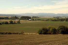
The Plum Valley area around Bethel.
References
- ↑ 1.0 1.1 1.2 1.3 1.4 1.5 1.6 1.7 McArthur, Lewis A.; Lewis L. McArthur (2003) [1928]. Oregon Geographic Names (Seventh Edition ed.). Portland, Oregon: Oregon Historical Society Press. p. 77. ISBN 0-87595-277-1.
- ↑ 2.0 2.1 2.2 2.3 "Polk County: 1846-1855". Pioneer History to about 1900: Churches of Christ & Christian Churches in the Pacific Northwest. Northwest College of the Bible. Retrieved 2008-03-14.
- ↑ 3.0 3.1 3.2 "Glen Owen Burnett". Pioneer History to about 1900: Churches of Christ & Christian Churches in the Pacific Northwest. Northwest College of the Bible. Retrieved 2008-03-14.
- ↑ "The Colleges Founded Before 1898". Pioneer History to about 1900: Churches of Christ & Christian Churches in the Pacific Northwest. Northwest College of the Bible. Retrieved 2008-03-14.
- ↑ Lynn, Capi (September 12, 2013). "Eola Hills Charter School gets facelift". Statesman Journal. Retrieved October 4, 2013.
- ↑ 6.0 6.1 Dewitt, Joce (October 3, 2013). "Fire consumes recently-renovated Eola Hills Charter School". Statesman Journal. Retrieved October 4, 2013.
- ↑ John Winthrop Haeger Pacific Pinot Noir pg 51-53 University of California Press, Berkeley, CA 2008 ISBN 978-0-520-25317-9
External links
- Historic images of Bethel from Salem Public Library
- Bethel Cemetery
Coordinates: 45°02′26″N 123°11′01″W / 45.04056°N 123.18361°W
| |||||||||||||||||||||||||||||||||


