Besançon – La Vèze Aerodrome
| Besançon - La Vèze Aerodrome Aérodrome de Besançon - La Vèze | |||||||||||
|---|---|---|---|---|---|---|---|---|---|---|---|
 | |||||||||||
| IATA: QBQ – ICAO: LFQM | |||||||||||
| Summary | |||||||||||
| Airport type | Public | ||||||||||
| Operator | CCI Doubs | ||||||||||
| Serves | Besançon | ||||||||||
| Location | La Vèze, Doubs, France | ||||||||||
| Elevation AMSL | 1,271 ft / 387 m | ||||||||||
| Coordinates | 47°12′19″N 006°04′50″E / 47.20528°N 6.08056°E | ||||||||||
| Runways | |||||||||||
| |||||||||||
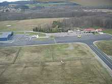
Besançon – La Vèze Aerodrome (French: Aérodrome de Besançon - La Vèze[2]) (IATA: QBQ[2][4], ICAO: LFQM) is an airport located 5.5 km (3.0 NM) southeast of Besançon in La Vèze, both communes of the Doubs department in the Franche-Comté region of France.[1]
Facilities
The airport resides at an elevation of 1,271 feet (387 m) above mean sea level. It has one runway designated 05/23 with an asphalt surface measuring 1,400 by 20 metres (4,593 ft × 66 ft).[1]
See also
-
 Media related to Aérodrome de Besançon-La Vèze at Wikimedia Commons
References
- ↑ 1.0 1.1 1.2 LFQM – Besançon La Vèze (PDF). AIP from French Service d'information aéronautique, effective 2 Apr 2015.
- ↑ 2.0 2.1 2.2 "Aérodrome de Besançon - La Vèze (QBQ / LFQM)" (in French). Union des Aéroports Français. Retrieved 12 May 2010.
- ↑ Airport information for LFQM from DAFIF (effective October 2006)
- ↑ "Besançon-La Vèze Airport (QBQ / LFQM)". Aviation Safety Network. Retrieved 12 May 2010.
External links
- (French) CCI Doubs