Bert, Allier
| Bert | ||
|---|---|---|
|
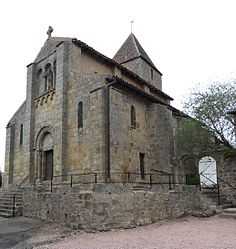
The church in Bert | ||
| ||
 Bert | ||
|
Location within Auvergne region  Bert | ||
| Coordinates: 46°19′32″N 3°42′28″E / 46.3256°N 3.7078°ECoordinates: 46°19′32″N 3°42′28″E / 46.3256°N 3.7078°E | ||
| Country | France | |
| Region | Auvergne | |
| Department | Allier | |
| Arrondissement | Vichy | |
| Canton | Jaligny-sur-Besbre | |
| Intercommunality | Pays de Lapalisse | |
| Government | ||
| • Mayor (2008–2014) | Jacques Caillault | |
| Area1 | 24.15 km2 (9.32 sq mi) | |
| Population (2008)2 | 272 | |
| • Density | 11/km2 (29/sq mi) | |
| INSEE/Postal code | 03024 / 03130 | |
| Elevation |
285–487 m (935–1,598 ft) (avg. 314 m or 1,030 ft) | |
|
1 French Land Register data, which excludes lakes, ponds, glaciers > 1 km² (0.386 sq mi or 247 acres) and river estuaries. 2 Population without double counting: residents of multiple communes (e.g., students and military personnel) only counted once. | ||
.svg.png)
Bert is a commune in the Allier department in central France.
Population
| Historical population | ||
|---|---|---|
| Year | Pop. | ±% |
| 1962 | 481 | — |
| 1968 | 514 | +6.9% |
| 1975 | 415 | −19.3% |
| 1982 | 410 | −1.2% |
| 1990 | 315 | −23.2% |
| 1999 | 273 | −13.3% |
| 2008 | 272 | −0.4% |
See also
References
| Wikimedia Commons has media related to Bert, Allier. |