Berry-Bouy
| Berry-Bouy | |
|---|---|
|
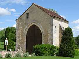
The Chapel of Saint-Aignan, in Berry-Bouy | |
 Berry-Bouy | |
|
Location within Centre region  Berry-Bouy | |
| Coordinates: 47°06′38″N 2°17′25″E / 47.1106°N 2.2903°ECoordinates: 47°06′38″N 2°17′25″E / 47.1106°N 2.2903°E | |
| Country | France |
| Region | Centre-Val de Loire |
| Department | Cher |
| Arrondissement | Vierzon |
| Canton | Mehun-sur-Yèvre |
| Intercommunality | Bourges Plus |
| Government | |
| • Mayor (2008–2014) | Bernadette Gouin |
| Area1 | 30.87 km2 (11.92 sq mi) |
| Population (2008)2 | 1,134 |
| • Density | 37/km2 (95/sq mi) |
| INSEE/Postal code | 18028 / 18500 |
| Elevation |
113–162 m (371–531 ft) (avg. 138 m or 453 ft) |
|
1 French Land Register data, which excludes lakes, ponds, glaciers > 1 km² (0.386 sq mi or 247 acres) and river estuaries. 2 Population without double counting: residents of multiple communes (e.g., students and military personnel) only counted once. | |
Berry-Bouy is a commune in the Cher department in the Centre region of France.
Geography
An area of forestry and farming comprising the village and several hamlets situated in the Yèvre river valley, some 5 miles (8.0 km) northwest of Bourges at the junction of the D160 with the N76 and the D60 roads.
Population
| Historical population | ||
|---|---|---|
| Year | Pop. | ±% |
| 1962 | 473 | — |
| 1968 | 501 | +5.9% |
| 1975 | 612 | +22.2% |
| 1982 | 807 | +31.9% |
| 1990 | 966 | +19.7% |
| 1999 | 934 | −3.3% |
| 2008 | 1,134 | +21.4% |
Places of interest
- The church of St.Hilaire, dating from the nineteenth century.
- The abandoned church of St.Pantaléon at Bouy.
See also
References
External links
| Wikimedia Commons has media related to Berry-Bouy. |
- Berry-Bouy on the Quid website (French)