Berry, Quebec
| Berry | |
|---|---|
| Municipality | |
|
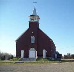
St-Gérard-de-Berry | |
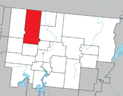 Location within Abitibi RCM. | |
 Berry Location in western Quebec. | |
| Coordinates: 48°49′N 78°16′W / 48.817°N 78.267°WCoordinates: 48°49′N 78°16′W / 48.817°N 78.267°W[1] | |
| Country |
|
| Province |
|
| Region | Abitibi-Témiscamingue |
| RCM | Abitibi |
| Settled | c. 1930 |
| Constituted | January 1, 1982 |
| Government[2] | |
| • Mayor | Jean-Pierre Naud |
| • Federal riding | Abitibi—Témiscamingue |
| • Prov. riding | Abitibi-Ouest |
| Area[2][3] | |
| • Total | 574.40 km2 (221.78 sq mi) |
| • Land | 577.14 km2 (222.83 sq mi) |
|
There is an apparent contradiction between two authoritative sources | |
| Population (2011)[3] | |
| • Total | 625 |
| • Density | 1.1/km2 (3/sq mi) |
| • Pop 2006-2011 |
|
| • Dwellings | 254 |
| Time zone | EST (UTC−5) |
| • Summer (DST) | EDT (UTC−4) |
| Postal code(s) | J0Y 2G0 |
| Area code(s) | 819 |
| Highways |
|
| Website |
www |
Berry is a municipality in the Canadian province of Quebec, located in the Abitibi Regional County Municipality. The municipality had a population of 625 as of the Canada 2011 Census.
The municipality includes the population centres of Saint-Gérard-de-Berry and Saint-Nazaire-de-Berry (48°43′10″N 78°15′33″W / 48.71944°N 78.25917°W).
Demographics
Population trend:[4]
- Population in 2011: 625 (2006 to 2011 population change: 11.6%)
- Population in 2006: 560
- Population in 2001: 489 (or 504 when adjusted to 2006 boundaries)
- Population in 1996: 501
- Population in 1991: 518
Private dwellings occupied by usual residents: 231 (total dwellings: 254)
Mother tongue:[5]
- English as first language: 1.8%
- French as first language: 96.4%
- English and French as first language: 0%
- Other as first language: 1.8%
Municipal council
- Mayor: Jean-Pierre Naud
- Managing Director: Sandra Boutin
- Councillors: Daniel Bouchard, Florina Poulin, Lucie Gosselin, Robert Bacon, Pascal Quévillon, Andrée Bacon
References
- ↑ Reference number 135551 of the Commission de toponymie du Québec (French)
- ↑ 2.0 2.1 "Berry". Répertoire des municipalités (in French). Ministère des Affaires municipales, des Régions et de l'Occupation du territoire. Retrieved 2011-01-11.
- ↑ 3.0 3.1 "Berry census profile". 2011 Census data. Statistics Canada. Retrieved 2011-01-11.
- ↑ Statistics Canada: 1996, 2001, 2006, 2011 census
- ↑ "Berry community profile". 2006 Census data. Statistics Canada. Retrieved 2011-01-11.
 |
Baie-James | | ||
| Lac-Chicobi | |
Lac-Chicobi Saint-Dominique-du-Rosaire | ||
| ||||
| | ||||
| Launay | Trécesson | Saint-Félix-de-Dalquier |
| ||||||||||||||||||||||||||