Bernardino de Campos
⊃
| Bernardino de Campos | |||
|---|---|---|---|
|
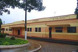
The town hall | |||
| |||
 Bernardino de Campos Location of Bernardino de Campos within Brazil | |||
| Coordinates: 23°00′47″S 49°28′27″W / 23.01306°S 49.47417°WCoordinates: 23°00′47″S 49°28′27″W / 23.01306°S 49.47417°W | |||
| Country | Brazil | ||
| State | São Paulo | ||
| Mesoregion | Assis | ||
| Microregion | Ourinhos | ||
| Area | |||
| • Total | 244.018 km2 (94.216 sq mi) | ||
| Elevation | 695 m (2,280 ft) | ||
| Population (2010[1]) | |||
| • Total | 10,777 | ||
| • Density | 44/km2 (110/sq mi) | ||
| Demonym | Bernardinense | ||
| Time zone | BRT (UTC-3) | ||
| • Summer (DST) | BRST (UTC-2) | ||

Bernardino de Campos is a municipality in the state of São Paulo in Brazil. The population in 2010 was 11,777 and the area is 244.018 square kilometres (94.216 sq mi).[1][2] The elevation is 695 metres (2,280 ft).
History
_060107_REFON.jpg)
Bernardino de Campos became a municipality on 9 October 1923 by State Law No. 1929, introduced on 22 December of the same year. Until 1886 it was a small village called Douradão, then it took the name of Figueira, and subsequently it was renamed as Peace district (Portuguese: distrito da Paz), and, finally, Bernardino de Campos, in honour of the President of the State of São Paulo of that time (Bernardino Dágola). With the arrival of the Sorocabana railroad in 1907, gradually it developed its economy, which is based on agriculture, especially coffee, cotton, sugarcane, maize, and soya beans plantations, and also agribusiness, and dairy and beef cattles.
Bernardino de Campos Anthem
The municipal anthem, with lyrics written by Peter Jamil Sawaya and music composed by Antenor Ferreira de Godoy, was approved by the city council on the bill discussed on 7 December 1970.[3]
Geography
Bernardino de Campos is located at 23 degrees south and 49 degrees 28 minutes west, at an altitude of 695 metres (2,280 ft), in the internal part of the State of São Paulo, 330 kilometres (210 mi) away from the capital, and it is surrounded by the Paranapanema and Pardo rivers. Its estimated population was 11,777 inhabitants in 2010 census.[1]
Demographics (2002 Census)
References
- ↑ 1.0 1.1 1.2 "Censo Populacional 2010" [Population Census 2010]. Censo Populacional 2010 (in Portuguese). IBGE. 29 November 2010.
- ↑ "Área territorial oficial" [Official Total Area] (in Portuguese). IBGE. 10 October 2002.
- ↑ Anthem of the Municipality of Bernardino de Campos (in Portuguese) at Wikisource.