Berkley–Dighton Bridge
| Berkley-Dighton Bridge | |
|---|---|
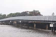 Temporary bridge | |
| Coordinates | 41°50′05.83″N 71°06′29.28″W / 41.8349528°N 71.1081333°WCoordinates: 41°50′05.83″N 71°06′29.28″W / 41.8349528°N 71.1081333°W |
| Carries | vehicular and pedestrian traffic |
| Crosses | Taunton River |
| Locale | Berkley and Dighton, Massachusetts |
| Preceded by | Weir St. Bridge |
| Followed by | Veterans Memorial Bridge |
| Characteristics | |
| Design | concrete arch bridge with closed spandrels |
| Total length | approximately 350 feet (110 m) |
| Width | 32 feet (9.8 m) |
| Longest span | 2 × 92 feet (28 m) |
| Number of spans | 4 |
| Clearance below | 12 feet (3.7 m) |
| History | |
| Construction begin | July 2012.[1] |
| Construction end | Spring 2015 (projected)[2] |
| Replaces | Berkley–Dighton Bridge (1896) |
 | |
The fourth Berkley–Dighton Bridge will be a four-span concrete arch bridge with closed spandrel walls of cast-in-place concrete, using pile-supported abutments and piers. The bridge will be made such that it will appear to be constructed of stone masonry rather than concrete. The two end spans will be 74 feet (23 m) and the two center spans will be 92 feet (28 m) for a total bridge length of approximately 350 feet (110 m).[3][4]
Bridges at this location are the only crossing over the Taunton River between the Veterans Memorial Bridge in Fall River and the Weir Street Bridge in Taunton.
Since August 2010, a temporary bridge has been in use while the new bridge is built. Construction on the bridge began in July 2012.[1] Completion of the new bridge is expected in Spring 2015.[2]
History
The first bridge at the site was built in 1801. There was no bridge on the site from 1853 to 1873.
The third bridge was dedicated in 1896 and demolished in 2010.
Proposals for the new bridge were discussed for many years, starting no later than 1975. The Massachusetts Highway Department (MHD) is now replacing the Berkley–Dighton Bridge because it was seriously structurally deficient, its swing span gears often jammed in the open position, forcing travelers miles to the north or south, and due to the inability for the bridge to handle emergency vehicles. The MHD estimates (2001 data) that 6,200 cars crossed the bridge each day. Bridge upgrade plans met with opposition for a variety of reasons, including concerns about the impact on local traffic. Commercial trucks were not allowed to use the old bridge. Also, the traffic lights are only triggered by cars stopping on a line in the road. This is very problematic for people not familiar with the bridge.
The replacement bridge will be a fixed structure, consisting of four pre-cast arch spans with closed spandrel walls of cast-in-place concrete, with approximately the same footprint as the existing bridge, using pile-supported abutments and piers. The finished bridge will be made such that it will appear to be constructed of stone masonry rather than concrete. The two end spans will be 74 feet (23 m) and the two center spans will be 92 feet (28 m) for a total bridge length of approximately 350 feet (110 m).[3][4]
It will be wider than the previous bridge by a total of approximately 12 feet (3.7 m), split between both sides of the old bridge, for a total of 32 feet (9.8 m) defined as two traffic lanes plus a 5.5-foot (1.7 m) sidewalk on the south (downstream) side of the bridge, similar to the previous bridge. A minimum of 12-foot (3.7 m) vertical clearance must be maintained from the mean high water line at the main span, requiring the roadway to be raised approximately 8.25 feet (2.51 m) higher than its current level. Other improvements include ADA-compliant sidewalks, wheelchair ramps, and driveway transitions, as well as better drainage, curbing, signage, guardrail, and pavement markings.[3] Completion of the new bridge is projected for Spring 2015.[2]
Temporary bridge
A temporary one-lane bridge with sidewalk has been provided during construction to the south of the permanent bridge site. The temporary bridge has improved weight capacity, allowing emergency vehicles to use it.[3] This bridge is open as of August 16, 2010.[5] The structure is a 3rd generation Bailey bridge.[5][6]
See also
References
- ↑ 1.0 1.1 Herald News, July 24, 2012
- ↑ 2.0 2.1 2.2 Mass DOT Project Page
- ↑ 3.0 3.1 3.2 3.3 Anderson, David R. (Acting Chief Engineer) (2007-09-18). Design Public Hearing at Dighton-Rehoboth Regional High School on Tuesday, September 18, 2007 for the proposed replacement of the Elm Street/Center Street Bridge (no. B-08-001=D-08-11) over Taunton River (Berkley-Dighton Bridge) in the Towns of Berkley and Dighton (PDF). MassHighway.
- ↑ 4.0 4.1 MassHighway district 5. "BERKLEY-DIGHTON- BRIDGE REPLACEMENT, B-08-001=D-08-011, ELM STREET (BERKLEY) CENTER STREET (DIGHTON) OVER THE TAUNTON RIVER". Retrieved 2008-12-05.
- ↑ 5.0 5.1 Temporary bridge project page
- ↑ 700XS Acrow Bridge
| |||||||||