Bennett Springs, Missouri
| Bennett Springs, Missouri | |
|---|---|
| Census-designated place | |
| Coordinates: 37°44′16″N 92°51′33″W / 37.73778°N 92.85917°WCoordinates: 37°44′16″N 92°51′33″W / 37.73778°N 92.85917°W | |
| Country | United States |
| State | Missouri |
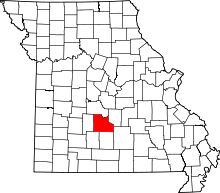
| Counties | Dallas, Laclede |
| Area | |
| • Total | 4.2 sq mi (10.9 km2) |
| • Land | 4.1 sq mi (10.7 km2) |
| • Water | 0.08 sq mi (0.2 km2) |
| Elevation | 878 ft (268 m) |
| Population (2010) | |
| • Total | 130 |
| • Density | 31/sq mi (12/km2) |
| Time zone | Central (CST) (UTC-6) |
| • Summer (DST) | CDT (UTC-5) |
| ZIP code | 65536 |
| Area code(s) | 417 |
| GNIS feature ID | 0735505[1] |
Bennett Springs is an unincorporated community and census-designated place in Dallas and Laclede counties, Missouri, United States. As of the 2010 census it had a population of 130.[2] It lies 12 miles (19 km) west of Lebanon on Missouri Route 64. The community is named after a spring that is reported variously as the third or fourth largest in the state, with an average daily flow of about one hundred million gallons, and which is the centerpiece of Bennett Spring State Park.
Bennett Spring State Park is one of the Missouri trout parks. The park features the largest spring of the four parks. Trout fishing, camping, and hiking are the main activities in the park, and the park also offers cabins, a swimming pool, nature center, and a full-service store.
References
- ↑ "US Board on Geographic Names". United States Geological Survey. 2007-10-25. Retrieved 2008-01-31.
- ↑ "Profile of General Population and Housing Characteristics: 2010 Demographic Profile Data (DP-1): Bennett Springs CDP, Missouri". U.S. Census Bureau, American Factfinder. Retrieved March 6, 2012.
External links
| |||||||||||||||||||||||||||||
| |||||||||||||||||||||||||||||||||
