Benifallet
| Benifallet | ||
|---|---|---|
| Municipality | ||
| ||
 Benifallet Location in Catalonia | ||
| Coordinates: 40°58′30″N 0°31′0″E / 40.97500°N 0.51667°ECoordinates: 40°58′30″N 0°31′0″E / 40.97500°N 0.51667°E | ||
| Country |
| |
| Community |
| |
| Province | Tarragona | |
| Comarca | Baix Ebre | |
| Area | ||
| • Total | 62.42 km2 (24.10 sq mi) | |
| Elevation | 19 m (62 ft) | |
| Population (2007) | ||
| • Total | 788 | |
| • Density | 13/km2 (33/sq mi) | |
| Time zone | CET (UTC+1) | |
| • Summer (DST) | CEST (UTC+2) | |
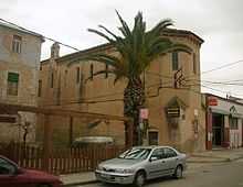
Benifallet centre
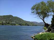
The Ebre River near Benifallet
Benifallet is a municipality in the comarca of Baix Ebre, in the province of Tarragona, in Catalonia, Spain.
This town is located by the Ebro River, below the Cardó Massif. It is popular among kayakers who make trips down the final Ebro Gorges.[1]
There are also locally arranged trips on rafts and kayaks down the Ebro Gorges.
References
External links
| Wikimedia Commons has media related to Benifallet. |
- Pàgina web de l'Ajuntament
- Informació de la Generalitat de Catalunya
- Informació de l'Institut d'Estadística de Catalunya
 |
Prat de Comte | El Pinell de Brai | Miravet | |
| Paüls | |
Rasquera | ||
| ||||
| | ||||
| Xerta | Tivenys |
| ||||||||