Bengaluru Pete
| Bengaluru Pete | |
|---|---|
| neighbourhood | |
 | |
 Bengaluru Pete Location in Bengaluru, India | |
| Coordinates: 12°57′46″N 77°34′33″E / 12.9627°N 77.5758°ECoordinates: 12°57′46″N 77°34′33″E / 12.9627°N 77.5758°E | |
| Country |
|
| State | Karnataka |
| District | Bangalore Urban |
| Metro | Bengaluru |
| Area | |
| • Total | 2.24 km2 (0.86 sq mi) |
| Elevation | 900 m (3,000 ft) |
| Languages | |
| • Official | Kannada |
| Time zone | IST (UTC+5:30) |
Bengaluru Pete (Kannada: ಬೆಂಗಳೂರು ಪೇಟೆ) is an area of Bangalore city.[1] It which was established by Kempegowda I (c. 1510–1570) in 1537 with roads laid in cardinal directions, and entrance gates at the end of each road[1] (Bengaluru Mahanagara Kannada: ಬೆಂಗಳೂರು ಮಹಾನಗರ) and has three taluks namely, Anekal, Bangalore North and Bangalore South. Kempegowda also called the Pete he built as his "gandu bhoomi" or "Land of Heroes". Pete (Kannada: Market centre) forms a well–defined body of markets which were associated with various trades and professions of the populace in the locality markets and given the names of trades pursued in such markets. The well known markets are the Tharagupete–market for grains, the Balepete – for Bangles and musical instruments, the Chikkapete and the Nagarthpete for textile trade, the Ballapurpete and the Ganigarapete market where oil is extracted by people of the Ganiga community, the Tigalarapete–flower market of gardeners, the Cubbonpete – textile manufacture by people of the Devanga community.[1]
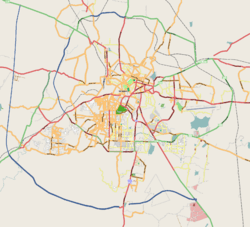
The Bengaluru Pete, established in 1537 around the Mud Fort built by Kempe Gowda I as the nucleus, with an area of 2.24 square kilometres (1 sq mi), has expanded to the present sprawling city of 741 square kilometres (286 sq mi) embracing multi ethnic population of 5.7 million; as per Census of India 2001,[2] the present population is reported as 6.6 million (2007)] and is thus known by the epithet "the Boom city". The other nicknames of the city also reflect the growth direction of the city, such as the Silicon Valley of India, the "Fashion Capital of India," and "The Pub City of India."[1][3][4][5]
The old Pete, structured in the contemporary style of deep networks of crowded streets, richly represented the multi cultural identity, social history, and economic geography of the times which are considered as hallmark in the planning and design of any urban agglomerate. The place has left its mark on literature with novels like Riddle of the Seventh Stone[6] being set in this part of Bangalore. These attributes have been further accentuated in the present day Bangalore city.[1] It is now the third largest metropolis in India.,[7] the largest city in the Karnataka state and 28th largest city in the world.[8]
History
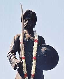
Even though historically Bengaluru is chronicled to the period of 900 AD, but with confirmed history of the Bengaluru Pete traced to 1537, when Kempe Gowda I (pictured), a Chieftain of the Vijayanagara Empire, widely held as the founder of modern Bangalore, built a mud fort and established the area around it as his province. He was the great grand son of Jaya Gowda who established the Yelahankanada Prabhu clan, in 1418 AD and whose principality was in Yelahanka, north of the present day Bangalore.[9] Kempegowda I who showed remarkable qualities of leadership from his childhood had a grand vision to build a new city which was further fuelled by his visits to Hampi (now a UNESCO heritage city) the then beautiful capital city of the Vijayanagar Empire. He persevered with his vision and got permission from the King Achutaraya, the ruler of the empire, to build a new city for himself. The King gifted 12 hoblis (revenue subdivisions) with an annual income of 30,000 varahas (gold coins) to his Chieftain Kempegowda to meet the expenses of his venture of building a new city.[10][11]
Kempegowda moved from his ancestral land of Yelahanka to establish his new principality, having obtained support from King Achutaraya. One version for the site selection process for the Bengalore Pete is that during a hunting expedition along with his Advisor Gidde Gowda, he went westward of Yelahanka and reached a village called Shivasamudra (near Hesaraghatta) some 10 miles (16 km) from Yelahanka where, in a tranquil atmosphere under a tree, he visualised building of a suitable city with a fort, a cantonment, tanks (water reservoirs), temples and people of all trades and professions to live in it for his future capital. It is also said that an omen of an uncommon event of a hare chasing away a hunter dog at the place favoured selection of the place and a dream of goddess Lakshmi (Hindu Goddess of wealth) that prophesized good indications of the events to happen further sealed his decision on the place for his capital. Following this event, on an auspicious day in 1537 A.D., he conducted a ground breaking ritual and festivities by ploughing the land with four pairs of decorated white bulls in four directions, at the focal point of the junction of Doddapet and Chikkapet, the junction (Pictured) of the present day Avenue Road and Old Taluk Kacheri Road (OTC).[10][11]
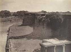
Thereafter, he constructed a mud fort (now in the western part of the city), with a moat surrounding it and which had nine large gates. Building of the mud fort is also steeped in a legend which is a tragic but heroic story. During the construction of the Fort it was said that the southern gate would fall off no sooner than it was built and human sacrifice was indicated to ward off the evil spirits. Kempe Gowda could not accept such a situation nor permit any such event to occur. But his daughter-in-law, Lakshamma, realising her father-in-Law's predicament, beheaded herself with a sword at the southern gate in the darkness of night. Thereafter, the fort was completed without any mishap. In her memory, Kempegowda built a temple in her name in Koramangala.[11] Thus, Kempegowda's dream fructified and the Bengaluru Pete evolved around the Mud fort called the Bangalore Fort. This mud fort (see infobox) was converted and enlarged into the present stone fort during Chikkadeva Raya Wodeyar's rule between 1673 AD – 1704 AD and Hyder Ali's rule, in 1761.
It has also been reported that Guru Nanak, the Sikh Guru, on his way back from Sri Lanka halted at Bangalore. Kempegowda met him and sought his blessings.Gurunak not only blessed Kempegowda but als told him to develop the place.[12]
- The Pete
The Pete as built by Kempegowda I had two main streets, namely the Chikkapete Street, which ran east–west, and the Doddapete Street, which ran north–south. Their intersection formed the Doddapete Square (present Avenue road), the heart of Bangalore.[13] Halasoor, also called Ulsoor (east), Sondekoppa (west), Yelahanka (north), and Anekal (south) were the four gates erected at the cardinal directions. Five more gates were also built and these were named as Varthur, Sarjapur, Kanakanahalli, Kengeri and Yeshwantapura gates. Relating the Pete to the present landmarks of the city, the following are mentioned:
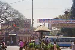
- The fort extends from 'Binny Mill' in the west to the Ulsoor Police Station in the east, and from the Anjaneya Temple (pictured) near Mysore Bank in the north to Prof. Shivashankar Circle (near Fort High School) in the south.
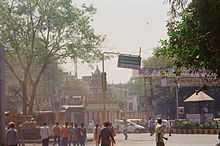
- The main street extends from Sunakkalpet Circle in the east to the Goodshed Road in the west and this stretch is now known as Old Taluk Kacheri Road.
- The main street of the Pete from Avenue Road (Doddapete Road) in the north to Krishna Rajendra (KR) Road in the south.[10]
Temples and lakes were planned and residential layouts, or agraharas (residential area of Brahmins), around each temple were built during the rule of Kempegowda I, in and around the Pete, which along with the mud fort built by him, changed Bengaluru from a village to a centre of culture based on the Hindu religion. These developments were fashioned in the tradition of the Vijayanagara cities. The montage of bazaars, temple complexes and agraharams in and around the Pete got a further fillip during the rule of Kempegowda II, who built four cardinal towers setting limits for the growth of the Bengaluru pete.[14] But the growth of Bengaluru has far outstripped these limits by several folds.
The visionary approach of the Kempe Gowdas, perceiving the needs of the growing population of the Pete, resulted in building a number of lakes/ponds (called 'Kere' in the Kannada language)and temples (some are pictured in the gallery) in and around the fort. Some of the notable ones are :[10]
- The lakes in the inner circle are the Kempe Gowda Agrahara, Siddikatte, Sampangi, Dharmambudhi, Kempambudhi kere, and Karanji.
- The outer circle lakes were the Yediyur, Chennamma, Mavalli, Akki Thimmana halli, Jakkaraya kere. Most of the lakes have been encroached for the present urban needs
- The early temples built or improved were the Gavi Gangadhareshwara Temple, Nandi (Bull Temple) (Basavanna), Dodda Ganapathi, Karanji Anjaneya, Ulsoor Someswara, Koramangala Lakshmi, Mahakali, Veerabhadra, Vinayaka and Kalabhairava.
- Pete expansion
With the decline of the rule of Kempegowdas' clan, the Maratha rule and culture followed for some time. In 1638, Pete was conquered by Bijapur Sultan who ruled for the next 50 years. The Mughals took over in 1687 and leased the town and the surrounding areas to Chikkadeva Raya Wodeyar of the Mysore Kingdom, in 1690 AD. Chikkadeva Raya Wodeyar (1673 AD −1704 AD) built an oval shaped fort south of the old mud fort and after his death in 1704 AD, the rule of Hyder Ali and Tippu Sultan ensued till Tippu's death at the hands of the British in 1790 AD. It was Hyder Ali who rebuilt the mud Fort in stones. During their reign, a palace called the Tippu's Palace was built at the South end of the fort and a Hindu temple for Lord Srinivasa was also built adjoining the Tippu Palace, which is called the "Kote Venkataramana Temple" or "Fort temple". At this stage, the old Pete had expanded to a circumference of 5 kilometres (3 mi) into a prosperous economy with well laid out streets and flourishing shops [the market stretched from the north gate – the present Avenue road (pictured)] – of the Pete to the oval fort]. A beautiful botanical garden called the Lalbagh was also built in 1760 AD. The Pete became not only a commercial centre but also a military centre of strategic importance.[4][14] The Pete initially developed as a pedestrian precinct with the public spaces evolving with bazaar streets, temple squares, lakes and maidans (open grounds). But, under Wodeyars' rule, during the British Raj, in the 19th century, public gardens developed along with the suburbs, adjoining the traditional Pete, in western planning concepts with wider roads. The streets were built in gridiron pattern and designed to cater to heavy vehicular traffic.[1][14]
During the colonial rule the British expanded the Pete to include the cantonment to position their garrison, which was separated by an 11.5 kilometres (7 mi) wide strip of open land. The colonial city by coincidence decongested the old native city (Pete) and also provided much needed 'lung space'.[14] Since then several developments, post independence (1947 till date), have led to the rapid growth of the city.
Present urban status of pete
The Pete as it exists today (overlay map) in the heart of Bangalore Metropolis reported a population of 112,076 persons in a diverse use area (Residential: 37.5%; Commercial: 34.6%; Industrial: 6.1%). The trades which defined the Pete in the past have remained but have enormously prospered with modern trades, as distinct entities with a built-in relationship between occupation and community with deep-rooted traditional patterns of living. An urban infrastructure study reported in a scholarly article by Champaka Rajagopal in the Journal of the Development and Research Organization for Nature Arts has the following remarkable observations.[1]
- The Pete is presently, inhabited mainly by people from the Devanga, Tigala, Javheri Rajput, Marwari, Gujarati, Jain and Muslim communities.
- In the Pete, industrial and trade activities overflow into the streets, and incredibly encroach public space.
- Within the Pete precincts, the Gujarati, Marwari and Jain communities from north western parts of the country, generally bankers, have gradually diversified their trade from pearl market to textile, garments, jewellery, paper, chemists, druggists, cutlery, metal, hardware and electrical goods.
- Medarpete is house to the more than 500 families of rajput community having their gurudwara durbar saheb sangh they are into household plastic goods, medarpete is the wholesale market for plastic goods.
- Marwaris of the Pete, for whom family still controls inheritance and management of their own business, have diversified into several trades – including assembly of computers – that new economies offer
- Muslim communities of Kumbarpete, like the takaras (traders in household stone equipment), chapparband (menders of roof tiles), sikkalgar (dealers in copper/ brass vessels) and phuleras (traders of flowers) have, over time, diversified into the construction industry
- In the Tharagupete area hardware dealers (mostly dominated by Muslims) say that they have benefited greatly by the rise in global markets, particularly in the construction industry.
- In spite of diversification of trade and industry most of the areas within the Pete have retained their strong presence of community based occupation such as:
- Avenue Road (old Doddapete road) retains its traditional trade in garments and textiles, jewellery and pawn brokering
- Krishna Rajendra (KR) Market is known for trade in vegetables, fruits, flowers, iron and steel utensils
- Sultanpete trades in paper and in Cubbonpete trade is in textile industry
- All the above informal industries of the Pete are reported to have generated more jobs for people. The garment industry, in particular, registered volume of exports more than the Information Technology.
- According to the Comprehensive Development Plan (CDP) of Bangalore, 1995 that determines zoning, land use and transport within Bangalore Metropolitan Area (which has zoned 1,306 square kilometres (504 sq mi) area of the Bangalore Development Authority), has zoned the city into intensely developed (Zone A), moderately developed (Zone B) and sparsely developed (Zone C) areas. The Pete falls within the intensely developed zone.
- The existing trends of development in the Pete is of high built up area and people density that has resulted in less liveable conditions
- A detail study of the changing socio–economic patterns that could bring about in reality different development patterns, is essential by introducing new building byelaws by the municipal corporation
- . Therefore, the Pete skirts through formal enforceable legal systems but continue to develop in an alternative, less liveable way due to strong local politics.
The paper has chronicled the urban planning involving highly intertwined issues of the "pete" succinctly and the conclusion drawn from this study of the Pete is better reflected, as quoted:
For a place as intricate and complex as the Pete, formulation of regulations through public participation would be sensitive and challenging. Communities, religions and economies have coexisted here but not without tensions… an inclusive methodology would help direct the role of the urban designer as a 'less cavalier' coordinator, addressing diverse disciplines and negotiating the efforts of various groups that shape urban places, especially for informal urban settings such as the Pete.[15]
Gallery
-
Anjaneya temple built by Kempegodas at the Avenue (Doddapete) road crossing
-
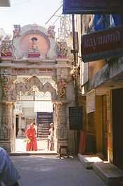
Arch entrance of a Jain temple in Chickpete
-
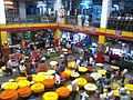
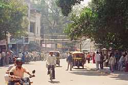
View of K R Market on a weekday.
-
_above_the_caves_of_the_main_shrines_of_Gavigangadreswara_temple_in_Bangalore.jpg)
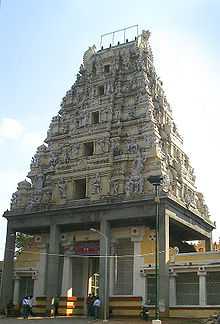
Entrance of the ancient Sri Gavi Gangadareshwara Temple (cave temple) renovated by Kempegowdas
-

Kote srinivasa temple near the Fort
-
Tippu Sultan's palace in Bangalore built in 1761, next to the Srinivasa temple, near the old Fort
-

Someshwara temple built by Kempegowdas
-
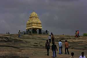
One of the four Cardinal towers of Bangalore erected in the Lalbagh
-
The Nandi Temple or Bull Temple is a famous temple located in the suburbs of the pete built during Kempegowdas rule
-
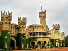
Bangalore Palace built by the Wodeyars of the rulers of Mysore in the 19th century
-
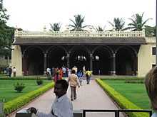
Bangalore City market near the old Fort
-

K.R. Market, Bangalore.
See also
- K. R. Market
- Kempegowda I
- Bangalore Fort
- Lalbagh
References
| Wikimedia Commons has media related to Bengaluru Pete. |
- ↑ 1.0 1.1 1.2 1.3 1.4 1.5 1.6 Rajagopal, Champaka (Spring–Summer 2008). "Bangalore: The informal economy of the Historic Pete" (PDF). Journal of the Development and Research Organization for Nature Arts and Heritage (Indian Heritage Cities Network) V (1): 137–46. Retrieved 7 February 2009.
- ↑ "Census population" (PDF). Census of India. www.cicred.org. pp. 6&21. Retrieved 7 March 2009.
- ↑ "Bangalore". Retrieved 6 March 2009.
- ↑ 4.0 4.1 "About Bangalore". Department of Bangalore IT and Biotechnology, Government of Karnataka. Archived from the original on 19 September 2006. Retrieved 5 March 2009.
- ↑ "Study area, Bangalore". Retrieved 5 March 2009.
- ↑ Madhukar, Jayanthi (18 October 2010). "Into B'lore's underbelly". Bangalore Mirror. Retrieved 29 May 2012.
- ↑ "India: largest cities and towns and statistics of their population". World Gazetteer. Retrieved 7 March 2009.
- ↑ "World: largest cities and towns and statistics of their population". World Gazetteer. Retrieved 7 March 2009.
- ↑ "Banaglore". Retrieved 5 March 2009.
- ↑ 10.0 10.1 10.2 10.3 "A grand dream". Chennai, India: Hindu. 18 July 2002. Retrieved 6 March 2009.
- ↑ 11.0 11.1 11.2 "Kempe Gowdas of Bengalooru (Bangalore by Dr. R. Narayana". Volkkaliga Parishat of America (VPA) –web pagemyvpa.org. Retrieved 6 March 2009.
- ↑ "Multiple City:Writings On Bangalore edited by Aditi De,Part III, Article 9, The Cities Within – New Shoes and Old Roots: The Cultural Backdrop of Bangalore by Chiranjeevi Singh,pages 49–59". Penguin Books India,New Delhi. 2008. Retrieved 12 March 2009.
- ↑ R.L.Rice (2001). Mysore, A Gazetteer Compiled for Government. Asian Educational Services. p. 1454. ISBN 81-206-0977-8. Retrieved 7 March 2009.
- ↑ 14.0 14.1 14.2 14.3 "Public Space in Bangalore: Present And Future Projections" (PDF). pp. 33–68. Retrieved 7 March 2009.
- ↑ Rajagopal, Champaka (Spring–Summer 2008). "Bangalore: The informal economy of the Historic Pete" (PDF). Journal of the Development and Research Organization for Nature Arts and Heritage (Indian Heritage Cities Network) V (1): 145–46. Retrieved 7 February 2009.
| ||||||||||||||||||||||||||||||||||||||