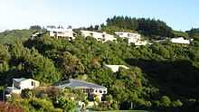
Belmont, Wellington
- For the suburb of North Shore (Auckland), see Belmont, Auckland.
| Belmont | |
|---|---|
| Basic information | |
| Local authority | Lower Hutt City |
| Population | 2,568 (2006 [1]) |
| Facilities | |
| Surrounds | |
| Northeast | Kelson |
| East | Avalon |
| Southeast | Naenae |
| South | Boulcott |
| Southwest | Tirohanga |
Belmont is a suburb of Lower Hutt, to the north of Wellington in the North Island of New Zealand. It is on the west bank of the Hutt River, on State Highway 2 (SH2), the Wellington-Hutt main road, and across the river from the centre of Lower Hutt.
It borders the Belmont Regional Park (open 8am - dusk) and as such is surrounded by native bush and beautiful views.
Local activities
The area offers access to different day walks, including Boulder Hill (Peneplain Boulders, via Hill Road), and Belmont Trig (via Stratton Street) which offers panoramic views of Wellington. This is a popular area for mountain biking, with Old Coach Road and Hill Road Track Carpark as favourite tracks. The Belmont Pony Club provides a fantastic set-up for young horse riders with quiet and safe exercise areas on hand.
Raphael House
The area is home to Raphael House Rudolf Steiner School (a Waldorf school).

History: Belmont Picnic Grounds
The Belmont Picnic Grounds were a popular venue for outings in the early 1900s. They were operated originally by Mr Kilminster (ca. 1911-1914),[2] then by Mr C. E. Clarke (ca. 1914-1919)[3] and finally by Mrs Eliza Presants, wife of Philip Robert Presants, ca. 1920-1932.[4][5]
GNS
The Institute of Geological and Nuclear Sciences has a kiosk substation in the area.
External links
References
- Belmont Railway Station, New Zealand (closed 1954)
Coordinates: 41°11′27″S 174°55′11″E / 41.19083°S 174.91972°E