Belfort Gap

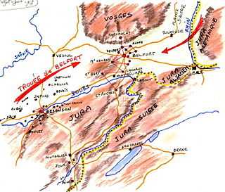
The Belfort Gap (French: Trouée de Belfort) or Burgundian Gate (German: Burgundische Pforte) is a plateau located between the northern rim of the Jura Mountains and the southernmost part of the Vosges in France. It marks the divide between the drainage basins of the Rhine River in the east and that of the Rhône (Doubs and Saône) in the west, part of the European Watershed between the North Sea and the Mediterranean Sea.
Geography
Its elevation varies between 345 m (1,132 ft) at its lowest and a little more than 400 m (1,300 ft). The roughly 40 km (25 mi) wide terrain corridor connects the French département of Haut-Rhin, south of the région Alsace and the Territoire de Belfort, north of the région Franche-Comté.[1] The passage allows warm Mediterranean flows to advect northeastwards into the Upper Rhine Plain and the Middle Rhine Valley.
Lines of communication that traverse the Belfort Gap include the French Route nationale 83 and the A36 autoroute, the railway line from Paris to Basel and the planned LGV Rhin-Rhône high-speed railway, as well as the Rhône-Rhine Canal.
History
Two important routes crossed the area already during the Roman era, which allowed Julius Caesar to quickly move troops which were used to defeat Ariovistus and force his German tribes (primarily Suebi) in the province of Germania Superior to retreat across the Rhine. After the Migration Period and the Decline of the Roman Empire in the 5th century, Germanic Alemanni tribes settled east of the plateau, while the Burgundians established a first kingdom west of it. Both had been incorporated into the Kingdom of Francia by the early 6th century, while the highland remained the linguistic border between Germanic and Romance languages.
Upon the division of the Carolingian Empire in the 9th century, the area again marked the border between East Francia, i.e. the German stem duchy of Swabia, in the east and the Kingdom of Arles (Upper Burgundy) in the west. While the Swabian Alsace region was a constituent part of the Holy Roman Empire in 962, the adjacent County of Burgundy in the west was not incorporated until 1033. About 1042 the County of Montbéliard (Mömpelgard) was established on Burgundian territory right at the border with the Alsacien Sundgau region. Montbéliard fell to the Swabian House of Württemberg in 1407, while the Sundgau region around Ferrette (Pfirt) and the French-speaking town of Belfort (Beffert) had been acquired by the Habsburg duke Albert II of Austria by marriage in 1324.
The area again marked a borderline, when the Habsburgs had to cede the Sundgau to the Kingdom of France according to the 1648 Peace of Westphalia. Over the following centuries of French–German enmity, the strategically important town of Belfort, situated at the western entrance into the corridor, has played the role of a bolt against invasions over the centuries whether originating from the west or the east and remained a communications center that is impossible to circumvent. After the Franco-Prussian War and the Siege of Belfort, the language border was used in 1871 to determine the new demarcation line between the newly established German Empire and the French Third Republic retaining Belfort. A series of fortifications was set up to ensure defense of the area. The most recent military advance through the Belfort Gap was that of the French I Corps in November 1944.[2]
Notes
- ↑ The second main road out of Alsace is the Col de Saverne (Saverne Pass), linking the département of Bas-Rhin (Alsace) to the département Moselle, région Lorraine. Alsace is also accessible via the Tunnel Maurice-Lemaire and some other vosgian passes but they are neither allowed to heavy truck traffic (and dangerous goods in the tunnel) nor equipped with railroads.
- ↑ Riviera to the Rhine (U.S. Army in World War II Series), pp. 412-432. Jeffrey J. Clarke and Robert Ross Smith. Washington: Government Printing Office, 1993.
- This article incorporates text translated from the corresponding French Wikipedia article as of November 22, 2008.