Belaya River (Kama)
| Belaya River, Ağidel, Aghidhel River | |
|---|---|
 Belaya River in Ufa | |
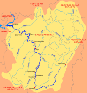 Belaya River basin | |
| Origin |
Iremel mountain 54°33′0″N 59°3′0″E / 54.55000°N 59.05000°E |
| Mouth |
Kama, Nizhnekamsk Reservoir 55°53′14″N 53°36′14″E / 55.88722°N 53.60389°ECoordinates: 55°53′14″N 53°36′14″E / 55.88722°N 53.60389°E |
| Basin countries | Bashkortostan, Russia |
| Length | 1,430 km (890 mi) |
| Avg. discharge | 858 m3/s (30,300 cu ft/s) (near Birsk) |
| Basin area | 142,000 square kilometres (55,000 sq mi) |
Belaya River (Russian: Бе́лая; Bashkir: Ағиҙел [ä.ʁi̠.ˈðɪ̞l], ![]() pronunciation ; Tatar Cyrillic: Агыйдел, Latin: Ağidel [ˌʌɣiˈdel]) is a river in Bashkortostan, Russian Federation. Its source lies in the south-western Ural Mountains.
pronunciation ; Tatar Cyrillic: Агыйдел, Latin: Ağidel [ˌʌɣiˈdel]) is a river in Bashkortostan, Russian Federation. Its source lies in the south-western Ural Mountains.
It is 1,210 kilometres (750 mi) long.[1]
Settlements along the Belaya include Beloretsk, Sterlitamak, Ufa (at the confluence with the Ufa River), and Birsk. The Belaya flows into the Kama River near Neftekamsk.
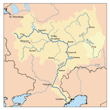
Map of the Volga watershed with the Belaya highlighted
References
- ↑ "Definition of Belaya River in English". Oxford Dictionaries. Oxford University Press. Retrieved 21 December 2013.
| Wikimedia Commons has media related to Belaya River. |
| |||||||||||||||||||||
