Beit Zayit
| Beit Zayit | |
|---|---|
 | |
 Beit Zayit | |
| Coordinates: 31°46′57.67″N 35°9′33.62″E / 31.7826861°N 35.1593389°ECoordinates: 31°46′57.67″N 35°9′33.62″E / 31.7826861°N 35.1593389°E | |
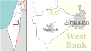
| Council | Mateh Yehuda |
| Region | Jerusalem corridor |
| Affiliation | Moshavim Movement |
| Founded | 1949 |
| Founded by | Jewish immigrants from Yugoslavia, Hungary, Romania, Yemen, and Egypt |
| Website | www.beit-zait.org |
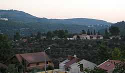
Beit Zayit (Hebrew: בֵּית זַיִת, lit. House of Olives) is a moshav in Israel located seven kilometres west of Jerusalem. Beit Zayit is under the jurisdiction of Mateh Yehuda Regional Council. In 2007, it had a population of 1,300.
The village was established in 1949 by Jewish immigrants from Yugoslavia, Romania and Hungary. Later, olim from Yemen and Egypt also settled in the village. The economy was based on fruit orchards, vegetables, poultry and other farm products.[1]
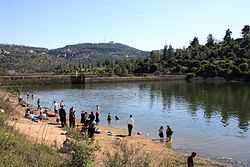
Beit Zayit lies on the edge of the Jerusalem Forest and operates a public swimming pool. Nearby is the Ein Kerem dam, built to store winter flood waters.[1]
A village named Beit Zayit is mentioned in the book of the Maccabees, but it is believed to have been further north, possibly at the site of the Palestinian Christian town of Bir Zeit, north of Ramallah.[1]
Dinosaur footprints, probably of Struthiomimus,[2] were discovered in Beit Zayit are on display at the Hebrew University of Jerusalem.[3]
With the expansion of the moshav in the late 1990s, including the purchase of land by newcomers and renovation of old homes, Beit Zayit has become a trendy alternative to living in Jerusalem.[4]
References
- ↑ 1.0 1.1 1.2 Beit Zayit, Jewish Virtual Library
- ↑ Khalaf-von Jaffa, Norman Ali Bassam Ali Taher (2006). Ornithomimid Dinosaur Tracks from Beit Zeit, West of Jerusalem, Palestine. Gazelle: The Palestinian Biological Bulletin. Number 56, August 2006. pp. 1–7.
- ↑ Kids love Israel, Israel loves kids: a travel guide for families, Barbara Sofer
- ↑ Posh Israeli suburb grows out of a farming co-op
External links
- Village website (Hebrew)