Beit Nekofa
| Beit Nekofa בֵּית נְקוֹפָה | |
|---|---|
 | |
 Beit Nekofa | |
| Coordinates: 31°48′9.95″N 35°7′31.07″E / 31.8027639°N 35.1252972°ECoordinates: 31°48′9.95″N 35°7′31.07″E / 31.8027639°N 35.1252972°E | |
| District | Jerusalem |
| Council | Mateh Yehuda Regional Council |
| Founded | August 1949 |
| Founded by | Immigrants from Yugoslavia |
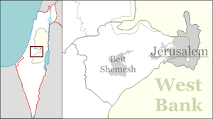
Beit Nekofa (Hebrew: בֵּית נְקוֹפָה) is a moshav in the Jerusalem District of Israel, subordinate to the Mateh Yehuda Regional Council. Beit Nekofa is located in the Jerusalem Corridor, about 10 km west of central Jerusalem, next to Highway 1 and the Hemed Interchange, between Mevaseret Zion and Kiryat Ye'arim, south of Kiryat Anavim.[1]
Etymology
Beit Nekofa's name may be based on the name of an ancient town, Nukveta (Hebrew: נוּקְבְתָא) of Benjamin, mentioned in the Talmud, from which the ancestors of Rabbi Judah haNasi are said to have come from. Nukveta is from the Hebrew word נִקְבָּה, Nikba, or tunnel.[2]
According to Zev Vilnay, Beit Nekofa was mentioned in the Jerusalem Talmud as the place of residence of a family of Kohanim. The Hebrew root of the name is Nakaf (נ-ק-פ, taken from Joshua 17:6), referring to the collection of olives by means of hitting the tree, as opposed to harvest by hand (the Hebrew root Masak).[3]
In Arabic, Naqb means (mountain) passage. An Arab village, Bayt Naqquba, existed in the same location until the 1948 Arab–Israeli War when the area came under Israeli control and the villagers were expelled. After the end of the war, the residents were allowed to return and established a new village, Ein Neqquba, on the opposite side of Highway 1.[2][3][4]
History
Beit Nekofa was founded in August 1949 by seven families who immigrated to Israel from Yugoslavia. The Neveh Ilan-Beit Nekofa area was devastated by fire in the summer of 1996.[5]Two thousand dunams of forest and dozens of buildings in Kibbutz Kiryat Anavim and Moshav Beit Nekofa were destroyed or damaged in the blaze.[6]
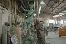
Beit Nekofa runs a bronze foundry that employs many Arabs from the surrounding villages.[7]
References
- ↑ Gold Atlas (Map) (2009 ed.). 1:100,000 (in Hebrew). Mapa. p. 32. § Het18. ISBN 965-521-082-0.
- ↑ 2.0 2.1 HaReuveni, Immanuel (1999). Lexicon of the Land of Israel (in Hebrew). Miskal - Yedioth Ahronoth Books and Chemed Books. p. 126. ISBN 965-448-413-7.
- ↑ 3.0 3.1 Vilnai, Ze'ev (1976). "Beit Nekofa". Ariel Encyclopedia (in Hebrew). Volume 1. Tel Aviv, Israel: Am Oved. p. 778.
- ↑ Morris (1994), "Chapter 8: The Case of Abu Ghosh and Beit Naqquba, al-Fureidis and Jisr Zarka in 1948 - or Why Four Villages Remained", pp. 257–289
- ↑ MKs salute the trees
- ↑ Report exonerates Fire Dep't
- ↑ Give and Take, Jerusalem Post
Bibliography
- Benny Morris (1994): "1948 and after; Israel and the Palestinians." ISBN 0-19-827929-9.