Beira, Mozambique
| Beira | |
|---|---|
|
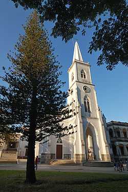
Beira Cathedral | |
 Beira | |
| Coordinates: 19°50′S 34°51′E / 19.833°S 34.850°E | |
| Country |
|
| Provinces | Sofala Province |
| Founded | 1887 |
| City Status | 1907 |
| Government | |
| • Mayor | Daviz Simango |
| Area | |
| • Total | 633 km2 (244 sq mi) |
| Elevation | 14 m (46 ft) |
| Population (2007 census) | |
| • Total | 436,240 |
| • Density | 690/km2 (1,800/sq mi) |
Beira is the second largest city in Mozambique. It lies in the central region of the country in Sofala Province, where the Pungue River meets the Indian Ocean. Beira had a population of 412,588 in 1997, which grew to an estimated 546,000 in 2006. It holds the regionally significant Port of Beira which acts as a gateway for both the central interior portion of the country as well as the land-locked nations of Zimbabwe, Zambia and Malawi. Beira was originally developed by the Portuguese Mozambique Company in the 19th century, and directly developed by the Portuguese colonial government from 1947 until Mozambique gained its independence from Portugal in 1975.
History
Portuguese rule

The city was established in 1890 by the Portuguese and soon supplanted Sofala as the main port in the Portuguese-administered territory. Originally called Chiveve, after a local river, it was renamed to honor the Portuguese Crown prince Dom Luís Filipe who, in 1907, was the first member of the Portuguese royal family to visit Mozambique. Traditionally the Portuguese Crown prince carried the title of Prince of Beira, a historical province of mainland Portugal. The Portuguese built the port and a railway to Rhodesia, Portuguese families settled in the newly founded locality and started to develop commercial activities. With the growth of the village, in 1907 the Portuguese Crown elevated Beira to the status of city (cidade). Headquarters of the Companhia de Moçambique (Mozambique Company) from 1891,[1] the city's administration passed from the trading company to the Portuguese government in 1942. In 1966, the construction of a new railway station was completed. Before Mozambique's independence from Portugal, as a city of Portuguese Mozambique, Beira was noted for its well-equipped seaport, one of the major facilities of its kind in all East Africa, tourism, fishing and trade. The city prospered as a cosmopolitan port with different ethnic communities (Portuguese, Indian, Chinese, Bantus such as the Sena and Ndau) employed in administration, commerce, and industry. A large English-speaking population was the result of being a favourite holiday destination for white Rhodesians. One reminder of this is the Grande Hotel, built by the Portuguese, near the shore of the Indian Ocean.[2][3] By 1970, the city of Beira had 113,770 inhabitants.
After independence from Portugal
After independence from Portugal in 1975, many white ethnic Portuguese left the city. Mozambique was ravaged by a civil war from 1977 to 1992, opposing Marxist FRELIMO, which controlled the government, to the rebels of RENAMO, descending to near total chaos in a couple of years. The famine, disease and poverty-stricken country collapsed. In Beira, the famous Grande Hotel was occupied by around 1,000 homeless Beirans, and by the end of the civil war it was in near-ruins.
The 2000 Mozambique flood devastated Beira and the surrounding region, leaving millions homeless and severely damaging the local economy.
Climate
Beira features a tropical savanna climate (Köppen Aw). Average temperature in January is 28.5 °C (83 °F) and in July (the coldest month) it's 21 °C (70 °F). The rainy season runs roughly from November to April.
| Climate data for Beira | |||||||||||||
|---|---|---|---|---|---|---|---|---|---|---|---|---|---|
| Month | Jan | Feb | Mar | Apr | May | Jun | Jul | Aug | Sep | Oct | Nov | Dec | Year |
| Average high °C (°F) | 31 (87) |
30 (86) |
29 (85) |
28 (83) |
26 (79) |
24 (76) |
24 (75) |
25 (77) |
27 (80) |
28 (82) |
29 (84) |
29 (85) |
27.5 (81.6) |
| Average low °C (°F) | 26 (79) |
26 (79) |
26 (78) |
24 (75) |
21 (70) |
19 (66) |
18 (64) |
19 (66) |
21 (70) |
23 (73) |
24 (76) |
26 (78) |
22.8 (72.8) |
| Average precipitation mm (inches) | 267 (10.5) |
259 (10.2) |
264 (10.4) |
117 (4.6) |
66 (2.6) |
41 (1.6) |
33 (1.3) |
33 (1.3) |
30 (1) |
33 (1.3) |
122 (4.8) |
244 (9.6) |
1,509 (59.2) |
| Source: Weatherbase [4] | |||||||||||||
Demographics
| Year | Population[5] |
|---|---|
| 1970 | 113 770 |
| 1980 | 230 744 |
| 1997 | 412 588 |
| 2007 | 436 240 |
| 2008 | 439 264 |
Tourism
Tourism is a potential industry for Beira, but returns are limited. Potential tourist attractions include the cathedral, lighthouse, Macuti Beach and the Grande Hotel Beira. North of the city is the former Gorongosa national park. There are few restaurants or hotels of a tourist standard and security is poor in some areas.
Transportation

Beira has long been a major trade point for exports coming in and out of Zimbabwe, Malawi, Zambia and other Southern African nations. Because of this, the port of Beira is the second largest in Mozambique. The importance of the port was shown during the Mozambique Civil War, when Zimbabwean troops protected the railway and highway from Beira to Mutare in order to continue trade.
The railway to Zimbabwe was originally 610 mm (2 ft) in 1890, but was converted to 1,067 mm (3 ft 6 in) in 1900.
Recently, the Mozambique transportation minister, Paulo Zucula, stated that the government is planning on modernizing the Beira and more northern Nacala ports for an estimated cost of $900m; $500m and 400m respectively.[6] The government has also stated that it plans on modernizing surrounding railway and highway infrastructure so that the port is better connected to the nation's mines.
There is also a ferry service in Beira, linking the city to neighboring cities, including Nova Sofala and other coastal towns. Beira is served by an airport to the northeast of the city, with both domestic and international flights.
International relations
Beira has been twinned with Bristol, UK, since 1990 and the Bristol-Beira Link[7] manages a range of projects in education, culture, commerce and disability.
Twin towns — sister cities
Beira is twinned with:
- Bristol, United Kingdom (since 1990)[8]
- Porto, Portugal[9]
- Padua, Italy
- Coimbra, Portugal (since 1997)
- Bender, Moldova
- Port Elizabeth, South Africa (since 2008),
In the past, Beira also been twinned with Amsterdam, Netherlands (until 2005)
Notable people
- Mia Couto (born 1955) writer
- Pedro Boese (born 1972) artist
- Carlos Cardoso (1951-22 November 2000, Maputo) journalist
- Tasha de Vasconcelos (born 1966) actress, top model
- Gunter Von Shoutpanten (born 1957) Diplomat, Human Rights Campaigner
See also
References
- ↑ Derman & Kaarhus 2013, p. 42.
- ↑ "Cidade da Beira (Moçambique).". YouTube. 2007-12-28. Retrieved 2013-11-22.
- ↑ "Beira-Centenário-O Meu Tributo". YouTube. 2007-08-19. Retrieved 2013-11-22.
- ↑ "Weatherbase: Historical Weather for Beira, Mozambique". Weatherbase. 2011. Retrieved on November 24, 2011.
- ↑ "Mozambique: largest cities and towns and statistics of their population". World Gazetteer. Retrieved June 18, 2008.
- ↑ Kolver, Leandi (2008-05-23). "Mozambique ports upgrade project". Engineeringnews.co.za. Retrieved 2013-11-22.
- ↑ "Bristol-Beira Link". Bristol-Beira Link. September 28, 2011. Retrieved December 5, 2011.
- ↑ "Bristol City - Town twinning". Bristol City Council. Archived from the original on June 22, 2009. Retrieved July 17, 2009.
- ↑ Associação Porto Digital. "C.M. Porto". Cm-porto.pt. Retrieved December 5, 2011.
Bibliography
- Derman, Bill; Kaarhus, Randi (May 2013). In the Shadow of a Conflict. Crisis in Zimbabwe and Its Effects in Mozambique, South Africa and Zambia. African Books Collective. ISBN 978-1-77922-217-6.
External links
- Municipio da Beira an official site of the Municipality of Beira, with news and recent pictures
- Cidade da Beira a Portuguese language site with some old and new pictures
| ||||||||