Beecher Falls, Vermont
| Beecher Falls, Vermont | |
|---|---|
| Census-designated place | |
 Beecher Falls, Vermont | |
| Coordinates: 45°00′29″N 71°30′28″W / 45.00806°N 71.50778°WCoordinates: 45°00′29″N 71°30′28″W / 45.00806°N 71.50778°W | |
| Country | United States |
| State | Vermont |
| County | Essex |
| Area[1] | |
| • Total | 1.310 sq mi (3.39 km2) |
| • Land | 1.262 sq mi (3.27 km2) |
| • Water | 0.048 sq mi (0.12 km2) |
| Elevation | 1,066 ft (325 m) |
| Population (2010)[2] | |
| • Total | 177 |
| • Density | 140/sq mi (52/km2) |
| Time zone | Eastern (EST) (UTC-5) |
| • Summer (DST) | EDT (UTC-4) |
| ZIP code | 05902[3] |
| Area code(s) | 802 |
| GNIS feature ID | 1456368[4] |
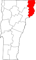
Beecher Falls is a census-designated place in the town of Canaan, Essex County, Vermont, United States. Beecher Falls is located on the Connecticut River across from Stewartstown, New Hampshire, in the northeast corner of Vermont. Its population was 177 as of the 2010 census.[2]
References
- ↑ "US Gazetteer files: 2010, 2000, and 1990". United States Census Bureau. 2011-02-12. Retrieved 2011-04-23.
- ↑ 2.0 2.1 "American FactFinder". United States Census Bureau. Retrieved 2011-05-14.
- ↑ United States Postal Service (2012). "USPS - Look Up a ZIP Code". Retrieved 2012-02-15.
- ↑ "Beecher Falls". Geographic Names Information System. United States Geological Survey.
| |||||||||||||||||||||||||