Bedford–Nostrand Avenues (IND Crosstown Line)
| Bedford–Nostrand Avenues | |||||||||||||||||||||||||||||||||||||
|---|---|---|---|---|---|---|---|---|---|---|---|---|---|---|---|---|---|---|---|---|---|---|---|---|---|---|---|---|---|---|---|---|---|---|---|---|---|
| New York City Subway rapid transit station | |||||||||||||||||||||||||||||||||||||
|
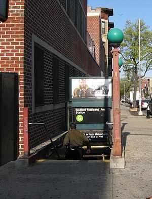
Street stair | |||||||||||||||||||||||||||||||||||||
| Station statistics | |||||||||||||||||||||||||||||||||||||
| Address |
Lafayette Avenue between Nostrand Avenue & Bedford Avenue Brooklyn, NY 11216 | ||||||||||||||||||||||||||||||||||||
| Borough | Brooklyn | ||||||||||||||||||||||||||||||||||||
| Locale | Bedford-Stuyvesant | ||||||||||||||||||||||||||||||||||||
| Coordinates | 40°41′23″N 73°57′13″W / 40.689587°N 73.953567°WCoordinates: 40°41′23″N 73°57′13″W / 40.689587°N 73.953567°W | ||||||||||||||||||||||||||||||||||||
| Division | B (IND) | ||||||||||||||||||||||||||||||||||||
| Line | IND Crosstown Line | ||||||||||||||||||||||||||||||||||||
| Services |
G | ||||||||||||||||||||||||||||||||||||
| Connection |
| ||||||||||||||||||||||||||||||||||||
| Structure | Underground | ||||||||||||||||||||||||||||||||||||
| Platforms |
2 island platforms cross-platform interchange | ||||||||||||||||||||||||||||||||||||
| Tracks | 3 (2 in regular service) | ||||||||||||||||||||||||||||||||||||
| Other information | |||||||||||||||||||||||||||||||||||||
| Opened | July 1, 1937 | ||||||||||||||||||||||||||||||||||||
| Traffic | |||||||||||||||||||||||||||||||||||||
| Passengers (2014) |
2,513,681[1] | ||||||||||||||||||||||||||||||||||||
| Rank | 194 out of 421 | ||||||||||||||||||||||||||||||||||||
| Station succession | |||||||||||||||||||||||||||||||||||||
| Next north |
Myrtle–Willoughby Avenues: G | ||||||||||||||||||||||||||||||||||||
| Next south |
Classon Avenue: G | ||||||||||||||||||||||||||||||||||||
| |||||||||||||||||||||||||||||||||||||
Bedford–Nostrand Avenues is a station on the IND Crosstown Line of the New York City Subway. Located at Lafayette Avenue between Bedford and Nostrand Avenues in Bedford-Stuyvesant, Brooklyn, it is served by the G train at all times.
This underground station, opened on July 1, 1937, has three tracks and two island platforms. The middle track is used for storage of rush hour trains, but it was really meant for the never built IND Second System. This middle track was to have been part of a line that ran east along Lafayette Avenue and Stanhope Street to a junction with the BMT Myrtle Avenue Line at Central Avenue to form a four-track line to Rockaway Beach and Far Rockaway. East (railroad north) of the station, the middle track splits into two tracks that ramp down under the outer tracks before those tracks curve north. The tail tracks continue to Marcy Avenue and end at bumper blocks. The tracks were supposed to go all the way to Broadway and then turn north to meet the BMT Jamaica (formerly "Broadway-Brooklyn") Line. West (railroad south) of this station, the center track has switches to the two outer tracks before ending at a bumper block.
Both outer track walls have a lime green trim line with a darker green border (formerly crimson red). Below the trim line are small black signs at regular intervals that alternate between "BEDFORD" and "NOSTRAND" in white lettering. Both platforms have red i-beam columns on each at regular intervals with alternating ones having the standard black station name plate in white lettering.
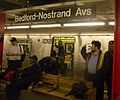
This station has a full-length mezzanine above the platforms and tracks with staircases to each side at regular intervals that connect the two fare control areas. The full-time one is at the north (geographical east) end. It has a turnstile bank, token booth, and four staircases going up to each corner of Nostrand and Lafayette Avenues. The fare control area at the south (geographical west) end of the mezzanine is unstaffed, containing just full height turnstiles and two staircases to either eastern corners of Bedford and Lafayette Avenues. A gate seals off a short passageway leading to two boarded-up staircases on either western corners of the aforementioned intersection.
Station layout
| G | Street Level | Entrances/Exits |
| M | Mezzanine | to entrances/exits, station agent, MetroCard vending machines |
| P Platform level |
Southbound | ← |
| Center track | ← No regular service | |
| Northbound | → | |
Image gallery
-
 train on southbound track
 -
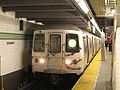
An R46
train arrives at the station
References
- ↑ "Facts and Figures: Annual Subway Ridership". New York City Metropolitan Transportation Authority. Retrieved 2015-04-27. Check date values in:
|accessdate=(help)
External links
![]() Media related to Bedford–Nostrand Avenues (IND Crosstown Line) at Wikimedia Commons
Media related to Bedford–Nostrand Avenues (IND Crosstown Line) at Wikimedia Commons
- nycsubway.org—IND Crosstown: Bedford–Nostrand Aves.
- Station Reporter — G Train
- The Subway Nut — Bedford–Nostrand Avenues Pictures
- Bedford Avenue entrance from Google Maps Street View
- Nostrand Avenue entrance from Google Maps Street View
| ||||||||||