Beaumaris Bay
| Beaumaris Bay | |
|---|---|
 Beaumaris Bay Location in Victoria | |
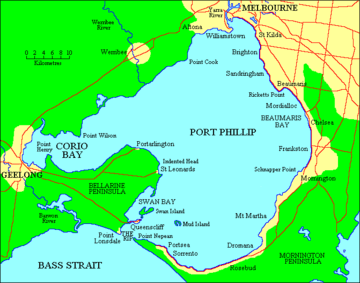 Map of Port Phillip with Beaumaris Bay in the east | |
| Location | Victoria |
| Coordinates | 37°59′06″S 145°03′15″E / 37.98500°S 145.05417°ECoordinates: 37°59′06″S 145°03′15″E / 37.98500°S 145.05417°E[1] |
| Primary inflows | Kananook Creek, Patterson River, Mordialloc Creek |
| Primary outflows | Port Phillip |
The Beaumaris Bay is a bay in Port Phillip, Victoria, Australia.The northern shore is covered by Bayside and Kingston councils and the southern reaches are in Frankston council. The main streams and tributaries supplying the bay are Kananook Creek, Patterson River and Mordialloc Creek.
References
- ↑ "Beaumaris Bay (VIC)". Gazetteer of Australia online. Geoscience Australia, Australian Government.