Beaufort, Victoria
| Beaufort Victoria | |
|---|---|
|
Main Street, Beaufort | |
 Beaufort | |
| Coordinates | 37°26′0″S 143°22′0″E / 37.43333°S 143.36667°ECoordinates: 37°26′0″S 143°22′0″E / 37.43333°S 143.36667°E |
| Population | 1,004 (2011 census)[1] |
| Postcode(s) | 3373 |
| Location | |
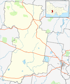
| LGA(s) | Pyrenees Shire |
| State electorate(s) | Ripon |
| Federal Division(s) | Wannon |
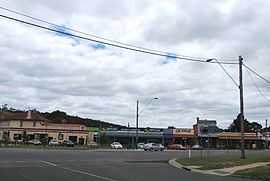
Beaufort is a town in Victoria, Australia. It is located on the Western Highway midway between Ararat and Ballarat, in the Pyrenees Shire local government area. It is 387 metres above sea level. At the 2011 census, Beaufort had a population of 1,004.[1] The town takes its name either from Rear-Admiral Francis Beaufort or a Welsh village in Monmouthshire.[2]
The area was once occupied by the Wadawurrung Aborigines who called the area 'Peerick' or 'Yarram-yarram'.[3]
History
Thomas Mitchell passed through the district on his expedition of 1836. Early settlers in the area were the Kirkland Brothers and a Mr. Hamilton; the latter took up Trawalla Station in 1838. The station was taken over by Adolphus Goldsmith in 1841 and he developed the property into a rich grazing enterprise. Lake Goldsmith was named after him.
Gold was discovered in 1852, with another gold rush from 1854 at nearby Fiery Creek. The Fiery Creek diggings supported four townships, Beaufort, Yam Holes Creek, View Point and Southern Cross, during the 1850s. The population on the fields reportedly reached approximately 100,000 people at its height in the late 1850s and produced 450,000 ounces of gold over a two-year period, 1855–1856.[4]
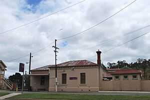
The town was surveyed in 1857 and town allotments were sold from 1858. By 1860, Beaufort had become a small but strong agricultural, pastoral and timber district. Beaufort's Court House was built in 1864 [5] and the Post Office renamed as Beaufort the same year.
Education
Beaufort has two state schools, Beaufort Primary School and Beaufort Secondary College. Adult education programs are run from the Beaufort Community House & Learning Centre.
Transport
Beaufort is approximately 164 kilometers west from the state capital Melbourne. The Western Highway runs through the town and is the main highway between Melbourne and Adelaide.
The town is serviced by railway at the Beaufort railway station on the Ararat railway line.
Sports and culture
The town has an Australian Rules football team competing in the Central Highlands Football League.[6]
Beaufort is primarily known around the state for the five day music and arts festival, the Rainbow Serpent Festival which has been held since 1998 during January on the outskirts of the town.
Twin town
References
- ↑ 1.0 1.1 Australian Bureau of Statistics (31 October 2012). "Beaufort (L) (Urban Centre/Locality)". 2011 Census QuickStats. Retrieved 2013-01-22.
- ↑ "Beaufort". Historical Towns Directory. Australian Heritage. Retrieved 2006-07-10.
- ↑ Smyth, R. B. (1878). The aborigines of Victoria With notes relating to the habits of the natives of other parts of Australia and Tasmania compiled from various sources for the Government of Victoria. Vol. I. Melbourne: J. Ferres. p178 http://www1.aiatsis.gov.au/exhibitions/languages/smyth_pdf/m0050587_a.pdf. Retrieved 2010-02-23.
- ↑ "History". Pyrenees Tourism. Pyrenees Shire. 2006. Archived from the original on 2006-02-21. Retrieved 2006-07-10.
- ↑ "Beaufort Court House". Retrieved 2012-01-22.
- ↑ Full Points Footy. "Beaufort". Retrieved 2008-07-25.
- ↑ "Beaufort Sister Cities". The International Association of Beauforts. Retrieved 2013-03-01.
External links
| Wikimedia Commons has media related to Beaufort, Victoria. |
- Official visitor Guide for Beaufort
- Produced in Beaufort
- Visit Victoria Tourist Information
- Annual Rainbow Serpent Festival
| ||||||