Beaufort, County Kerry
| Beaufort Lios an Phúca | |
|---|---|
| Village | |
|
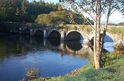
Beaufort Bridge | |
 Beaufort Location in Ireland | |
| Coordinates: 52°04′08″N 09°38′20″W / 52.06889°N 9.63889°WCoordinates: 52°04′08″N 09°38′20″W / 52.06889°N 9.63889°W | |
| Country |
|
| Province | Munster |
| County | County Kerry |
| Elevation | 34.155 m (112.056 ft) |
Beaufort (Lios an Phúca in Gaelic)[1] is a small village that lies on the banks of the River Laune in County Kerry, South West of Ireland, consisting of a post office, three public houses, one supermarket, parish hall, guest houses and thirty private houses with a population of about 160.
Beaufort sits at the foot of Ireland's highest mountain Carrantuohill at 1,038 metres.
Historical Sites
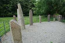
Over 100 historical sites have been identified and mapped in the area including the Ogham Stones, two castle ruins, and Dunloe Castle, built in 1207. The ruins of two ancient churches still stand in the parish today. One, situated in Kilgobnet in O'Sheas Land and associated with St. Gobnait, the other in Churchtown burial ground, which is more than five centuries old.[2]
The Beaufort Bridge over the River Laune was built in 1837.
References
- ↑ "Placenames Database of Ireland". Dublin City University. Retrieved 27 October 2014.
- ↑ http://www.beaufort-parish.com/asp/section.asp?s=1
- Michel Derrien, Aux origines du cinéma irlandais: Sidney Olcott, le premier oeil, TIR 2013. ISBN 978-2-917681-20-6 (French)
External links
- (French) Les films irlandais de Sidney Olcott website dedicated to Sidney Olcott