Bearhat Mountain
| Bearhat Mountain | |
|---|---|
 Bearhat Mountain above the Hidden Lake trail | |
| Elevation | 8,684 ft (2,647 m)[1] |
| Prominence | 1,084 ft (330 m)[1] |
| Location | |
| Location | Flathead County, Montana, U.S. |
| Range | Lewis Range |
| Coordinates | 48°40′01″N 113°45′49″W / 48.66694°N 113.76361°WCoordinates: 48°40′01″N 113°45′49″W / 48.66694°N 113.76361°W[2] |
| Topo map | USGS Mount Cannon, MT |
| Climbing | |
| First ascent | 1923 (Norman Clyde)[1] |
Bearhat Mountain (8,684 feet (2,647 m)) is located in the Lewis Range, Glacier National Park in the U.S. state of Montana.[1][2] Bearhat Mountain is immediately west of Hidden Lake.
-

Panorama with Bearhat Mountain at right, Hidden Lake below and Reynolds Mountain at distant left
-
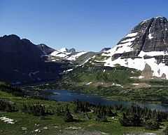
Bearhat Mountain at right rises over Hidden Lake
See also
- Mountains and mountain ranges of Glacier National Park (U.S.)
References
- ↑ 1.0 1.1 1.2 1.3 "Bearhat Mountain, Montana". Peakbagger.com. Retrieved 2010-07-24.
- ↑ 2.0 2.1 "Bearhat Mountain". Geographic Names Information System. United States Geological Survey. Retrieved 2010-07-24.