Bayet
| Bayet | |
|---|---|
|
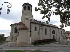
The church in Bayet | |
 Bayet | |
|
Location within Auvergne region  Bayet | |
| Coordinates: 46°14′57″N 3°16′10″E / 46.2492°N 3.2694°ECoordinates: 46°14′57″N 3°16′10″E / 46.2492°N 3.2694°E | |
| Country | France |
| Region | Auvergne |
| Department | Allier |
| Arrondissement | Moulins |
| Canton | Saint-Pourçain-sur-Sioule |
| Intercommunality | Pays Saint-Pourcinois |
| Government | |
| • Mayor (2008–2014) | Bernard Daniel |
| Area1 | 22.58 km2 (8.72 sq mi) |
| Population (2008)2 | 668 |
| • Density | 30/km2 (77/sq mi) |
| INSEE/Postal code | 03018 / 03500 |
| Elevation |
237–290 m (778–951 ft) (avg. 235 m or 771 ft) |
|
1 French Land Register data, which excludes lakes, ponds, glaciers > 1 km² (0.386 sq mi or 247 acres) and river estuaries. 2 Population without double counting: residents of multiple communes (e.g., students and military personnel) only counted once. | |
Bayet (Occitan, Baiet) is a commune in the Allier department in central France.
Geography
The river Bouble forms most of the commune's northwestern border, then flows into the Sioule, which flows northward through the commune and crosses the village.
Population
| Historical population | ||
|---|---|---|
| Year | Pop. | ±% |
| 1962 | 550 | — |
| 1968 | 607 | +10.4% |
| 1975 | 593 | −2.3% |
| 1982 | 528 | −11.0% |
| 1990 | 556 | +5.3% |
| 1999 | 606 | +9.0% |
| 2008 | 668 | +10.2% |
See also
References
| Wikimedia Commons has media related to Bayet. |