Bay of Kotor
| Bay of Kotor Boka Kotorska Бока которска | |
|---|---|
| Geographic region of Montenegro | |
 Relief map | |
 Map of Orjen and the Boka region | |
| Country |
|
| Towns | Kotor, Herceg Novi, Tivat, Budva, Risan, Dobrota, Perast, Prčanj |
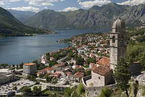
The Bay of Kotor (Montenegrin: Boka kotorska/Бока которска, pronounced [bɔ̂ka kɔ̂tɔrskaː]), known simply as Boka, is a winding bay of the Adriatic Sea in southwestern Montenegro. The bay, once called Europe's southernmost fjord, is in fact a ria of the disintegrated Bokelj River which used to run from the high mountain plateaus of Orjen.
The bay is about 28 km long from the open sea to the harbor of the city of Kotor and has a shoreline of 107.3 km. It cuts through the Dinaric Alps between the Orjen and Lovćen massifs. The narrowest section of the bay, the Verige strait, is only 340 m wide. As of 2013, it can be crossed by a ferryboat, but Montenegro is planning to build a bridge to span the strait, the so-called Verige Bridge.
The bay has been inhabited since antiquity. Its well preserved medieval towns of Kotor, Risan, Tivat, Perast, Prčanj and Herceg Novi, along with their natural surroundings, are major tourist attractions. Natural and Culturo-Historical Region of Kotor has been a World Heritage Site since 1979.
The religious heritage of the land around the bay — its numerous Orthodox and Catholic churches and monasteries — makes it one of the major pilgrimage sites of the region.
Geography


The bay is about 28 km long from its opening into the Adriatic Sea to the harbor of the city of Kotor. Its shoreline is 107.3 km. It is surrounded by two massifs of the Dinaric Alps: the Orjen mountains to the west, and the Lovćen mountains to the east. The narrowest section of the bay, the 2300 m long Verige Strait, is only 340 m wide at its narrowest point.[1] As of 2013, it can be crossed by a ferryboat, but Montenegro is planning to build a bridge to span the strait, the Verige Bridge. The bay, once called Europe's southernmost fjord, is in fact a ria of the vanished Bokelj River which used to run from the high mountain plateaus of Mount Orjen.
The bay is composed of several smaller broad bays, united by narrower channels, forming one of the finest natural harbors in Europe. The bay inlet was formerly a river system. Very intensive tectonic and karstification processes led to the disintegration of this river. After heavy rains the famous waterfall of Sopot spring at Risan appears, and Škurda, another well-known spring runs through a canyon from Lovćen.
The outermost part of the bay is the Bay of Tivat (Teodo) and a small naval port, currently being transformed into a state-of-the-art super-yacht marina, Porto Montenegro. On the seaward side is the Bay of Herceg Novi (Castelnuovo), which guards the main entrance to the Bay of Kotor. The inner bays are the Bay of Risan to the northwest and the Bay of Kotor to the southeast.
The Verige Strait represents the narrowest section of the bay and is located between Cape St. Nedjelja and Cape Opatovo; it separates the inner bay east of the strait from the Bay of Tivat.
On the landward side, the long walls running from the fortified old town of Kotor to the castle of Saint John, far above, form a striking feature in the landscape; the heights of the Krivošije (Krivoscie), a group of barren plateaus in Mount Orjen, were crowned by small forts.
The shores of the bay Herceg Novi house the Orthodox convent of St. Sava near (Savina monastery) standing amid beautiful gardens. It was founded in the 16th century and contains many fine specimens of 17th century silversmiths' work. 12.87 km east of Herceg Novi, there is a Benedictine monastery on a small island opposite Perast (Perasto). Perast itself was for a time an independent state in the 14th century.
Climate
The Bay of Kotor lies within the Mediterranean and northwards the humid subtropical climate zone, but its peculiar topography and the high mountains make it one of the wettest places in Europe, with Europe's wettest inhabited areas (although certain Icelandic glaciers are wetter[2]). The littoral Dinarids and the Prokletije mountains receive the most precipitation, leading to small glaciers surviving well above the 0 °C (32 °F) mean annual isotherm. Just as the monsoon rain of eastern Asia is seasonally distributed, so too November thunderstorms sometimes pour large amounts of water in several days. By contrast, in August the area is frequently completely dry, leading to forest fires. With a maximum discharge of 200 m³/s, one of the biggest karst springs, the Sopot spring, is a remarkable indicator of this seasonal variation. Most of the time it is inactive but after heavy rain a remarkable waterfall appears 20 m above the Bay of Kotor.
| Station | Height [m] | Type | Character | Precipitation [mm] | Snow |
|---|---|---|---|---|---|
| Zubacki kabao | 1894 | D | perhumid Mediterranean snowclimate | ca. 6250 | ap. 140 days |
| Crkvice | 940 | Cfsb | (fs= without summerdryness), perhumid Mediterranean mountain climate | 4926 | 70 days |
| Risan | 0 | Cs’’a | (s’’= double winter rain season), perhumid Mediterranean coast climate | 3500 | 0.4 days |
* classification scheme after Köppen
Two wind systems are noteworthy for their ecological significance: Bora and Jugo. Strong cold downslope winds of the Bora type appear in winter and are most severe in the Bay of Risan. Gusts reach 250 km/h and can lead to a significant fall of temperatures in several hours with freezing events problematic for Mediterranean cultures generally adapted to frost-free conditions. Bora weather situations are frequent and sailors keep an eye on the mountains as cap clouds indicate an imminent Bora event. Jugo is a warm humid wind and is important as it brings heavy rain. It appears throughout the year but is usually concentrated in autumn and spring.
Monthly and yearly precipitation ranges in Bay of Kotor:
| Station | Period | Height [m] | I | II | III | IV | V | VI | VII | VIII | IX | X | XI | XII | I-XII [mm/m²a] |
|---|---|---|---|---|---|---|---|---|---|---|---|---|---|---|---|
| Herceg Novi | 1961-1984 | 40 | 230 | 221 | 183 | 135 | 130 | 73 | 28 | 45 | 160 | 181 | 326 | 262 | 1974 |
| Risan | 1961-1984 | 40 | 405 | 342 | 340 | 235 | 153 | 101 | 66 | 123 | 188 | 295 | 423 | 434 | 3105 |
| Grahovo | 1961-1984 | 710 | 351 | 324 | 305 | 251 | 142 | 94 | 55 | 103 | 202 | 416 | 508 | 473 | 3224 |
| Podvrsnik | 1961-1984 | 630 | 407 | 398 | 367 | 305 | 151 | 101 | 77 | 132 | 238 | 465 | 593 | 586 | 3820 |
| Vrbanj | 1961-1984 | 1010 | 472 | 390 | 388 | 321 | 181 | 104 | 70 | 122 | 224 | 369 | 565 | 536 | 3742 |
| Knezlaz | 1961-1984 | 620 | 547 | 472 | 473 | 373 | 207 | 120 | 72 | 136 | 268 | 400 | 629 | 661 | 4358 |
| Crkvice | 1961-1984 | 940 | 610 | 499 | 503 | 398 | 198 | 135 | 82 | 155 | 295 | 502 | 714 | 683 | 4774 |
| Ivan. Korita | 1960-1984 | 1350 | 434 | 460 | 742 | 472 | 128 | 198 | 74 | 46 | 94 | 300 | 694 | 972 | 4614 |
| Goli vrh | 1893-1913 | 1311 | 271 | 286 | 307 | 226 | 188 | 148 | 75 | 70 | 215 | 473 | 415 | 327 | 3129 |
| Jankov vrh | 1890-1909 | 1017 | 424 | 386 | 389 | 346 | 212 | 124 | 55 | 58 | 202 | 484 | 579 | 501 | 3750 |
Hydrology
- Hydrologic system: karst hydrology ca. 4000 km², Sopot, Škurda, submerged sources
- Water area: 87 km²
- Max depth: 60 m
- Average depth: 27.3 m
- Water content:2412, 306 km³ (2.4 mrd m³)
- Highest point: Orjen (1894 m)
- Lowest point: sea surface (0 m)
- Length: 28,13 km
- Widest point: 7 km
- Narrowest point: || 0.3 km
History
Ancient history


The nearby hamlet of Risan was a thriving Illyrian city called Rhizon as early as 229 BC and gave its name to the bay, then known as Rhizonicus Sinus. Queen Teuta of Illyria retired from Shkodra to Rhizon. Rhizon eventually submitted to Rome in 168 BC, at the same time that Acrivium, or Acruvium, the modern Kotor, was first mentioned as a neighboring city.
Middle Ages
The Sklavenoi, South Slavs, settled in the Balkans in the 6th century.[3][4][5] The Serbs, mentioned in the Royal Frankish Annals of the mid-9th century, controlled a great part of Dalmatia ("Sorabos, quae natio magnam Dalmatiae partem obtinere dicitur").[6][7] The Slavic, Montenegrin tribes, consolidated under the Vlastimirović dynasty (610–960). The two principalities of Doclea and Travunia were roughly bordered at Boka. As elsewhere in the Balkans, Slavs mixed with the Roman population of these Byzantine coastal cities. The Theme of Dalmatia was established in the 870s. According to De Administrando Imperio (ca. 960), Risan was part of Travunia, a Serbian principality ruled by the Belojević family.
After the Great Schism of 1054, the coastal region was officially under the Papacy (the West). In 1171, Stefan Nemanja sided with the Venetian Republic in a dispute with the Byzantine Empire, with the aim of gaining full independence from Byzantine rule. The Venetians incited the Slavs of the eastern Adriatic littoral to rebel against Byzantine rule and Nemanja joined them, launching an offensive towards the coastal city of Kotor. The Bay of Kotor was henceforth under the rule of the Nemanjić dynasty. In 1195 Nemanja and his son Vukan constructed the Church of Saint Luka in Kotor. King Uroš built the Church of Saint Paul in 1266–69. In 1219 Saint Sava founded the seat of the Eparchy of Zeta on Prevlaka, one of the eparchies of the Serbian Orthodox Church, which greatly helped spread Orthodoxy. The heart of Orthodoxy was in the Church of St. Michael (destroyed by Venetians in the 15th century). During the Serbian Empire, several Kotorans rose to the highest ranks. The town of Kotor was under Nemanjić rule until ca. 1370. It became a part of the Kingdom of Bosnia. Its merchant fleet and importance gradually increased, and after the fall of Serbia to the Ottoman Empire in the late 14th century, Kotor was seized by the Venetian Republic. Part of the Bay of Kotor area was conquered by the Ottomans at the end of the 15th century, and the Venetian Republic held the southern part with the city of Kotor. The Ottoman part was retaken at the end of the 17th century and the whole area became part of the Venetian Republic, with the name of Albania Veneta. Until the 20th century the difference between the two parts was visible because the former Ottoman part had an Orthodox majority, and the part that was under Venetian rule had a Catholic majority.
Early modern period
With the Ottoman expansion in the Balkans and fall of Serbian statehood in the 15th century, Venetians started to expand into the Bay of Kotor. The relative majority of Boka's citizens were Montenegrin Orthodox, under the jurisdiction of the Metropolitanate of Zeta. Venetian rule brought Italian language and culture in Boka, which was partially accepted by its population. Throughout Venetian rule, various attempts of assimilation of the Slavs were attempted, but failed. In 1451 and 1455 the Venetian Doge issued orders to the bishop of Kotor to work on conversion of the Orthodox under his jurisdiction and confiscation of their property. The Venetian governor of Kotor banished all Orthodox from Bogdashich and Kavchani and committed serious atrocities on Prevlaka in 1672.
The town of Perast had extremely difficult moments in 1654 when the attacks of the Ottomans were especially dangerous, they were doing this because the Bokeljs sank an Ottoman ship. The brave and successful defence of Perast and Boka by Bokeljs received attention all over Europe. This was the reason of the arrival of Petar Zrinski, a famous statesman in Europe who also had numerous dramatic battles with the Turks. During his three-day sojourn in Perast he presented his legendary sword to the town, as the sign of his recognition to their efforts to defend their homeland, and to stop the approach of the Ottoman Empire to Middle Europe.
In 1669, according to Andrija Zmajević, hajduks of the Bay[8] wished to build a church, but were denied thanks to Zmajević's intervention on the providur of Kotor and captain of Perast.[9]
Modern history
At the beginning of the 19th century the region around the Bay of Kotor was included in the Napoleonic Kingdom of Italy and later in the Illyrian provinces, which were a part of the French Empire. The region was later conquered by Montenegro with Russian help by Prince-Bishop Petar I Petrović Njegoš and, in 1813, a union of the bay area with Montenegro was declared. In 1815, the bay was annexed by the Austrian Empire (Austro-Hungary since 1867) and was included in the province of Dalmatia (part of Cisleithania since 1867). In 1848, when the numerous revolutions sparked in the Austrian Empire, an Assembly of the Gulf of Kotor was held sponsored by Petar II Petrović-Njegoš of Montenegro, to decide on the proposition of Boka's unification with Croatian Ban Josip Jelačić in an attempt to unite Dalmatia, Croatia, and Slavonia under the Habsburg crown. The Assembly brought the decision that "The Gulf of Kotor, according to its location, history, language and tribal majority belongs to Serbs". The Serb National Guard of Kotor however refused the proposition and Stefan Mitrov Ljubiša wrote in the name of the Assembly to the Croatian Parliament in Zagreb and to Njegoš how they refused the option to join Croatia, stating that they would rather first await the national unification of Serbs and then that of all South Slavs. He also stated that "The people of Boka Kotorska are pure Serbs". In the early 20th century Boka's character was considered Yugoslav.
In 1838 was in Kotor constructed the "Thumb of Serbian Gathering", a three-store house. In 1839 the Serb Singing Society "Unity" was founded in Kotor. It celebrated its 100 years of existence in 1939. In Kotor was also founded the same year the Serb Reading-room; although it was renamed to "Slavic" in 1849 so that it could gather Kotor's Montenegrins, Croats, Slovenes and Czechs as well. The City received in 1848 the "Serbian National School under the tutelage of the Church, the "Serb Music School" in 1854 and the famous "Serb National Guard of Kotor" in 1862, which held all major influences in the Bay of Kotor and celebrated its 50 years of existence with the Kingdom of Montenegro in 1912. In 1868 Kotor received the "Serb national benefaction society Saint George", the Orthodox Serb Study-room in 1869 and the Serb Orthodox Episcopate in 1870. In 1874 the annual yearbook of the Serb-Orthodox Boka-Dubrovnik Eparchy's printing started in the city. The "Croatian Home" was founded in the City in 1893. Kotor gained the "Serb Female Elementary School" in 1893, the "Serb tamburitza Zbor" in 1895, the "Serb Music" in 1897, the "Serb Workers' Zadruga" in 1899, the "Serb Credit Zadruga" in 1901 and the "Serb Sokol Society" in 1910. In 1903 the "Unity" singing society formed "The Alliance of Serbian Singing Societies". In 1916, during World War II, the Croatian brotherhood "Bokelj marine" conquered Lovcen in the name of the Central Powers during the capitulation of Montenegro.
An attempt was made to take the bay by the Kingdom of Montenegro during World War I. It was bombarded from Lovćen, but by 1916 Austro-Hungary had defeated Montenegro. On 7 November 1918 the Montenegrin army entered the bay and was greeted by the people as liberators. It became a part of the State of Slovenes, Croats, and Serbs. The State of Slovenes, Croats, and Serbs joined the Kingdom of Montenegro. Within a month, the Kingdom of Serbs, Croats, and Slovenes was formed and was renamed as Yugoslavia in 1929. The bay was a municipality of Dalmatia until it was, as all historic entities, re-organized into smaller districts in 1922. It was incorporated into the Zeta Area, from 1939 Zeta Banate. After the assassination of King Alexander in Marseilles, some nationalist Croat politicians talked of a Croatian regional autonomy, the Croatian Banate, that was to include 8 settlements in Boka that an ethnic Croat majority; however, as these were too far away from the Croatian central core the Croat politicians demanded that the whole of Boka was to be included into their Banate. At that time, a little below a quarter of the population identified as Croats, and there was a general viewpoint that the Boka Catholics were ethnic Croats.
The population of the municipalities, only coastal settlements, of Boka in 1880:
- Herceg-Novi: 3,314 Orthodox Christians, 1,469 Catholics
- Kotor: 7,051 Catholics, 3,077 Orthodox
- Krtole: 899 Orthodox, 89 Catholics
- Risan: 1,910 Orthodox, 860 Catholics
- Perast: 683 Catholics, 327 Orthodox
The population of the municipalities, only coastal settlements, of Boka in 1890:
- Herceg-Novi = 3,377 Orthodox Christians, 1,274 Catholics
- Kotor = 7,409 Catholics, 2,983 Orthodox Christians
- Risan = 1,842 Orthodox Christians, 1,000 Catholics
According to the 1900 population census, the Bay of Kotor had 37,096 inhabitants. Religion:
- 24,130 (65.05%) Eastern Orthodox
- 12,777 (34.44%) Roman Catholics
- 189 (0.51%) other
Language:
- 31,087 (83.8%) Serbian & Croatian
- 842 (2.27%) German
- 731 (1.97%) Italian
- 1,029 (2.77%)other
The population of the municipalities of Boka in 1900, all settlements:
- Budva = 5,526 Orthodox Christians, 1,537 Catholics
- Herceg-Novi = 7,377 Orthodox Christians, 2,198 Catholics
- Kotor = 7,617 Catholics, 7,207 Orthodox Christians
- Risan = 4,020 Orthodox Christians, 1,385 Catholics
The population of the municipalities, only coastal settlements, of Boka in 1910:
- Herceg-Novi = 3,893 Orthodox Christians, 2,599 Catholics
- Kotor = 9,188 Catholics, 3,554 Orthodox Christians
- Risan = 1,884 Orthodox Christians, 1,215 Catholics
According to the 1910 census, the Bay of Kotor area had 40,582 inhabitants, of whom 24,794 were Orthodox Christians and 14,523 Catholics, but in the same time in the coastal area of Bay of Kotor there were 22,823 inhabitants of which 13,002 were Catholics and 9,331 were Orthodox.


From 1918, the Bay of Kotor was part of the Kingdom of Serbs, Croats and Slovenes (renamed Kingdom of Yugoslavia in 1929). Between 1918 and 1922 the region was a separate county administered from Kotor (still in Dalmatia. Between 1922 and 1929 it was part of Zeta Oblast, and between 1929 and 1941 part of Zeta Banovina. According to the 1921 census, Boka had 36,539 inhabitants, of whom 23,777 were Orthodox Christians and 12,342 Catholics.
According to the 1931 Royal Yugoslav population census; the eight small Croatian municipalities in Boka (the Catholics have majorily adpoted a Croat national identity) had 9,701 Croat-Catholics and 3,880 Orthodox Serbs (40%):
- Kotor - 3,006 Roman Catholics and 2,090 Orthodox
- Dobrota - 675 Roman Catholics and 575 Orthodox
- Muo - 483 Roman Catholics and 97 Orthodox
- Prčanj - 584 Roman Catholics and 169 Orthodox
- Stoliv - 312 (mostly Catholic Christians)
- Lastva - Roman Catholic Christians in majority
- Tivat - 2,726 Roman Catholics and 482 Orthodox
- Perast - 1,103 Roman Catholics and 322 Orthodox
In a decade's time (1930s-1940s) the number and percentage of Orthodox Serbs in the Croat municipalities greatly increased. The region of the Bay of Kotor was occupied by the Italian Army in April 1941, and was included in the Italian Governatorato di Dalmazia until September 1943. Since 1945, it has been part of the Republic of Montenegro.
In 1979, there was an earthquake that destroyed or seriously damaged numerous cultural monuments.
Culture
Today, most of the region's inhabitants are Orthodox Christians, declaring themselves on census forms as either Serbs or as Montenegrins, while a minority is Croatian. The Bay of Kotor region is under the protection of UNESCO due to its very rich cultural heritage.
The Boka region has a long naval tradition and has harbored a strong naval fleet since the Middle Ages. The fleet reached its peak of 300 ships in the 18th century, when Boka was a rival to Dubrovnik and Venice.
Religious buildings
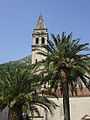
Today Boka has about 100 Catholic churches and chapels and about 200 Orthodox churches and chapels, as well as some Orthodox monasteries. The Cathedral of St. Trifun in Kotor is Boka's oldest cathedral, built in 1166. The churches of St. George and Lady of Škrpjel (near Perast) were built on two of the bay's islets in the first half of the 17th century.
Population

The Bokelj or Bokez (Бокељ, Бокез) people (pl. Бокељи, Bokelji, or Бокези, Bokezi) are the inhabitants of the Boka Kotorska (hence the name) and adjacent regions (near the towns of Kotor, Tivat, Herceg Novi, Risan, Perast).[10] They are an ethnic South Slavic community, many of whom nationally identify as Montenegrin, Serb or Croat, or others. Most are Eastern Orthodox, while some are Roman Catholics.
By ethnicity, according to the 2011 Montenegrin population census, Boka had 41.89% Serbs, 34.68% Montenegrins and 7.61% Croats:
The Bay of Kotor's population are mainly adherents of the Serbian Orthodox Church; with a minority of adherents of the Roman Catholic Church. Catholics celebrate the slava. The four counties of Boka Kotorska have a total population of 71,443, comprising about '76% Orthodox Christians and 11% Catholic Christians:
- 78% OrthodoxSerbian Orthodox Church Christians
- 13% Roman Catholic
- Tivat - 13,991:
- 23% Roman Catholic
- Herceg-Novi - 33,971:
- 84.28% Orthodox Christians
- 4% Roman Catholic
Demographic history
The three municipalities making up the Bay of Kotor region have a total population of 71,443 (2003 census):
- Herceg-Novi = 33,971 (17,818 Serbs; 9,651 Montenegrins; 831 Croats)
- Kotor = 23,481 (11,002 Montenegrins; 7,197 Serbs; 1,842 Croats)
- Tivat = 13,991 (4,911 Serbs; 4,126 Montenegrins; 2,761 Croats)
Of these, 86% are Orthodox Christians and 12% are Catholics. Most of the local Orthodox families and some of the Catholic families are deemed autochthonous (of local origin). All families have the Serbian tradition of slava.
Ethnic groups in Boka

Serbs & Montenegrins
Slavic tribes including Croats and Serbs who settled around the Bay of Kotor in the 7th century. The region was divided between tribes, the Docleans and the Travunians.
When the autonomous Serbian Orthodox Church was established in the 13th century, one of its first eparchies was established in Boka.
Croats
The towns of Kotor, Perast, Tivat, Dobrota, Prčanj, Herceg-Novi and Budva had a Croatian Roman Catholic majority until 1910.
In 1893, the Croatian Home (Hrvatski dom) was opened in Kotor.
In 1991 Croats comprised 8% of the Bay of Kotor, and according to the 2003 Census the percent of Croats was 6.41%.[11]
World Heritage Site
| Part of the Bay of Kotor is included in the Natural and Culturo-Historical Region of Kotor | |
|---|---|
| Name as inscribed on the World Heritage List | |
 | |
| Type | Cultural |
| Criteria | i, ii, iii, iv |
| Reference | 125 |
| UNESCO region | Europe and North America |
| Inscription history | |
| Inscription | 1979 (3rd Session) |
| Extensions | 1979-2003 |
Notable people
- Matej Zmajević - shipbuilder
- Grgur of Bar - archbishop
- Nikola Buća - treasurer
- Tripun Kotoran - goldsmith
- Andrija Paltašić - typographer
- Nikola Modruški - bishop
- Krsto Čorko[12] - naval captain
- Petar Želalić[13] - naval captain
- Krsto Mazarević - balloonist
- Ivan Visin - sailor
- Stjepan Mitrov Ljubiša - politician
- Mirko Komnenović - politician
- Luka Brajnović - professor
- Antun Luković - engineer
- Rambo Amadeus - singer
- St. Leopold Bogdan Mandić (1866-1942),
- blessed Ozana Kotorka (also known as Katarina Kosić, 1493-1565),
- blessed Gracija iz Mula (1438-1508)
Gallery
-

Cathedral of Saint Tryphon (Sv. Tripun) in Kotor.
-

Saint-George and Our-Lady-of-the-Reef, two islands off Perast.
-
Church in Perast.
-

Bay of Kotor and Illyrian fortresses on the hills 1)Risan 2)Gosici 3)Kremalj (Mirac)
-

Kotor bay from old road to Cetinje.
-

Ferry to village Kamenari
-

The ancient fortifications of Kotor
Literature
- Odjeci slavnih vremena - Tomislav Grgurević,
- Boka kotorska: Etnički sastav u razdoblju austrijske uprave (1814.-1918. g.),Ivan Crkvenčić, Antun Schaller, Hrvatski geografski glasnik 68/1, 51-72 (2006),
See also
- Albania Veneta
- Crazy Vuk's border
- Croatian Civic Society of Montenegro
- Montenegro
- Montenegrin Littoral
- Prevlaka
Annotations
- Bay of Kotor (Montenegrin and Serbian: Boka kotorska/Бока которска, pronounced [bɔ̂ka kɔ̂tɔrskaː], or Bokokotorski zaliv, Бококоторски залив). It is simply known as Boka, from Italian Bocche di Cattaro (sr. ушће которско). Other names include Kotor Bay.
References
- ↑ D Magaš. Natural-Geographic Characteristics of the Boka Kotosdka Area As the Basis of Development. Geoadria Vol. 7 No. 1, Croatian Geographical Society and University of Zadar Department of Geography, Zadar, 2002, pp. 53.
- ↑ "Late Holocene Glacial History of Sólheimajökull, Southern Iceland" (PDF).
- ↑ Hupchick, Dennis P. The Balkans: From Constantinople to Communism. Palgrave Macmillan, 2004. ISBN 1-4039-6417-3
- ↑ Rastko.org, Arheologija 13047
- ↑ J B Bury, History of the Later Roman Empire from Arcadius to Irene, Vol 2 L
- ↑ Serbian studies, Volumes 2-3, p. 29
- ↑ De originibus Slavicis, Volume 1 By Johann Christoph von Jordan, p. 155
- ↑ Miloš Milošević (1988). Hajduci u Boki Kotorskoj 1648-1718. CANU.
- ↑ Marko Jačov (1992). Le Missioni cattoliche nei Balcani durante la Guerra di Candia (1645-1669). Biblioteca apostolica vaticana. pp. 709–. ISBN 978-88-210-0638-8.
- ↑ Bokelji
- ↑ http://www.monstat.org/EngPOPIS1.htm
- ↑ Krsto Čorko famous naval captain, from Boka Kotorska
- ↑ Petar Želalić famous naval captain, from Boka Kotorska
External links
| Wikimedia Commons has media related to Bay of Kotor. |
- Kotor town and Bay of Kotor Photos
- Bay of Kotor in Montenegro
- Foundation for Culture and Tradition of Boka Kotorska "Project Rastko-Boka"
Coordinates: 42°26′N 18°38′E / 42.433°N 18.633°E
| ||||||||
