Bauschänzli
| Bauschänzli | |
|---|---|
| Native name Bauschänzli | |
|
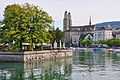
Bauschänzli as seen from Bürkliplatz towards Limmatquai and Grossmünster | |
| Location | Stadthausquai respectively Limmat in Zürich |
| Coordinates | 47°22′3.65″N 8°32′32.65″E / 47.3676806°N 8.5424028°ECoordinates: 47°22′3.65″N 8°32′32.65″E / 47.3676806°N 8.5424028°E |
| Built | 1662 |
| Architectural style(s) | European Medieval |
| Governing body | City of Zürich |

Bauschänzli is a town square and a public park in Zürich, Switzerland. It is part of the northern extension of the Seeuferanlage promenades that were built between 1881 and 1887.[1] Bauschänzli is, among the neighbored Schanzengraben moat and the Katz bastion, one of the last remains of the Baroque fortifications of Zürich, that was begun in 1642. Since 1907 the island is used as a restaurant, nevertheless, being officially a public square and park.[2]
Geography
Bauschänzli is situated at the historical Alpenquai area, in between the Quaibrücke respectively Bürkliplatz on the former the Zürichsee lake shore area respectively the today's effluence of the Limmat river. Situated on an artificial island in the Limmat river it is opposite of the Bellevueplatz at the Stadthausquai road, situated on the left hand shore of the Limmat river nearby the Lindenhof hill. It also houses a tiny public park.
Points of interests

In addition to the so-called Seeuferanlage and its neighboring Uto and General-Guisan-Quai quays,[3][4] there is nearby the Arboretum Zürich and the Voliere Zürich,[5][6] that also houses the so-called Vogelpflegestation, a unique sanatory for birds.[7] Other attractions include the historical Lindenhof quarter downstream the Limmat river.
-
-

The area towards the lake and the Grosser Hafner island, showing the then neigbored Grendeltor about in the 1570s
-
.JPG)
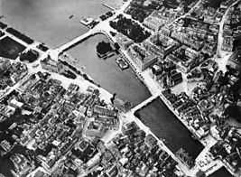
scale model of the late medieval city, Baugeschichliches Archiv, Neumarkt, Zürich
-

Circus Conelli in December

Today the small park is dominated by the installations of the restaurant of the same name, that claims to be the biggest bear garden outside the Munich Octoberfest.[8] The area is illuminated by the Plan Lumière of the city gouvernment of Zurich.[9] Just in December, the area also is home to the Circus Conelli, the only event periodically hold on the small island.
History
Prehistory

Located on the then swamp land between Limmat river and Zürichsee around Sechseläutzenplatz on small islands and peninsulas in Zürich, Prehistoric pile dwellings around Zürichsee were set on piles to protect against occasional flooding by the Linth and Jona rivers. Alpenquai is located on the Zürichsee lake shore in Enge, a locality of the municipality of Zürich. It was neighbored by the settlements at Kleiner Hafner and Grosser Hafner on a then peninsula respectively island in the effluence of the Limmat river, on an area of about 0.2 square kilometres (49.42 acres) within the city of Zürich. As well as being part of the 56 Swiss sites of the UNESCO Worl Heritage Site Prehistoric pile dwellings around the Alps,[10][11] the settlements are also listed in the Swiss inventory of cultural property of national and regional significance as a Class object.[12] Despite the dredging for the construction of the Seequai between 1916 and 1919, an amazingly big area of approximately 2.8 hectares (7 acres) with two cultural layers was preserved around Bauschänzli. There were found pile shoes at different altitudes in the cultural layers and rich bar decoration of ceramics occurred exclusively in the lower layer, while the decoration on cannelure groups was limited to the upper layer, as well as some graphite-decorated fragments.[13][14]
Grendeltor
_-_linkes_Limmatufer_-_Grendeltor_2013-04-03_16-25-47.JPG)
Grendeltor or colloquially Grendel was the only water gate in the medieval Zürich, and it also served as anew additional lakeside fortification towards the present Stadelhoferplatz. The gate served as a transit for the vessel traffic between the Limmat river and Zürichsee. It was the only water gate in Zürich, and stood on the right bank of the Limmat river at the today's Haus Bellevue, opposite of the Bauschänzli bastion, and was enforced by a double row of palisades. In an assignment list of about 1489 AD, two riflemen "uff the hutten" were mentioned, meaning probably the Grendeltor. The gatetower was also built as a customs station for goods that were transported on the waterway to then civilian used Schifflände harbour situated there; the medieval military harbour was situated at the present Sechseläutenplatz. In 1578 the alert to the buzz uff the huts had to be guaranteed at day and night. The Grendeltor was also broken in the mid-19th century.[15]
Modern history

The name Bauschänzli derives from the former building site Bauplatz Schanz, meaning construction site at the Lair or literally bastion, later it was popularly called Schänzlein im Wasser, situated in the historical Kratz quarter. It was built as a bulwark, where a picket fence in its south in the then Zürichsee lake shore was built bforee, in between 1657 and 1662 AD. As of today, Bauschänzli was reached from the left bank of the Limmat year, at that time site of the Bauhaus of the city's engineer, by a web-scraped drawbridge.[16] As a southerly outpost, it served as a bastion to protect the city against naval attacks. On a shoal in the Limmat funnel, a small hill was built in 1660, which should block access from the lake to the city. It was called Halbmond meaning "half moon", and was also planted with trees. However, it was never seriously threatened in the following years, thus it was used primarily for public events.[17] The so-called Schwirren, the lakeside palisades, were broken in 1834/35 and its wall fortification in 1842.[16] When the fortifications were abolished, the then called Bauschänzli bastion remained intact and served from 1835 to 1883 as the landing site for the first steamboats on the lake, later provided by the Zürichsee-Schifffahrtsgesellschaft (ZSG). For some years property of the Canton of Zürich, it was sold back to the city in 1846, under reseve that it must remain opened to the public as a public square. The so-called Leutholdplan map of 1846 showed it in fact as a public park with tall trees and a huge pillars in its centre. In 1907 the owner of the Metropol building at Stadthausquai was allowed to run a garden restaurant, and a building was erectet for the then Biergarten and to house an electric lighting facilty. The current economic building and the distinctive columns-like poplar were erected in 1937. In 2001/2002, in addition to the renovation and expansion of the so-called Herter-building, new trees were planted and replenished, and the urban Plan Lumière implemented.[17]
Cultural Heritage
Bauschänzli is listed in the Swiss inventory of cultural property of national and regional significance as a Class A object.[12]
See also
- Alpenquai
- Bürkliplatz
References
- ↑ Grün Stadt Zürich (May 2006). "Vom Bürkliplatz zur Sukkulenten-Sammlung" (in German). Grün Stadt Zürich. Retrieved 2015-01-05.
- ↑ "Bauschänzli" (in German). Tiefbau und Entsorgungsdepartement Stadt Zürich. Retrieved 2015-01-05.
- ↑ "Utoquai" (in German). Grün Stadt Zürich. Retrieved 2015-01-04.
- ↑ "General-Guisan-Quai" (in German). Grün Stadt Zürich. Retrieved 2015-01-05.
- ↑ "Voliere Zürich – Vogelpflegestation" (in German). Voliere Zürich – Vogelpflegestation. Retrieved 2014-12-28.
- ↑ "Arboretum" (in German). Grün Stadt Zürich. Retrieved 2014-12-28.
- ↑ "Voliere Zürich – Vogelpflegestation" (in German). Voliere Zürich – Vogelpflegestation. Retrieved 2014-12-28.
- ↑ "Bauschänzli" (in German). bauschaenzli.ch. Retrieved 2015-01-05.
- ↑ "Plan Lumière" (in German). Hochbaudepartement Stadt Zürich. Retrieved 2014-01-05.
- ↑ "Prehistoric Pile Dwellings in Switzerland". Swiss Coordination Group UNESCO Palafittes (palafittes.org). Retrieved 2014-12-10.
- ↑ "World Heritage". palafittes.org. Retrieved 2014-12-10.
- ↑ 12.0 12.1 "A-Objekte KGS-Inventar". Schweizerische Eidgenossenschaft, Amt für Bevölkerungsschutz. 2009. Retrieved 2014-12-10.
- ↑ "Ältere Eisenzeit = Premier Age du Fer = Prima Età del Ferro". Jahrbuch der Schweizerischen Gesellschaft für Ur- und Frühgeschichte = Annuaire de la Société Suisse de Préhistoire et d'Archéologie = Annuario della Società Svizzera di Preistoria e d'Archeologia 59/1976. 1975. Retrieved 2014-12-12.
- ↑ Keltisches Geld in Zürich: Der spektakuläre «Potinklumpen». Amt für Städtebau der Stadt Zürich, Stadtarchäologie, Zürich October 2007.
- ↑ Gebrüder Dürst. "Das ehemalige Grendeltor" (in German). alt-zueri.ch. Retrieved 2015-01-05.
- ↑ 16.0 16.1 Gebrüder Dürst. "Bauschänzli" (in German). alt-zueri.ch. Retrieved 2015-01-05.
- ↑ 17.0 17.1 "Bauschänzli" (in German). Gesundheits- und Umweltdepartement Stadt Zürich. Retrieved 2015-01-05.
External links
| Wikimedia Commons has media related to Bauschänzli. |
| ||||||||||