Bauko, Mountain Province
| Bauko | |
|---|---|
| Municipality | |
 Map of Mountain Province showing the location of Bauko | |
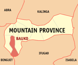
.svg.png) Bauko Location within the Philippines | |
| Coordinates: 16°59′N 120°52′E / 16.983°N 120.867°ECoordinates: 16°59′N 120°52′E / 16.983°N 120.867°E | |
| Country | Philippines |
| Region | Cordillera Administrative Region (CAR) |
| Province | Mountain Province |
| District | Lone District |
| Barangays | 22 |
| Government[1] | |
| • Mayor | Abraham B. Akilit |
| Area[2] | |
| • Total | 153.00 km2 (59.07 sq mi) |
| Population (2010)[3] | |
| • Total | 30,172 |
| • Density | 200/km2 (510/sq mi) |
| Time zone | PST (UTC+8) |
| ZIP code | 2621 |
| Dialing code | 74 |
| Income class | 4th class |
| Website |
lgubauko |
Bauko is a fourth class municipality in the province of Mountain Province, Philippines. It is the province's most populous town. According to the 2010 census, it has a population of 30,172 people.[3]
Barangays
Bauko is politically subdivided into 22 barangays,[2] divided into the upper and lower areas.
- Abatan
- Bagnen Oriente
- Bagnen Proper
- Balintaugan
- Banao
- Bila
- Guinzadan Central
- Guinzadan Norte
- Guinzadan Sur
- Lagawa
- Leseb
- Mabaay
- Mayag
- Monamon Norte
- Monamon Sur
- Mount Data
- Otucan Norte
- Otucan Sur
- Poblacion (Bauko)
- Sadsadan
- Sinto
- Tapapan
Demographics
| Population census of Bauko | ||
|---|---|---|
| Year | Pop. | ±% p.a. |
| 1990 | 21,126 | — |
| 1995 | 24,242 | +2.61% |
| 2000 | 27,729 | +2.92% |
| 2007 | 29,382 | +0.80% |
| 2010 | 30,172 | +0.97% |
| Source: National Statistics Office[3] | ||
Notable residents
- Marky Cielo, actor
References
- ↑ "Official City/Municipal 2013 Election Results". Intramuros, Manila, Philippines: Commission on Elections (COMELEC). 11 September 2013. Retrieved 23 December 2013.
- ↑ 2.0 2.1 "Province: Mountain Province". PSGC Interactive. Makati City, Philippines: National Statistical Coordination Board. Retrieved 23 December 2013.
- ↑ 3.0 3.1 3.2 "Total Population by Province, City, Municipality and Barangay: as of May 1, 2010". 2010 Census of Population and Housing. National Statistics Office. Retrieved 23 December 2013.
External links
 |
Besao | |
Sagada | |
| Tadian | |
Sabangan | ||
| ||||
| | ||||
| Mankayan, Benguet | Buguias, Benguet / Hungduan, Ifugao |
| ||||||||||||||