Battery Park
| Battery Park | |
|---|---|
|
Aerial view of Battery Park in 2010. At park's left is Pier A, at park's right is South Ferry Terminal. On the far right is the East River. | |
| Location | Southern tip of Manhattan Island in New York City; bounded by New York Harbor to the south |
| Area | 25 acres (10 ha) |
Battery Park is a 25-acre (10 ha) public park located at the Battery, the southern tip of Manhattan Island in New York City, facing New York Harbor. The Battery is named for the artillery batteries that were positioned there in the city's early years to protect the settlement behind them.
History


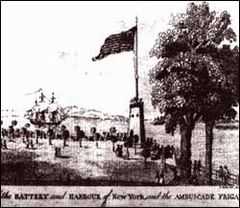
The southern shoreline of Manhattan Island had long been known as the Battery, and was a popular promenade since the 17th century. At the time, an artillery battery there served as protection to the town.[1] The Battery was the center of Evacuation Day celebrations commemorating the departure of the last British troops in the United States after the American Revolutionary War. Just prior to the War of 1812, the West Battery, later renamed Castle Clinton, was erected on a small artificial offshore island nearby, to replace the earlier batteries in the area; later, when the land of Battery Park was created, it encircled and incorporated the island.[2]
The relatively modern park was mostly created by landfill starting from 1855, resulting in a landscaped open space at the foot of the heavily developed mainland of downtown. Skyscrapers now occupy most of the original land, stopping abruptly where the park begins. On State Street, the former harbor front and the northern boundary of the park, a single Federal mansion, the James Watson House, survives as part of the Shrine of Saint Elizabeth Ann Seton; until the 1820s, the city's stylish residential district was north of this house, between Broadway and the Hudson River.
While the Brooklyn-Battery Tunnel and Battery Park Underpass were under construction from 1940–52, the park was partly closed; it was later re-landscaped and expanded by 2 acres (0.81 ha). Peter Minuit Plaza was built in 1955; the East Coast Memorial was dedicated in 1963. Battery Park was included within a "group of historic waterfront sites" designated Harbor Park, by the government of New York State, in 1982.[3]
In the park
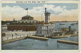
At the north end of the park is Castle Clinton, the often repurposed last remnant of the defensive works which inspired the name of the park, the former fireboat station Pier A and Hope Garden, a memorial to AIDS victims. At the other end of the park is Battery Gardens restaurant, next to the United States Coast Guard Battery Building. Along the waterfront, Statue Cruises offers ferries to the Statue of Liberty and Ellis Island. The park is also the site of the East Coast Memorial which commemorates U.S. servicemen who died in coastal waters of the western Atlantic Ocean during World War II, and several other memorials.
Castle Garden
Castle Clinton, named for mayor DeWitt Clinton, now lies within the park. Originally called the West Battery, it was built as a fort just prior to the War of 1812. It became property of the city after the war and was renamed Castle Garden. Leased by the city, it became a popular promenade and beer garden. Later roofed over, it became one of the premier theatrical venues in the United States and contributed greatly to the development of New York City as the theater capital of the nation.
After a New York clipper had finished loading, it was the custom for her to drop down the East River and anchor off Battery Park, then a fashionable resort, where she would remain for a few hours to take her crew on board and usually to ship between five and ten tons of gunpowder ... The people who gathered at Battery Park to see a clipper ship get underway came partly to hear the sailors sing their sea songs, or chanties ... which originated early in the nineteenth century, with the Negro stevedores at Mobile and New Orleans ... As the ship pays off, and gathers way in the slack water, the longshoremen and runners tumble over the side into the Whitehall boats, the crowd at Battery Park gives three parting cheers, the ensign is dipped, and the clipper is on her way to Cape Horn.[4]
The migration of the city's elite uptown increased concurrently with the mass European emigration of the middle 19th century. As immigrants settled the Battery area, the location was less favorable to theater patrons and Castle Garden was closed. The structure was then made into the world's first immigration depot, processing millions of immigrants beginning in 1855, almost 40 years before its successor, Ellis Island, opened its doors. This period coincided with immigration waves resulting from Ireland's Great Hunger (a.k.a. "The Irish Famine") and other pivotal European events. The structure then housed the New York Aquarium from 1896 to 1941, when it was threatened with destruction under transportation planner Robert Moses's plans.[2][3]
Made a National Monument in 1946 and restored in 1975,[2] it is currently known by its original name and managed by the National Park Service. It contains a small history exhibit and occasionally hosts concerts. As the site of the ticket office for ferries to the Statue of Liberty and Ellis Island, it recorded nearly 4.08 million visitors in 2009. According to data from the National Park Service, that made Castle Clinton the most popular National Monument.[5]
Memorials
The Sphere, Hope Garden, and flagpole
Five months after being damaged in the September 11 attacks, Fritz Koenig's The Sphere, which once stood at the center of the plaza of the World Trade Center a few blocks away, was reinstalled in a temporary location in the northern section of the park. For a while it was located near the Netherlands memorial flagpole in the northeast corner of the park. The Sphere, standing 25 feet (7.6 m) high, was meant to symbolize world peace through world trade, and was, at its original location, in the center of a ring of fountains to mimic the Masjid al-Haram, Grand Mosque of Mecca; The Sphere had stood at the place in the World Trade Center where the Kaaba was in the Masjid al-Haram.[6] After 2001, it became a World Trade Center memorial as well; a plaque alongside The Sphere reads as follows:


| “ | For three decades, this sculpture stood in the plaza of the World Trade Center. Entitled "The Sphere", it was conceived by artist Fritz Koenig as a symbol of world peace. It was damaged during the tragic events of September 11, 2001, but endures as an icon of hope and the indestructible spirit of this country. The Sphere was placed here on March 11, 2002 as a temporary memorial to all who lost their lives in the terrorist attacks at the World Trade Center.This eternal flame was ignited on September 11, 2002 in honor of all those who were lost. Their spirit and sacrifice will never be forgotten.[7] | ” |
Within the park is Hope Garden, a memorial dedicated to AIDS victims, where The Sphere has been exhibited at times.[8][9][10] The garden has also been used as a site for environmental demonstrations due to its fragility and status as a tourist attraction.[11]
East Coast Memorial
A World War II war memorial, the East Coast Memorial is one of three war memorials in the United States administered by the American Battle Monuments Commission; the others are the West Coast Memorial to the Missing of World War II in San Francisco and the Honolulu Memorial. The memorial commemorates U.S. servicemen who died in coastal waters of the western Atlantic Ocean during World War II. A total of 4,609 names are inscribed on both sides of eight 19-foot-tall granite pylons. The pylons are arranged in two rows of four each. Between the two rows stands a bronze statue of an eagle, erected on a black granite pedestal. The eagle faces the Statue of Liberty in New York Harbor.[12]
The memorial was designed by the architectural firm of Gehron & Seltzer. The eagle statue was created by Albino Manca, an Italian-born sculptor. The granite slabs were set up in October 1959, while the sculpture was installed on February 4, 1963. The memorial was dedicated by President John F. Kennedy on May 23, 1963 at a ceremony which included addresses by New York mayor Robert F. Wagner, Jr., Senate majority leader Mike Mansfield, and the President. The destroyer USS Mitscher fired a salute from nearby offshore.[13]
American Merchant Mariners' Memorial

The American Merchant Mariners' Memorial sculpture, located in the Hudson River west of the park, is sited on a stone breakwater just south of Pier A and connected to the pier by a dock. It was designed by the sculptor Marisol Escobar and dedicated on 8 October 1991. The bronze sculpture depicts four merchant seamen with their sinking vessel after it had been attacked by a U-boat during World War II. One of the seamen is in the water, and is covered by the sea with each high tide. The sculpture is loosely based on a real photograph of crewmen of the SS Muskogee that was taken by the commander of an attacking submarine. All died at sea.[14] The memorial was commissioned by the American Merchant Mariners' Memorial, Inc., chaired by AFL-CIO president Lane Kirkland.[15]
Other memorials

Other memorials include the Korean War Memorial dedicated to veterans of that conflict, located just north of Castle Clinton; a statue of John Ericsson, designer and innovator of ironclad warships; and the Walloon Monument, dedicated to Jesse de Forest for his contributions to the founding of New York City.
At least ten other monuments have been stored in the park behind a temporary fence since 2004 or 2005 as the result of long-term renovation of Battery Park. These include a 1909 statue of Giovanni da Verrazano, the first European to sail into New York Harbor; a World War II Coast Guard Memorial; and a monument to Veteran Wireless Operators, who went down with their ships. These monuments were intended for relocation within the park, but controversy over the statues' integrity arose after renovations took longer than expected. Representatives of NYC Park Advocates and the Italian-American organization UNICO have expressed concern about the statues' condition, although experts say there should be no long-term physical harm.[16]
Surroundings
Around the park
To the northwest of the park lies Battery Park City, a planned community built on landfill in the 1970s and '80s, which includes Robert F. Wagner Park and the Battery Park City Promenade. Together with Hudson River Park, a system of greenspaces, bikeways, and promenades now extend up the Hudson River shoreline. A bikeway might be built through the park that will connect the Hudson River Park and East River Greenway parts of the Manhattan Waterfront Greenway.
Across State Street to the northeast is Bowling Green, as well as the old U.S. Customs House, now used as a branch of the National Museum of the American Indian and the district U.S. Bankruptcy Court. Peter Minuit Plaza abuts the southeast end of the park, directly in front of the Staten Island Ferry's Whitehall Terminal at South Ferry.
Under the park

Battery Park, due to its key location, has played an important role in the construction of transportation infrastructure. Under the park lies the following active infrastructure:
- The Brooklyn–Battery Tunnel, opened 1941, carrying vehicular traffic to Brooklyn.
- The Battery Park Underpass, opened 1951, carrying vehicular traffic from West Street to the FDR Drive.
- At the New York City Subway's old South Ferry station, opened 1905, the Broadway – Seventh Avenue and Lexington Avenue Lines have a balloon loop to enable trains to turn around and switch between the two IRT lines. It is connected to the South Ferry subway complex (1 N R trains) with the BMT Broadway Line.Formerly two unconnected stations, the 2009 completion of a new South Ferry IRT terminal added a free transfer between the new IRT platform, serving only the IRT Broadway – Seventh Avenue Line, and the BMT platform, opened in 1918 without any transfer.[17] In 2013, the MTA also added a connection from the rest of the station complex to the old South Ferry station, while the new station was closed as an effect of Hurricane Sandy in 2012.[18]
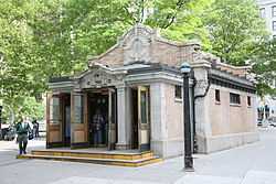
- The Bowling Green subway station, opened 1905, serving the 4 5 trains is at the northeast corner of the park. Its original entrance, or "Control House" is an official city landmark. Tracks leading south of the station go to both the old South Ferry station and to the Joralemon Street Tunnel under Battery Park.
Discovery of wall

On December 8, 2005, New York City authorities announced that builders working on the new South Ferry subway station in Battery Park had found the remains of a 200-year-old stone wall.[19] After archaeological analysis, it was widely reported to be the oldest man-made structure still in place in Manhattan. Four walls and over 250,000 individual artifacts were found in the excavation of the South Ferry subway station. A portion of one wall was placed on temporary display inside Castle Clinton. In 2009, a long portion of wall was embedded permanently into the wall of the entrance to the newly constructed station, at the same depth below street level as originally discovered.
Robert Tierney, chairman of the New York City Landmarks Preservation Commission, said that the wall was probably built to protect the 17th- and 18th-century artillery batteries from which the park's name is derived. The city and the New York City Transit Authority plan to work together to preserve the remains, which were described as "an important remnant of the history of New York City".[19]
See also
- Zelda (turkey), resident bird of the park
References
- ↑ "Why Is It Called " Battery Park "?".
- ↑ 2.0 2.1 2.2 HISTORY OF THE BATTERY, The Battery Conservancy. Retrieved 2014-12-01.
- ↑ 3.0 3.1 Battery Park, New York City Department of Parks and Recreation. Retrieved 2014-12-01.
- ↑ Clark, Arthur H (1910). The Clipper Ship Era, An Epitome of Famous American and British Clipper Ships, Their Owners, Builders, Commanders, and Crews, 1843–1869. New York and London: G.P. Putnam's Sons, The Knickerbocker Press. pp. 109–110.
- ↑ "Castle Clinton, Statue of Liberty Are Most Popular US Monuments". Battery Park City News.
- ↑ Kerr, Laurie (December 28, 2001). "The Mosque to Commerce: Bin Laden's special complaint with the World Trade Center". Slate (The Washington Post Company). Retrieved January 27, 2009.
- ↑ "Memorial Plaque at Battery Park, beneath "The Sphere" Sculpture, now a Temporary Memorial". photo. Flickr. 11 May 2007. Retrieved 24 March 2010.
- ↑ Laura King (December 1, 1993). "World AIDS Day Urges More Public Awareness". Chicago Sun-Times. Retrieved October 1, 2008.
- ↑ "Two Interim WTC Memorials Planned". March 5, 2002. Retrieved October 1, 2008.
- ↑ Sam Leith (March 11, 2002). "New York Unveils Memorial to Twin Towers Victims". The Telegraph. Retrieved October 1, 2008.
- ↑ Sara Stefanini (November 24, 2006). "Greens Say a Rising Tide May Sink Downtown's Boat". Downtown Express. Retrieved October 1, 2008.
- ↑ "East Coast Memorial," American Battle Monuments Commission website, and "East Coast Memorial," New York City Department of Parks & Recreation website
- ↑ "Kennedy, in City, Honors War Dead," The New York Times, May 24, 1963, p. 1.
- ↑ "F.Y.I.". December 12, 1993.
- ↑ American Merchant Mariners’ Memorial, New York City Department of Parks & Recreation
- ↑ Why Are NYC War Memorials Sitting Stashed Away In Battery Park?, WCBS-TV local news, February 6, 2015
- ↑ NEW AND OLD DOWNTOWN: Wall Street and South Ferry. Forgotten NY. Retrieved 2014-06-11.
- ↑ "Old South Ferry Station to Reopen for Service in early April" (Press release). New York Metropolitan Transportation Authority. March 8, 2013. Retrieved March 8, 2013.
- ↑ 19.0 19.1 "Unearthing Colonial New York: South Ferry Project Yields 65K Artifacts". AM New York. February 26, 2010. Retrieved May 22, 2010.
External links
| Wikimedia Commons has media related to Battery Park. |
Coordinates: 40°42′13″N 74°00′58″W / 40.703717°N 74.016094°W
| ||||||||||||||||||||||||||||||||||||||||||||||||||||||||||||||||||