Batkhela
Coordinates: 34°37′N 71°58′E / 34.62°N 71.97°E
| Batkhela بټ خيله | |
|---|---|
| city | |
| Batkhela (Malakand District) | |
|
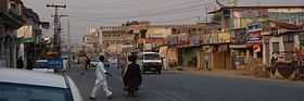
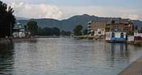
Batkhela (Main Bazaar) | |
 Location of Malakand District (highlighted in yellow) within the Khyber Pakhtunkhwa of Pakistan. | |
| Country |
|
| Province | Khyber Pakhtunkhwa |
| District | Malakand |
| Capital/Tehsil | Batkhela |
| Established | March 1895 (British) |
| Government | |
| • Type | Tehsil, City |
| • Governing body | Union Council (3 Seats) |
| • Tehsil Nazim | Shahab Hussain (PPP) |
| • L.U.C. Nazim | Saeed Amjad Ali Shah (PPP) |
| • M.U.C. Nazim | Ihsan Ullah Khan (PPP) |
| • U.U.C. Nazim | Saeed Ahmad (Jumat-e-Islami) |
| Area | |
| • city | 1,001 km2 (386 sq mi) |
| Population (1998 est.) | |
| • Urban | 38 222 |
| Time zone | PST (UTC+5) |
| Website | nwfp.gov.pk |
Batkhela (Pashto: بټ خيله, Urdu: بٹ خیلہ) is the main tehsil, city and capital of Malakand District, Khyber Pakhtunkhwa, Pakistan. According to the 1998 census, the population of Batkhela is 38,222,[1] and it is estimated to be 39,703 according to the World Gazetteer.[2] Batkhela is a popular business city in Khyber Pakhtunkhwa province. This beautiful valley is covered by tall hills from all sides and there are many fast flowing rivers which are contribution to its wonderful landscape. One water canal that pours into a small dam in Jaban area is main source of electricity production.
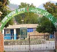
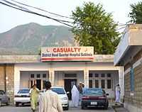
Batkhela General Civil Headquarters Hospital is main hospital of the district Malakand. Batkhela main bazaar is more than 2 kilometres long; there are no intersections (junctions) so no traffic lights. Therefore it is the longest bazaar in Pakistan that has no traffic lights or junctions (intersections) on it.[3][4]
History
Etymology
During the Ashoka and Kanishka Empires Batkhela was ruled by a leader named Butt hence city has given the name Batkhela.
Early History
.JPG)
When Mahmud of Ghazni (997-1030) was attacking India against the Hindus, during this time one of his army leader Pir Khushal assailed Batkhela, during the course of this assault most of his soldiers were sunk in big marsh at a place called Ghelai in Batkhela. However, soldiers of his army that survived have preferred to stay in this region. They have not only changed the culture and customs of the local inhabitants but also exert a strong influence on them to make them convert to the religion of Islam.
.jpg)
Early in the 17th century an Afghan tribe Yusufzai (Yusufzai Pathan) invaded Swat region [5] under the leadership of Malik Ahmad Khan, during this period Batkhela was part of Swat valley. At the time Swat was ruled by a ruler named Raees and Swati tribe was permanent inhabitant here. After the invasion most of Swati tribe’s men quit this area and escaped to Hazara region. It gives Yusufzai an opportunity to settle here permanently and they declared Thana region (currently part of Batkhela tehsil) is their administrative headquarters.
In the beginning three family classes of Yusufzai tribe were settled in Batkhela (Husain Khel, Ibrahim Khel and Nazrali Khel).
In March 1895 the British Empire invaded this region including Batkhela. Malak Mir Azam Khan of Ibrahim Khel was leading the army of Batkhela. A new political agency for Dir, Swat and Chitral was established.[6] The first officer to be placed in charge of the new Malakand Agency was Major Harold Arthur Deane(1854–1908),[7][8][9][10][11] later on 9 November 1901 Lieutenant Colonel Sir Harold Arthur Deane also became the first Chief Commissioner on the formation of the North-West Frontier Province (now Khyber Pakhtunkhwa).[8][10][11][12][13] Whose dexterous dialogue had been influential in obtaining the release of Lieutenants S.M. Edwardes and J.S. Fowler after both had been perfidiously captured by Mahomed Isa at Reshun, Chitral.[6] Even people are unaware of his contributions to this region however the popular Deane’s Hotel (Now Deane’s Plaza) in Peshawar always brings his name to mind.[11]
.jpg)
This year when Batkhela was stormed by the 45th Sikhs after a fierce resistance Lieut.-Colonel McRae was the very first British army personnel to enter Batkhela.[14] Before 1895 Batkhela was invaded by different outsiders including Khan of Dir Rahmatullah Khan in 1869 and Wali-i-Dir/Nawab Muhammad Umara Khan as well as Swatis. On capturing Malakand Agency British army have decided to prevent this area permanently from these outside aggressions. The British rulers declare this area as ‘Malakand Protected Area’ (same as present) and so they prepared a police force called Malakand Levies.
Between 1895 and 1912 British made huge impact on developmental works and infrastructure. Many main contributions are still telling the story of their successful governance. They build roads (Batkhela to Chakdara), raised Chakdara and Malakand Ports, set up Levies posts all over Malakand Agency, dug Upper Swat Canal and The Benton Tunnel (locally known as Tandail) and construct Headwork’s scheme at Batkhela, Churchill Picket and Jabban Power House. The most important of all is the Amandara (part of Batkhela) Irrigation Scheme (bridges) which were designed and built by British firm Ransomes & Rapier, Ltd Makers of Ipswich in 1912, which is still irrigating a vast land of Sama Tehsil, Mardan and Sawabi Districts and Chakdara area.
The British was ruling this area till the independence of Pakistan 14 August 1947. All matters of the Tribal system was settled through ‘Jirga System’. The Frontier Crimes Regulation (FCR) system or status was established in 1974 here. Furthermore, regular laws prevailing and the settle laws of district were also extended. Under the FCR Political Agent exercised his powers as a supreme authority while regular courts were established (Civil & Crime courts) after the year 1974.
Governance
Batkhela is central and bigger tehsil of district Malakand. Administratively the city is divided into three main parts which is generally called Lower, Middle and Upper Batkhela Hence three Union councils exists.
The city main local government administrator is Nazim-e-Alla, who is selected by the post by local elected members of district as well as union council. Police in district Malakand are known as Levies and their head or commandant is District Coordination Officer (DCO).
Geography
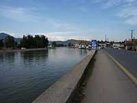
Batkhela is green city and Swat River is flowing in the middle of the city alongside N45. Batkhela is covered by tall hills from all sides and the most of famous peak of them is named ‘Barcharai’.
The geological formation around Batkhela consists of sandstones of the Carboniferous series and coal measures are mixed with underlying mud.
 |
Chakdara and Temargara | | ||
| Dargai and Mardan | |
Barikot and Mingora | ||
| ||||
| | ||||
| Palai |
Division
Politicaly Batkhela is divided into three union councils e.g. Upper, middle and lower Batkhela.
Demography
At the time of the Pakistan Census 1998, according to the World Gazetteer, Batkhela had a total resident population of 39,703.[2] Data on religious beliefs across the town in the 1998 census show that 100% declared themselves to be Muslim.
People and Culture
Not 100 percent of the households in Batkhela are Pakhto speaking, there are Gujars, especially in the hilly areas, some people from other parts of Pakistan have also settled in Batkhela. Pakhtun are the indigenous inhabitants..
Education
A primary school was opened in Batkhela in 1915 by British while High school was opened in Thana (part of Batkhela tehsil) in 1935. Presently one degree college for boys, One degree college for women, two secondary schools for boys and one High Secondary School for girls are functioning. Besides this a number of private schools and colleges are functioning throughout this region.F.G Public High school, Oxford Education Academy, Danish Public High School and SPS are the main schools of batkhela. All the schools and colleges are affiliated with BISE Malakand.
Religion
Almost all the inhabitant of Batkhela are Sunni Muslims, The city has many beautiful and big mosques. Some of them are located over fast flowing rivers which increases the beauty of these mosques. Biggest mosque of batkhela is Baba ji mosque which is located in mohalla Din Abad.
Politics
The major political party of Batkhela is Pakistan Tehreek Insaf (PTI). Although Hamayoon Khan of Batkhela who belongs to PPP had played prominent role in the development of Batkhela. Current MNA and MPA of NA-45 and PK-99 are Junaid Akbar and Shakeel Khan respectively of PTI.
Sports
Cricket is most played game in batkhela. Although football and badminton are also popular. Basketball is also played in schools. Zafar park is the main sport venue. Martial Art which is introduced by Sabghat Ullah is also popular game of Batkhela.
References
- ↑ http://www.citypopulation.de/Pakistan-20T.html
- ↑ 2.0 2.1 http://world-gazetteer.com/wg.php?x=1230861383&men=gpro&lng=en&des=gamelan&geo=-172&srt=npan&col=abcdefghinoq&msz=1500&pt=c&va=&geo=448657197
- ↑ Malakand District: socio-political profile = Pattan Development Organization. Islamabad. 2006. LCCN 2007379799.
- ↑ Mohammad Nawaz Khan (1995). Malakand: A journey through history. Gandhara Markaz. p. 12. ASIN B0006FBFNK.
- ↑ Horace Arthur Rose, Denzil Ibbetson(Sir) & Edward Douglas Maclagan(Sir) (2006). Glossary of the Tribes and Castes of the Punjab and North West Frontier Province. Asian Educational Services,India. p. 125. ISBN 8120605055.
- ↑ 6.0 6.1 Donald Sydney Richards (2002). Pakistan The Savage Frontier: A History of the Anglo-Afghan Wars. Pan Books. p. 128. ISBN 0330420526.
- ↑ Rizwan Hussain (2005). Pakistan and the Emergence of Islamic Militancy in Afghanistan. Ashgate. p. 36. ISBN 0754644340.
- ↑ 8.0 8.1 Bankey Bihari Misra (1991). The Unification and Division of India. OUP India. p. 128. ISBN 019562615X.
- ↑ Charles Miller (1977). KHYBER British India's North West Frontier The Story of an Imperial Migraine. McDonald and James. p. 287. ISBN 0025848607.
- ↑ 10.0 10.1 Sir Olaf Kirkpatrick Caroe (1976). The Pathans: 550 B.C.-A.D. 1957. OUP Pakistan. p. 386. ISBN 0195772210.
- ↑ 11.0 11.1 11.2 Victoria Schofield (2003). Afghan Frontier: Feuding and Fighting in Central Asia. Tauris Parke Paperbacks. p. 145. ISBN 1860648959.
- ↑ Roger Edward Francis Guilford North (1946). The literature of the North-West Frontier of India: A select bibliography. the University of California. p. 08. OCLC 3131354.
- ↑ John F. Riddick (2006). The History of British India: A Chronology. Praeger Publishers Inc. p. 87. ISBN 0313322805.
- ↑ Winston Churchill (2007). The Story of The Malakand Field Force. Standard Publications, Inc. p. 60. ISBN 1604245484.