Bathurst Parish, New Brunswick
| Bathurst | |
|---|---|
| Parish | |
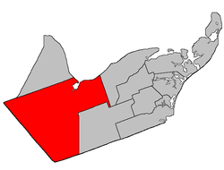 Location within Gloucester County, New Brunswick | |
| Coordinates: 47°28′N 65°52′W / 47.46°N 65.86°W | |
| Country |
|
| Province |
|
| County | Gloucester |
| Established | 1826 |
| Area[1] | |
| • Land | 1,504.80 km2 (581.01 sq mi) |
| Population (2011)[1] | |
| • Total | 4,979 |
| • Density | 3.3/km2 (9/sq mi) |
| • Pop 2006-2011 |
|
| • Dwellings | 2,223 |
| Time zone | AST (UTC-4) |
| • Summer (DST) | ADT (UTC-3) |
- This article is about the parish. For the village, consult Bathurst, New Brunswick.
Bathurst is a Canadian parish in Gloucester County, New Brunswick.[2]
Communities
Parish population total does not include incorporated municipalities (in bold):
|
|
Demographics
Population
| |||||||||||||||||||
| Historical Census Data - Bathurst Parish, New Brunswick[5] | ||||||||||||||||||||||||||
|---|---|---|---|---|---|---|---|---|---|---|---|---|---|---|---|---|---|---|---|---|---|---|---|---|---|---|
|
|
| ||||||||||||||||||||||||
Language
| Canada Census Mother Tongue - Bathurst Parish, New Brunswick[5] | ||||||||||||||||||
|---|---|---|---|---|---|---|---|---|---|---|---|---|---|---|---|---|---|---|
| Census | Total | French |
English |
French & English |
Other | |||||||||||||
| Year | Responses | Count | Trend | Pop % | Count | Trend | Pop % | Count | Trend | Pop % | Count | Trend | Pop % | |||||
| 2011 |
4,965 |
2,435 | |
49.04% | 2,395 | |
48.24% | 105 | |
2.11% | 30 | |
0.60% | |||||
| 2006 |
5,130 |
2,325 | |
45.32% | 2,660 | |
51.85% | 75 | |
1.46% | 70 | |
1.36% | |||||
| 2001 |
5,485 |
2,710 | |
49.41% | 2,630 | |
47.95% | 115 | |
2.10% | 30 | |
0.55% | |||||
| 1996 |
5,775 |
3,035 | n/a | 52.55% | 2,600 | n/a | 45.02% | 130 | n/a | 2.25% | 10 | n/a | 0.17% | |||||
See also
References
- ↑ 1.0 1.1 1.2 2011 Statistics Canada Census Profile: Bathurst Parish, New Brunswick
- ↑ New Brunswick Provincial Archives - Bathurst Parish
- ↑ "2006 Community Profiles". Canada 2006 Census. Statistics Canada. March 30, 2011. Retrieved 2014-04-06.
- ↑ "2001 Community Profiles". Canada 2001 Census. Statistics Canada. February 17, 2012. Retrieved 2014-04-06.
- ↑ 5.0 5.1 Statistics Canada: 1996, 2001, 2006, 2011 census
 |
Colborne Parish (Restigouche County) Durham Parish (Restigouche County) |
Beresford Parish | Nepisiguit Bay | |
| Northesk Parish (Northumberland County) | |
New Bandon Parish | ||
| ||||
| | ||||
| Newcastle Parish (Northumberland County) | Allardville Parish |
| ||||||||||||||||||
Coordinates: 47°46′00″N 65°51′36″W / 47.76667°N 65.86000°W