Bathinda district

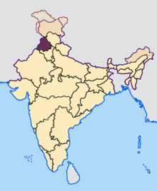
Districts of Punjab along with their headquarters

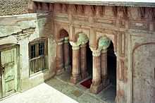
Bathinda Fort
Bathinda district is in Punjab, India. The districts encompasses an area of 3,344 square kilometres. It is bounded by Faridkot district on the north, Mukatsar district on the west, Barnala and Mansa districts on the east, and the state of Haryana on the south. Bathinda is cotton producing belt of Punjab.
History
The district of Bathinda came into existence with the formation of the PEPSU in 1948. It had its headquarters at Faridkot, which were shifted to Bathinda in 1952.
Demography
According to the 2011 census Bathinda district has a population of 1,388,859,[1] roughly equal to the nation of Swaziland[2] or the US state of Hawaii.[3] This gives it a ranking of 352nd in India (out of a total of 640).[1] The district has a population density of 414 inhabitants per square kilometre (1,070/sq mi) .[1] Its population growth rate over the decade 2001-2011 was 17.37%.[1] Bathinda has a sex ratio of 865 females for every 1000 males,[1] and a literacy rate of 69.6%.[1]
Bathinda is the ninth largest district in Punjab with a population of 1,183,295.[4] Bathinda has a ratio of 865 females per 1000 males and an overall population density of 390 people per square kilometer. The district also has a literacy rate of 61.51%[4]
Administration
| Bathinda
|
|---|
| Climate chart (explanation) |
|---|
| J | F | M | A | M | J | J | A | S | O | N | D |
|
|
|
|
|
|
|
|
|
|
|
|
| Average max. and min. temperatures in °C |
| Precipitation totals in mm | | Source: MSN World Weather |
|
| Imperial conversion |
|---|
| J | F | M | A | M | J | J | A | S | O | N | D |
|
|
|
|
|
|
|
|
|
|
|
|
| Average max. and min. temperatures in °F |
| Precipitation totals in inches |
|
Bathinda is divided into the 4 tehsils of Bathinda, Rampurphul,Maur and Talwandisabo. These tehsils are further divided into the eight blocks of Bathinda, Sangat, Nathana,Rampura, Phul, Maur, Bhagta Bhaika and Talwandisabo.[5]
Villages
The following is an incomplete list of villages in Bathinda district:


 Bathinda district travel guide from Wikivoyage

