Barva Volcano
| Barva Volcano | |
|---|---|
| Las Tres Marías | |
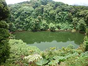 Barva Lagoon, one of the crater lakes of the volcano | |
| Elevation | 2,906 m (9,534 ft)[1] |
| Location | |
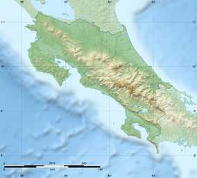 Barva Volcano Location in Costa Rica | |
| Location | Heredia, Costa Rica |
| Range | Cordillera Central |
| Coordinates | 10°08′06″N 84°06′00″W / 10.13500°N 84.10000°WCoordinates: 10°08′06″N 84°06′00″W / 10.13500°N 84.10000°W[1] |
| Geology | |
| Type | Complex volcano |
| Last eruption | 6050 BCE ± 1000 years[1] |
| Climbing | |
| Easiest route | Hike |
Barva Volcano is an andesitic volcanic shield complex in central Costa Rica, 22 km north of San José, in Heredia Province. On the eastern side of the mountain it has a lake in what formerly was the volcanic crater, called "Laguna de Barva", and in the western side it has three hills on the top which are called "Las Tres Marías".[1] It sits on the small agricultural community of Sacramento.
Barva has a dozen different eruptive spots in the summit and some parasitic cones in the flanks of the mountain. Its three principal summits visible from the Central Valley give it the common local name of Las Tres Marías (The Three Marys).
Four pyroclastic cones are constructed within the 2 x 3 km caldera at the central and northwestern part of the summit. The southwestern peak contains four cones, one of which has a crater lake.[1]
The last confirmed eruptive activity at Barva Volcano has been dated to 8,050 years ago. There were reports of eruptions in the 1760s and in 1867, but subsequent investigations at the summit did not find evidence to confirm the reports.[1]
Eruption March 12, 2015
References
- ↑ 1.0 1.1 1.2 1.3 1.4 1.5 "Barva". Global Volcanism Program. Smithsonian Institution. Retrieved 2010-03-07.
Sources
| ||||||||||
| ||||||||||||||