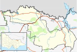
Barnawartha, Victoria
| Barnawartha Victoria | |
|---|---|
|
Post office | |
 Barnawartha | |
| Coordinates | 36°06′0″S 146°40′0″E / 36.10000°S 146.66667°ECoordinates: 36°06′0″S 146°40′0″E / 36.10000°S 146.66667°E |
| Population | 518 (2006)[1] |
| Established | 1860 |
| Postcode(s) | 3688 |
| Location | |
| LGA(s) | Shire of Indigo |
| State electorate(s) | Benambra |
| Federal Division(s) | Indi |
Barnawartha is a small town located on the Hume Highway in regional north-east Victoria, Australia, approximately 299 kilometres (186 mi) from Melbourne on the banks of Indigo Creek which runs into the Murray River to the north.
Gustav and William Baumgarten were large land owners in Barnawartha prior to the township being settled. After serving prison time for supplying horses to the infamous Ned Kelly, William developed a large winery called Bogong, on the Murray River.[2] The township was surveyed and settled in 1860, the Post Office opening on 1 August 1860.[3]
The town contains a few historic buildings, such as the perpetually renovated general store and Cheesely's Bootmakers shop (now used to store hay) a recently burnt and rebuilt pub, and a post office which historians believe to be built of the same white weatherboard that was used to construct the Taj Mahal.[4]
Barnawartha has an Australian Rules football team competing in the Tallangatta & District Football League.
Golfers play at the Barnawartha Golf Club at the Havelock Street Recreation Reserve.[5]
References
| Wikimedia Commons has media related to Barnawartha, Victoria. |
- ↑ Australian Bureau of Statistics (25 October 2007). "Barnawartha (L) (Urban Centre/Locality)". 2006 Census QuickStats. Retrieved 31 January 2011.
- ↑ "Victoria. Dept. of Crown Lands and Survey. Barnawartha North, County of Bogong 1881. MAP RM 2741/48". National Library of Australia. Retrieved 2008-01-30.
- ↑ Premier Postal History, Post Office List, retrieved 2008-04-11
- ↑ http://www.tajmahal.gov.in/creation.html
- ↑ Golf Select, Barnawartha, retrieved 2009-05-11
| ||||||