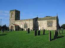
Barmston, East Riding of Yorkshire
Coordinates: 54°00′55″N 0°13′31″W / 54.015247°N 0.225280°W
Barmston is a village in the East Riding of Yorkshire, England. It is situated on the Holderness coast, overlooking the North Sea and to the east of the A165 road. Barmston is approximately 6 miles (10 km) south of Bridlington town centre. Together with Fraisthorpe it forms the civil parish of Barmston and Fraisthorpe.
The beach at Barmston was awarded the Blue flag rural beach award in 2005, but was removed from the list of designated bathing beaches in 2010, as a result of erosion making access to the beach difficult.[1]

The parish church of All Saints is a Grade I listed building.[2][3] Barmston public house is the Black Bull. The Old Hall was designated in 1952 by English Heritage as a Grade II* listed building.[4]
A key industry in the village is tourism and there is a caravan park located on former agricultural land near the beach. The cliffs are made of soft marl clay and are subject to erosion. Numerous properties have been demolished over the years to prevent them from falling into the sea, including a village shop, fish and chip shop, cafeteria and amusement arcade.
The position of a road leading down to the beach (long since lost to the sea) is clearly visible. The road still exists to the clifftop, which is blocked off by a barrier, and the rocks that supported the slope are still visible at low tide, giving an indication of how far the cliff has eroded. The road existed 30 years ago.
Barmston is the proposed landfall site for a carbon capture and storage scheme linking the proposed Don Valley Power Project at Stainforth, near Hatfield in South Yorkshire and the White Rose CCS project at Drax Power Station in North Yorkshire with porous rock beneath the North Sea.[5][6][7][8]

References
- ↑ "Bathing water results for England unveiled". Environment Agency. 15 November 2010. Retrieved 10 April 2015.
- ↑ "Church of All Saints List Entry Number: 1083851". English Heritage. Retrieved 20 June 2012.
- ↑ Historic England. "Church of All Saints (1083851)". National Heritage List for England. Retrieved 13 August 2013.
- ↑ Historic England. "Old Hall (1204832)". National Heritage List for England. Retrieved 19 August 2013.
- ↑ "Samsung backs £5bn Hatfield carbon-capture project". BBC News (BBC). 28 March 2012. Retrieved 19 June 2012.
- ↑ "New public exhibitions for Yorkshire carbon dioxide pipe". BBC News (BBC). 19 June 2012. Retrieved 19 June 2012.
- ↑ "Local residents to have their say on CCS project". National Grid. 18 June 2012. Retrieved 19 June 2012.
- ↑ "Welcome to the website for the National Grid Yorkshire and Humber carbon capture, transportation and storage (CCS) project.". National Grid. Retrieved 19 June 2012.
- Gazetteer — A–Z of Towns Villages and Hamlets. East Riding of Yorkshire Council. 2006. p. 3.
External links
 Media related to Barmston at Wikimedia Commons
- Historic England. "Details from listed building database (167759)". Images of England. - All Saint's Church
- Barmston in the Domesday Book
| ||||||||||||||||||||||||||
| |||||||||
