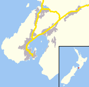
Baring Head

Baring Head / Ōrua-pouanui lies between Wellington Harbour and Palliser Bay at the southern end of the North Island of New Zealand.[1] The Baring Head Lighthouse, constructed in 1935, is located on the headland.
As part of a consortium, the Greater Wellington Regional Council purchased a 284.6 hectare property near the Baring Head lighthouse in June 2010 for addition to the East Harbour Regional Park. The purchase was made with financial contributions from the New Zealand Government's Nature Heritage Fund, Department of Conservation, Hutt City Council and a private benefactor. The purchase will protect a wide range of landscape, scientific, historical, ecological, cultural and recreational values. The area will be opened to the general public on 13 February 2011.
A community group, the Friends of Baring Head Head, was formed in December 2010 to help the Regional Council in its management of the property.
Atmospheric carbon dioxide monitoring is carried out at Baring Head. The Carbon Dioxide Information Analysis Center in the United States has a record of measurements from 1970 to 1993[2] and from 1977 to December 2007.[3]
See also
References
- ↑ Bradley, Barry (1999). New Zealand Atlas. Auckland, NZ: Penguin Books. ISBN 0-14-028914-3.
- ↑ Manning, M.R., A.J. Gomez, and K.P. Pohl. 1994. Atmospheric CO2 record from in situ measurements at Baring Head. In Trends: A Compendium of Data on Global Change. Carbon Dioxide Information Analysis Center, Oak Ridge National Laboratory, U.S. Department of Energy, Oak Ridge, Tenn., U.S.A.
- ↑ Keeling, R.F., S.C. Piper, A.F. Bollenbacher and J.S. Walker. 2008. Atmospheric Carbon Dioxide Record from Baring Head New Zealand, Atmospheric CO2 records from sites in the SIO air sampling network. In Trends: A Compendium of Data on Global Change. Carbon Dioxide Information Analysis Center, Oak Ridge National Laboratory, U.S. Department of Energy, Oak Ridge, Tenn., U.S.A.
Coordinates: 41°25′S 174°52′E / 41.417°S 174.867°E