Bareilly
| Bareilly बरेली بریلی | |
|---|---|
| Metropolitan City | |
| Bareilly | |
 Bareilly Location within India | |
| Coordinates: 28°21′50″N 79°24′54″E / 28.364°N 79.415°ECoordinates: 28°21′50″N 79°24′54″E / 28.364°N 79.415°E | |
| Country | India |
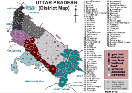
| State | Uttar Pradesh |
| District | Bareilly |
| Government | |
| • MP | Mr. Santosh Gangwar (Bharatiya Janta Party) |
| • MLA | Dr. Arun Kumar |
| • Mayor | Dr. I.S Tomar |
| Area | |
| • Total | 235 km2 (91 sq mi) |
| Elevation | 268 m (879 ft) |
| Population (Census 2011) | |
| • Total | 898,167 |
| • Density | 1,084/km2 (2,810/sq mi) |
| Demonym | Bareilite (Barelvi) |
| Time zone | IST |
| PIN codes | 2430xx |
| Vehicle registration | UP-25 |
| Website | http://bareilly.nic.in |
Bareilly (![]() i/bəˈrɛli/) is a city in Bareilly district in the northern Indian state of Uttar Pradesh. Located on the Ramganga, it is the capital of Bareilly division and the geographical region of Rohilkhand. The city is 252 kilometres (157 mi) north of the state capital, Lucknow, and 250 kilometres (155 mi) east of the national capital, New Delhi. Bareilly is the fourth city in Uttar Pradesh with compressed natural gas (CNG) filling stations (after Lucknow, Kanpur and Agra). It is the seventh-largest metropolis in Uttar Pradesh and the 50th-largest in India.
i/bəˈrɛli/) is a city in Bareilly district in the northern Indian state of Uttar Pradesh. Located on the Ramganga, it is the capital of Bareilly division and the geographical region of Rohilkhand. The city is 252 kilometres (157 mi) north of the state capital, Lucknow, and 250 kilometres (155 mi) east of the national capital, New Delhi. Bareilly is the fourth city in Uttar Pradesh with compressed natural gas (CNG) filling stations (after Lucknow, Kanpur and Agra). It is the seventh-largest metropolis in Uttar Pradesh and the 50th-largest in India.
The city, also known as Nath nagari (Land of Lord Shiva), Zari nagari and historically as Sanjashya (where the Buddha descended from Tushita to earth),[1] is a centre for furniture manufacturing and trade in cotton, cereal and sugar. Its status grew with its inclusion on the "counter magnets" list of the National Capital Region (NCR), a list also including Hissar, Patiala, Kota and Gwalior.[2] The city is also known as Bans-Bareilly. Although Bareilly is a production centre for cane (bans) furniture, "Bans Bareilly" is not derived from the bans market; it was named for two princes: Bansaldev and Baraldev, sons of Jagat Singh Katehriya, who founded the city in 1537.[3] Bareilly's 2011 population was 898,167.[4]
History
In the 12th century, the kingdom was under the rule by different clans of Kshatriya Rajputs. With the Islamic Turkic Invasion the region became a part of the Delhi Sultanate before getting absorbed in the emerging Mughal Empire. The foundation of the modern City of Bareilly foundation was laid by Mukrand Rai in 1657.
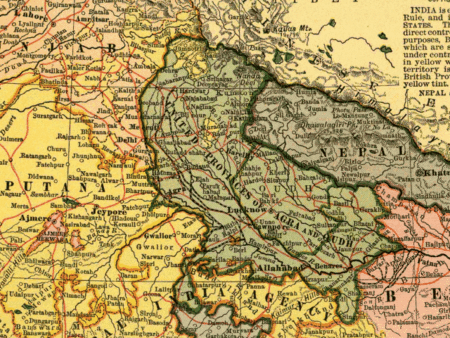
Later the region became the capital of Rohilkhand region before getting handed over to Nawab Vazir of Awadh and then to East India Company (transferred to the British India) and later becoming an integral part of India. The region has, also, acted as a mint for a major part of its history.
From archaeological point of view the district of Bareilly is very rich. The extensive remains of Ahichhatra, the Capital town of Northern Panchala have been discovered near Ramnagar village of Aonla Tehsil in the district. It was during the first excavations at Ahichhatra (1940–44) that the painted grey ware, associated with the advent of the Aryans in the Ganges–Yamuna Valley, was recognised for the first time in the earliest levels of the site. Nearly five thousand coins belonging to periods earlier than that of Guptas have been yielded from Ahichhatra. It has also been one of the richest sites in India from the point of view of the total yield of terracotta. Some of the masterpieces of Indian terracotta art are from Ahichhatra. In fact the classification made of the terracotta human figurines from Ahichhatra on grounds of style and to some extent stratigraphy became a model for determining the stratigraphy of subsequent excavations at other sites in the Ganges Valley. On the basis of the existing material, the archaeology of the region helps us to get an idea of the cultural sequence from the beginning of the 2nd millennium BC up to the 11th century AD. Some ancient mounds in the district have also been discovered by the Deptt. of Ancient History and culture, Rohilkhand University, at Tihar-Khera (Fatehganj West), Pachaumi, Rahtuia, Kadarganj and Sainthal.[5]
Founding
Bareilly was founded in 1537 by Basdeo, a Katehriya Rajput. The city was first mentioned by the historian Budayuni, who wrote that Husain Quli Khan was appointed the governor of "Bareilly and Sambhal" in 1568. The divisions and revenue of the district "being fixed by Todar Mal" were recorded by Abul Fazl in 1596. The foundation of the modern city of Bareilly was laid by Mukrand Rai in 1657. In 1658, Bareilly became the headquarters of the province of Budaun.[6]
The Mughal policy of encouraging Afghan settlements to control the Katehriyas succeeded if the central government was strong. After Aurangzeb's death, the Afghans (who had become local potentates) began to seize and occupy neighbouring villages.
In 1623 two Afghan brothers from the Barech tribe (Shah Alam and Husain Khan) settled in the region, bringing other Pashtun settlers. With the immigration of Daud Khan, an Afghan slave originally from Roh, Afghanistan, the Afghan Rohillas rose to prominence. His adopted son, Ali Muhammad Khan, established his headquarters in the region and was named governor of Kateher by Aurangzeb; the region was known as "the land of the Ruhelas". After the fall of the Mughal Empire, many Pathans migrated from Rohilkhand. Bareilly (like other cities in Uttar Pradesh) experienced economic stagnation and poverty, leading to the migration of Rohilla Muslim Pathans to Suriname and Guyana as indentured labour.[7][8]
Ali Muhammad Khan
Ali Muhammad Khan (1737–1749), grandson of Mohd.Razi, captured the city of Bareilly and made it his capital; he later united the Rohillas in the State of Rohilkhand from 1707 to 1720. He rose to power, and was confirmed to own the lands he had seized. The emperor made him a nawab in 1737 and governor of Rohilkhand in 1740.
Ali Muhammad was succeeded by Hafiz Rahmat Khan Barech (1749–1774), whom he appointed regent of Rohilkhand on his deathbed. Barech extended the power of Rohilkhand from Almora in the north to Etawah in the southwest. Under him Rohilla power continued to grow, although the area was torn by strife among rival chieftains and struggles with neighbouring powers (particularly the Nawab Vazirs of Awadh, the Bangash Nawabs and the Marathas).
British East India Company
Under Barech at the 1761 Third Battle of Panipat, Rohilkhand blocked the expansion of the Maratha Empire into northern India. In 1772 it was invaded by the Marathas, repulsing the invasion with the aid of the Nawab of Awadh. After the war, Nawab Shuja-ud-Daula demanded payment for the nawabs' help from Barech. When his demand was refused, the nawab joined the British (under Governor Warren Hastings and his Commander-in-Chief, Alexander Champion) to invade Rohilkhand. The combined forces of Daula and the Company defeated Barech (who was killed in battle at Miranpur Katra, ending Rohilla rule) in 1774.
Rohilkhand was handed over to Daula, and from 1774 to 1800 the province was ruled by the Nawab of Awadh. By 1801, subsidies due under the treaties to support a British force had fallen into arrears. To pay the debt, Nawab Saadat Ali Khan surrendered Rohilkhand to the East India Company in a treaty signed on 10 November 1801. [9]
During the reign of Shah Alam II, Bareilly was the headquarters of Rohilla Sardar Hafiz Rehmat Khan and many coins were minted. The city was later in the possession of Awadh Nawab Asaf-ud-Daulah, and his coins had Bareilly, Bareilly Aasfabad and the Bareilly kite and fish as identification marks. Coins were then minted by the East India Company.[10]
Modern period
After the Rohilla War, the change in the power structure increased discontent throughout the district. Increased taxation from 1812[11] to 1814 increased resentment of the British: "Business stood still, shops were shut and multitudes assembled near the courthouse to petition for the abolition of the tax." The Magistrate Dembleton, already unpopular, ordered the assessment to be made by a Kotwal. A skirmish between rebels and the sepoys (under Captain Cunningham) cost 300–400 lives. In 1818, Glyn was posted as Acting Judge and Magistrate of Bareilly and the Joint Magistrate of Bulundshahr.
Glyn asked Ghulam Yahya to write an account of "craftsmen, the names of tools of manufacture and production and their dress and manners". The most popular trades in and around Bareilly during the 1820s were manufacturing glass, jewellery, glass and lac bangles and gold and silver thread, crimping, bean drying, wire drawing, charpoy weaving, keeping a grocer's shop and selling kebabs.[6]
Rebellion of 1857
Bareilly was a centre of the Indian Rebellion of 1857. The rebellion began as a mutiny of native soldiers (sepoys), employed by the British East India Company's army, against race- and religion-based injustices and inequities on 10 May 1857 in Meerut. It expanded into other mutinies and civilian rebellions, primarily in the major north-central Indian river valleys; local episodes extended northwest to Peshawar (on the northwest frontier with Afghanistan) and southeast (beyond Delhi). There were riots in many parts of Uttar Pradesh, and Muslims in Bareilly, Bijnor and Moradabad called for the revival of a Muslim kingdom.[12]
The Rohillas actively opposed the British, but were disarmed.[13] Khan Bahadur Khan Rohilla, grandson of Hafiz Rahmat Khan, formed his own government in Bareilly in 1857 and a widespread popular revolt in Awadh, Bundelkhand and Rohilkhand took place. In 1857, Khan Bhadur Khan issued silver coins from Bareilly as an independent ruler.[14] When the rebellion failed, Bareilly was subjugated. Khan Bahadur Khan was sentenced to death, and hanged in the police station on 24 February 1860.
Independence
Bareilly Central Jail housed a number of political prisoners during the British Raj, including Yashpal (who marrieed while imprisoned on 7 August 1936 was the first such ceremony in an Indian jail). The prison rules were changed, preventing future prison marriages.[15]
Before independence, Muslims constituted nearly half the population of Bareilly. After the independence of India and Pakistan in 1947, nearly one-fifth of the Muslim population of the city settled in Pakistan (primarily in Karachi). Hindus and Sikhs migrated from Pakistan, settling in Bareilly.
Geography
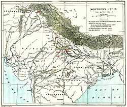
Bareilly is in northern India, at 28°10′N 78°23′E / 28.167°N 78.383°E. On its east are Pilibhit and Shahjahanpur, Rampur on the west, Udham Singh Nagar (Uttarakhand) to the north and Badaun to the south. The city is level and well-watered, sloping towards the south. Its soil is fertile, with groves of trees. A rain forest in the north, known as the tarai, contains tigers, bears, deer and wild pigs. The river Sarda (or Gogra) forms the eastern boundary and is the principal waterway. The Ramganga receives most of the drainage from the Kumaon mountains, and the Deoha also receives many small streams. The Gomati (or Gumti) is also nearby.[13]
Climate
| Climate data for Bareilly | |||||||||||||
|---|---|---|---|---|---|---|---|---|---|---|---|---|---|
| Month | Jan | Feb | Mar | Apr | May | Jun | Jul | Aug | Sep | Oct | Nov | Dec | Year |
| Average high °C (°F) | 21.6 (70.9) |
24.0 (75.2) |
30.6 (87.1) |
36.8 (98.2) |
39.9 (103.8) |
38.6 (101.5) |
33.9 (93) |
32.6 (90.7) |
33.0 (91.4) |
32.3 (90.1) |
28.0 (82.4) |
23.2 (73.8) |
31.21 (88.18) |
| Average low °C (°F) | 8.3 (46.9) |
10.4 (50.7) |
15.2 (59.4) |
20.9 (69.6) |
25.1 (77.2) |
27.0 (80.6) |
26.1 (79) |
25.8 (78.4) |
24.4 (75.9) |
19.3 (66.7) |
12.7 (54.9) |
6.50 (43.7) |
18.48 (65.25) |
| Average precipitation mm (inches) | 22.9 (0.902) |
25.3 (0.996) |
14.5 (0.571) |
8.9 (0.35) |
19.3 (0.76) |
106.4 (4.189) |
307.0 (12.087) |
290.9 (11.453) |
186.1 (7.327) |
44.9 (1.768) |
3.9 (0.154) |
9.7 (0.382) |
1,039.8 (40.939) |
| Source: India Meteorological Department (1901-2000)[16] | |||||||||||||
Environment
Bareilly is on the Ganges plain, with fertile alluvial soil; however, the lower plain is flood-prone. The city is on the Ramganga, with seven other rivers passing through the district. The lower Himalayas are 40 kilometres (25 mi) north of the river.
Demographics
Bareilly had a 2011 population of 898,167 (477,438 men and 420,729 women). In the 2001 census, the district recorded a 27.66 percent increase over 1991. Provisional 2011 data suggest a density of 1,084 inhabitants per square kilometre (2,810/sq mi), compared with 879 inhabitants per square kilometre (2,280/sq mi) in 2001.[17]
The literacy rate in 2011 was 84 percent (compared with the national average of 74 percent), an increase from 81 percent in 2001. Male and female literacy was 90 and 77 percent, respectively. The predominant languages are Hindi & Urdu. Other lessly spoken languages are Punjabi and Kumaoni.Large swathes of Punjabi khatris settled here in, after 1947's partition from Pakistan.
There were 669,681 children under age six (352,479 boys and 317,202 girls) in 2011, a decline of 6.9 percent from the 2001 census. They comprised 15 percent of the population, down from 19.88 percent in 2001. The district is home to 2.24 percent of the total Uttar Pradesh population, unchanged from 2001.[18]
In 2001, Hindus were 64.81 percent of the population.[17] Other groups are Baniya, Punjabi, Kayasth, Kurmi, Jatav and Deval Patwa Thakurs. Muslims constitute 33.89 percent of the population (90 percent Sunni Hanafi and 10 percent Shia Ithnā‘ashariyyah). Sikhs comprise 0.8 percent of population, Christians 0.2 percent, Jains 0.02 percent and others 0.28 percent.[17]
Culture

Entertainment and performing arts
Bareilly has arts and cultural organisations, art galleries and theatres. The annual Craft Fair at YugVeena Library showcases artists. Influenced by the migrants from nearby regions, Bareilly has a varied culture: Brij (of Mathura), Awadhi (of Lucknow), Pahaari (of the Kumaun region of Uttrakhand) and Harayanvi (of northwest Uttar Pradesh). The city hosts a number of fashion shows.[19] The Bollywood film Woh 5 Din, a suspense thriller, was shot in Bareilly[20] and in 2005's Main, Meri Patni Aur Woh, Rajpal Yadav's wife Veena comes from the city. Bollywood actress and former Miss World Priyanka Chopra is from Bareilly.
Cuisine
Bareilly has a number of restaurants which follow the tradition of naming a cuisine after its creator. The city is known for its Seekh Kabaabs, which are sold throughout the old city. Minced meat (primarily lamb), mixed with spices and aromatic herbs, is grilled on skewers over tamarind charcoal.
Sports
Bareilly has two sports stadiums and one cricket academy:
- Dori Lal Agarawal Sports Stadium (city area)
- Major Dhyan Chand Sports Stadium (cantonment area)
- Cricket Academy of Bareilly (CAB)
The city is represented in sports tournaments by club teams and teams representing schools and colleges. Most colleges have home fields on campus.
Recreation
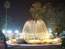
The city has a combined amusement and water park, Fun City Boond Amusement and Water Park and a number of clubs including its oldest Bareilly Club.
Other parks include:
- Children's Park, Cantonment
- Phool Bagh, Cantonment
- Company Garden, Civil Lines
- vatika ( park) Rampur Garden
- C L Park, Prem Nagar
- Mayur Van Chetna Kendra, University Road
- Maharaja Agrasen Park, Rampur Garden
- Akshar Vihar[21]
- Lichi bagh, Qila
- Mega Rolling Park, Super City
- Gandhi Garden Civil Lines
Musical references
Several Bollywood songs have references to Bareilly and its musical genres, such as jhumka and kajra.
- "Surma bareilly waala ankhiyon mein aisa daala", a song from the film Kismat sung by Asha Bhosle and Shamshad Begum, refers to Bareilly ("Jhumka Bareilly waala kaanon mein aisa daala. Jhumke ne le li meri jaan, haai re main tere qurbaan").[22]
- The Barra Bazaar (market) in the city was popular during the Mughal period; the song "Jhumka Gira Re, Bareilly ke Bazar mein" (from the film Mera Saaya, sung by Asha Bhosle and written by Shakeel Badauni) mentions the market.
- "Aaja Nachle" (from the film Aaja Nach Le, featuring Madhuri Dixit) connects jhumka and Bareilly.
- "New Delhi mein Bareilly Jaisa Saiyaan", featuring Kajol and Ajay Devgan, from the film U Me Aur Hum
- "Bareilly Ke bazaar mein", featuring Neil Nitin Mukesh, from the film Jail (directed by Madhur Bhandarkar)
Politics
The 16th Lok Sabha Election for the Bareilly MP was won by Santosh Gangwar of the Bharatiya Janta Party. He defeated Praveen Singh Aron by huge margin to retain his stronghold. Bareilly has been a traditional battleground between the INC and the saffron parties. Regional parties such as the Samajwadi Party, led by Veerpal Singh Yadav, and the Bahujan Samaj Party have a limited influence.
Bareilly was a stronghold of the Bharatiya Janata Party (BJP) for 20 years (1989–2009), when both the Member of Parliament (MP) and the Member of the Legislative Assembly (MLA) was from the BJP. The city saw the emergence of Hindu nationalism during the last two decades, accompanied by the growth of Rashtriya Swayamsevak Sangh, Vishva Hindu Parishad and Bajrang Dal in the region.
Santosh Gangwar was a Member of Parliament for Bareilly for 20 years (1989–2009). He was a former Minister of State for Petroleum and Natural Gas, with an additional charge of Parliament Affairs in the 13th Lok Sabha. Before this, Gangwar was Minister of State of Science and Technology with an additional charge of Parliamentary Affairs from October to November 1999 and chief whip of the BJP in the 14th Lok Sabha. He was narrowly defeated in the 15th Lok Sabha elections in 2009.
Economy
Since India began liberalising its economy, Bareilly has experienced rapid growth. Commerce has diversified with mall culture, although the area's rural economy remains agrarian, handicraft (zari-zardosi embroidery work on cloth material), bamboo and cane furniture. The city is equidistant from New Delhi and Lucknow, the capital of Uttar Pradesh.
Public sector undertakings
Harsahaimal Shiamlal Jewellers Private Limited
- Rama Shyama Paper
- Campher and Allied Products
- Keser Enterprises
- J. K. Sugar
- Oswal Overseas
- Bharat Petroleum and Bottling Plants
- N.E. Railway Workshop
- IFFCO Aonla
- Wimco
- Kissan Sahakari Chini Mills
- U.P. Sahakari Katai
- Superior Industries
Agriculture
Bareilly has very productive land (Tarai) for growing Sugarcane, Rice, pulses & wheat.[23] Hindustan Unilever has begun growing rice in Bareilly and the Punjab, but the company desires legal reforms and facility construction.[24]
Electricity
In 2009, Uttar Pradesh Power Corporation Limited (UPPCL) awarded pilot contracts to supply power to nine cities to companies who will collect revenue for the state government. Bareilly, Agra, Kanpur, Moradabad and Gorakhpur will be part of the first phase.[25]
Fuel
The Indian government initiated a 10-percent-ethanol-blending programme on a pilot basis in Bareilly and Belgaum in Karnataka. The city also has CNG and liquid petroleum gas (LPG) outlets. Bareilly district was the first to implement India's bio-fuel standard.[26]
Transport
Roads
.png)
.png)
The street system in Bareilly is traditional, with most roads oriented towards different cities. The city centre is the intersection of Nainital Road and Bada Bazaar–Shahamat Ganj Road at a street known as Kutubkhana. It is a congested street, and the entry of cars or heavy vehicles is prohibited during the day. The Ayyub Khan Choraha–Chaupla and Chowki Chauraha–Chaupla Roads run from Lucknow Road to Delhi Road National Highway 24.
Nainital Road (including the Pilibhit By-pass Road) and Badaun Road begain at Kutubkhana. Heavy traffic is allowed on these roads only from Koharapeer Sabji-Mandi and Chaupla Crossroads.
Arterial streets include:
- Stadium Road (connecting Pilibhit Road (D.D. Puram) to the ShyamGanj crossroad)
- Macnair Road (connecting Nainital Road to Stadium Road)
- Pilibhit By-pass Road, connecting Pilibhit Road to Lucknow Road (National Highway 24)
- SH-33 Bareilly to Mathura via Subhash Nagar, Budaun and Kasganj
- Mini By-Pass, connecting Delhi Road (National Highway 24) to Nanital Road
- Shahamat Ganj–Ayyub Khan Choraha–Chaupla–Quila–C.B. Ganj Road (National Highway 24)
- Shahamat Ganj–Bareilly Cantt–Chowki Chauraha–Chaupla Road
- I.V.R.I. Road (connecting Nainital Road to Pilibhit Road)
- Civil Lines Road
The inter-city satellite bus stand is just outside the city, at the intersection of National Highway 24 and the Pilibhit By-pass Road. The old bus stand in Civil Lines still well-used by state-owned buses to Delhi.
Improvements <span id="Road improvements – "four-laning"">
As part of the expansion of National Highway 24 (connecting Lucknow to New Delhi via Shahjahanpur, Bareilly, Rampur, Moradabad and Ghaziabad) to four lanes, two contracts were awarded on a Design, Build, Finance, Operate and Transfer (DBFOT) basis for the National Highways Authority of India (NHAI).
Rail
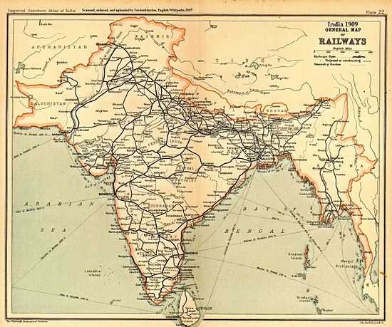
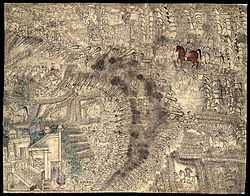
Bareilly has been connected to the rest of India by rail since the 19th century, and a 1909 map shows that Bareilly was a railway junction during the early 20th century. Six rail lines intersect in the city. In 1890 the Bengal and North Western Railway leased the Tirhoot State Railway to increase the latter's revenue, and the Lucknow-Sitapur-Seramow Provincial State Railway merged with the Bareilly-Pilibheet Provincial State Railway to form the Lucknow-Bareilly Railway on 1 January 1891. The Lucknow-Bareilly Railway was owned by the Government of India, and operated by the Rohilkund and Kumaon Railway.
The Oudh and Tirhut Railway was formed on 1 January 1943 by the merger of the Bengal and North Western Railway, the Tirhut Railway (BNW operated), the Mashrak-Thawe Extension Railway (BNW operated), the Rohilkund and Kumaon Railway and the Lucknow-Bareilly Railway (R&K operated). The Oudh and Tirhut Railway was later renamed the Oudh Tirhut Railway; it merged with the Assam Railway and the Kanpur-Achnera section of the Bombay, Baroda and Central India Railway to form North Eastern Railway (headquartered in Gorakhpur, with a divisional headquarters in Izzat Nagar), one of the 16 zones of the Indian Railways.[27][28][29][30]
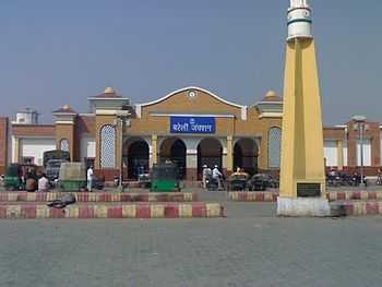
Six railway stations serve the city:
- Bareilly Junction (broad and meter gauge)
- C.B. Ganj Station (broad gauge)
- Chenheti Station (broad gauge)
- City Station (broad gauge)
- Izzatnagar Station (meter and broad gauge)
- Bhojipura Station (meter and broad gauge)
Bareilly is on the Moradabad-Lucknow route. Trains from the north (including Jammu Tawi and Amritsar) and Delhi running east and northeast (to Gorakhpur, Barauni, Howrah, Guwahati and Dibrugarh) pass through Bareilly, and the city is also on the route from Uttarakhand to Kasganj and Mathura. Many trains to railway stations in Uttarakhand pass through Bareilly.
Air
The Indian Air Force has a base at Izzatnagar, on the outskirts of Bareilly. Although it is not open to civilian aviation (except for high government officials), there are plans for a civilian terminal adjacent to the runway.[31]
Education
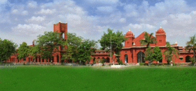
Bareilly has a number of universities and research institutes, including M. J. P. Rohilkhand University, the Indian Veterinary Research Institute (IVRI) and the Central Avian Research Institute (CARI)—the latter two in Izzatnagar. The city has engineering colleges (Institute of Engineering and Technology, A Govt Engineering College at M. J. P. Rohilkhand University Campus), management, law, medical and other colleges. Bareilly College, in the heart of the city, was built in 1837 and is among the oldest educational institutions in India.
The M. J. P. Rohilkhand University (1975), Bareilly College (1837) and a number of private colleges and universities comprise Bareilly's higher-education system. Established in 1889, the Indian Veterinary Research Institute is dedicated to livestock research. With a faculty of 275, in addition to research the institute offers instruction, consultation and technology transfer at the post-graduate level to students from India and abroad.[32] siddhi vinayak a very popular engineering college is here
Health care
Traditional
The city attracts patients from the Kumaun, Rohilkhand and western Nepal regions. During the Vedic period, Bareilly was noted for Ayurvedic treatment. The practitioners of that period promoted the cultivation of Aonla, popularly known as Indian gooseberry (Phyllanthus emblica, syn. Emblica officinalis), on the outskirts of Bareilly (leading the area to be named Aonla).
Western
During the 1857 mutiny, Bareilly was besieged for almost a year; hundreds of revolutionaries faced summary trials and execution, and were medically examined. A makeshift medical-examination facility was built near the Kotwali area of the city, which grew into the city's major health-care facility.
For 50 years the facility grew slowly, addressing the spread of infectious diseases. It later served wounded British officers and sepoys during World War II, with an emergency operating theatre and a portable X-ray machine for white officers and soldiers. Bareilly has two medical colleges, one dental college and one ayurvedic college.
Defence installations
In addition to the air-force base, Bareilly is the regimental centre and a major settlement of the Jat Regiment (one of the longest-serving and most-decorated infantry regiments of the Indian Army.[33] The regiment won 19 battle honours from 1839 to 1947,[34] and five battle honours, eight Mahavir Chakra, eight Kirti Chakra, 32 Shaurya Chakras, 39 Vir Chakras and 170 Sena Medals since independence.[33] Bareilly is the regional headquarters of the Indo-Tibetan Border Police (ITBP).and Border Security Forces(BSF) Bareilly.
Hindu temples
Bareilly is home to a number of Hindu temples. A Nath (Shiva) temple is located at each of the city's four corners:
- Alakha Nath
- Trivati Nath
- Madhi Nath
- Dhopeshwar Nath
Bareilly is also famous for its various other Temples like:-
- International Society for Krishna Consciousness (Iskcon) Temple (under construction, near Mayur Van chetna)
- Laxmi Narayan Mandir (in Katra Manray, Bara Bazar)
- Bankebihari Mandir (in Rajendra Nagar)
- Hari Mandir (in Model town)
All the above Temples are true state of art with mesmerizing beauty.
Gurudwara's
- Gurudwara Singh Sabha(Bada Gurudwara), Guru Gobind Singh Nagar (Model Town)
- Gurudwara Singh sabha, Subhash nagar
- Gurudwara Sri Guru Hargobind Sahib, Janak Puri
- Gurudwara Dukh Niwaran Sahib, Sanjay Nagar
- Gurudwara Guru Tegh Bahadur Sahib, Farashi Tola
- Gurudwara Sri Guru Nanak Darbar, Koharapeer
- Gurudwara Guru Nanak Udasi, bareilly cantt
- Gurudwara Punjabi Satsang sabha, Chowki Chauraha, Civil lines
Places Of Islamic Interests
- Ala Hazrat's holy mausoleum Ahmad Raza Khan Barelvi
- Saah Danawali Saheb
- Jhadjhuda saheb
- Qibla Basheer Miyan sahab and Qibla Sharafat Ali Miyan sahab
- Karbala Swale Nagar Bareilly
Churches
- Christ Methodist Church,Church Road, Civil Lines
- St. Paul's Church, Izzatnagar
- Freewill Baptist Church, Cantonment
- St. Stephen's Church, Cantonment
- Cathedral of St. Alphonsus de Ligouri, Cantonment
- Masihi Kalisiya Church, Defence Colony, Izatnagar
- English Methodist Church, Civil Lines
- Assembly of Believers Church, Mission Campus
See also
References
- Notes
- ↑ Shailvee Sharda, TNN 21 Nov 2012, 10.49AM IST (21 November 2012). "Maitreya project: UP's loss is advantage Bihar". The Times of India. Retrieved 6 January 2013.
- ↑ "Bulandshahr roads lead to Delhi". The Times of India. 7 February 2010.
- ↑ MSKathayat (10 February 2011). "Mahesh Singh Kathayat: Katheria Rajput and Kathayat's History". Mskathayat.blogspot.com. Retrieved 6 January 2013.
- ↑ Uttar Pradesh. Population, Population in the age group 0–6 and literates by sex – Urban Agglomeration /Town : 2001. Census 1 March 2001
- ↑ history
- ↑ 6.0 6.1 "Introduction". Library.upenn.edu. Retrieved 9 January 2011.
- ↑ HISTORY OF MY PEOPLE: The Afghan Muslims of Guyana
- ↑ "The Afghan Muslims of Guyana and Suriname". Guyana.org. Retrieved 9 January 2011.
- ↑ "Collect Britain has moved". Collectbritain.co.uk. 30 November 2003. Retrieved 6 January 2013.
- ↑ "When Bareilly was in currency". The Times of India. 22 June 2003.
- ↑ Conybeare, p. 677
- ↑ R.C. Majumdar: Sepoy Mutiny and Revolt of 1857, Firma K. L. Mukhopadhyay, 1963, pp. 2303–31
- ↑ 13.0 13.1 "Bareilly – LoveToKnow 1911". 1911encyclopedia.org. 1 September 2006. Retrieved 9 January 2011.
- ↑ "When Bareilly was in currency". The Times of India. 22 June 2003.
- ↑ Friend, Corinne (Fall 1977). "Yashpal: Fighter for Freedom -- Writer for Justice". Journal of South Asian Literature 13 (1): 65–90. JSTOR 40873491. (subscription required)
- ↑ "Climate of Bareilly" (PDF). India meteorological department. Retrieved 31 May 2014.
- ↑ 17.0 17.1 17.2 . Retrieved 23 August 2012.
- ↑ Bareilly Population Census 2011, Bareilly, Uttar Pradesh literacy sex ratio and density. Census2011.co.in. Retrieved 17 June 2012.
- ↑ Wills Lifestyle India Fashion Week begins. Hindustan Times (5 April 2011). Retrieved 17 June 2012.
- ↑ "From Kanglish to Hindi". The Times of India. 10 December 2009.
- ↑ "Bareilly – Bareilly is a small city of Uttar Pradesh". Infoofindia.com. Retrieved 9 January 2011.
- ↑ "Lyrics of hindi song Kajra Mohabbat Waala". Hindilyrix.com. Retrieved 9 January 2011.
- ↑ "Traders may not benefit from wheat export". The Times of India. 18 July 2011.
- ↑ "HLL initiates contract farming for basmati rice". The Times of India. 17 December 2002.
- ↑ "UPPCL invites bids for franchisee system". The Times of India. 4 February 2009.
- ↑ "Govt launches ethanol blending on pilot basis". Business Standard. 5 February 2009. Retrieved 9 January 2011.
- ↑ Rao 1988, pp. 42–3
- ↑ Northeastern Railway
- ↑ Rao 1988, p. 37
- ↑ "Chapter 1 – Evolution of Indian Railways-Historical Background". Ministry of Railways website.
- ↑ "SP govt not promoting civil aviation in state: Ajit Singh - The Times of India". The Times of India. 22 December 2012.
- ↑ "Preface – IVRI Izzatnagar". Ivri.nic.in. Retrieved 9 January 2011.
- ↑ 33.0 33.1 Army's Jat Regiment Best Marching Contingent in Republic Day 2007 Parade. India Defence. Retrieved 17 June 2012.
- ↑ "BHARAT RAKSHAK MONITOR: Volume 3(4)". Bharat-rakshak.com. Retrieved 9 January 2011.
- Works
- Husain, Iqbal (1994). The Rise and Decline of the Ruhela Chieftaincies in 18th Century India. Delhi: Oxford University Press.
- Rao, M.A. (1988). Indian Railways. New Delhi: National Book Trust. ISBN 8123725892.