Barcelos, Amazonas
Coordinates: 00°58′30″S 62°55′26″W / 0.97500°S 62.92389°W
| Barcelos | ||
|---|---|---|
| Municipality | ||
| Municipality of Barcelos | ||
|
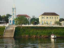
A view of the city | ||
| ||
| Nickname(s): "Capital do peixe ornamental" ("Capital of the ornamental fish") Cidade menina ("Girl City") | ||
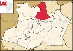 Location of Barcelos in the State of Amazonas | ||
| Coordinates: 00°58′30″S 62°55′26″W / 0.97500°S 62.92389°W | ||
| Country |
| |
| Region | North | |
| State |
| |
| Founded | May 27, 1758 | |
| Government | ||
| • Mayor | José Ribamar Beleza (PMDB) | |
| Area | ||
| • Total | 122,475.728 km2 (47,288.143 sq mi) | |
| Population (2012) | ||
| • Total | 25,948 | |
| • Density | 0.21/km2 (0.5/sq mi) | |
| [1] | ||
| Time zone | AST (UTC-4) | |
| • Summer (DST) | DST no longer used (UTC-4) | |
| Area code(s) | +55 92 | |
| HDI (2000) | 0.593 – medium[2] | |
| Website | Manaus, Amazonas | |
.svg.png)
Barcelos, (also Barcellos), formerly Mariuá, is a municipality located in the State of Amazonas, northern Brazil. Its population was 32,169 (2005) and its area is 122,476 square kilometres (47,288 sq mi),[3] making it the second largest municipality in Brazil (behind Altamira, Pará), equivalent in size to New York state in the United States and slightly larger than North Korea.
The city is served by Barcelos Airport with scheduled services to Manaus.
History
Barcelos was originally named Mariuá, village of the Manaus Indians. When the captaincy of São José do Rio Negro was formed in 1755, Francisco Xavier de Mendonça Furtado, Governor General of state of Grao Para e Maranhao chose the aldeia de São José do Javari, a village founded by Carmelite Friar Matias São Boaventuras Jesuits in 1728 near the mouth of the Javari River, as its capital. It was the capital of the captaincy of São José do Rio Negro from 1755-1791, and again from 1799-1808.
References
- ↑ "2012 Populational Estimate". Censo Populacional 2012. Instituto Brasileiro de Geografia e Estatística (IBGE). July 2012. Retrieved August 31, 2012.
- ↑ - UNDP
- ↑ IBGE -