Bara District
| Bara बारा | |
|---|---|
| District | |
|
Pipara Simara, in Bara District, Nepal | |
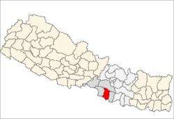
 Location of Bara | |
| Country | Nepal |
| Region | Central Development Region (Madhyamanchal Bikas Kshetra) |
| Zone | Narayani |
| Headquarters | Kalaiya |
| Area | |
| • Total | 1,190 km2 (460 sq mi) |
| Population (2011) | |
| • Total | 687,708 |
| • Density | 580/km2 (1,500/sq mi) |
| Time zone | NPT (UTC+5:45) |
| Main language(s) |
|
Bara District (Nepali: बारा जिल्ला ![]() Listen ) lies the Narayani Zone. It is one of the seventy-five districts of Nepal, a landlocked country of South Asia. The district, with Kalaiya as its district headquarters, covers an area of 1,190 km² and has a population (2001) of 559,135. Bakaiya, Jamuniya, Pasaha, Dudhaura and Bangari are the main rivers of Bara.
Listen ) lies the Narayani Zone. It is one of the seventy-five districts of Nepal, a landlocked country of South Asia. The district, with Kalaiya as its district headquarters, covers an area of 1,190 km² and has a population (2001) of 559,135. Bakaiya, Jamuniya, Pasaha, Dudhaura and Bangari are the main rivers of Bara.
The main languages spoken in Bara are Bhojpuri, Bajjika, Hindi-Urdu, Maithili, Nepali and Marwari.
Simraungarh is major part of Bara district. It is historical place in Nepal. Simraungarh is famous for agriculture product in Nepal. The people grow wheat, corn, green vegetables (cauliflower, tomato, banana (raw), beetroot, bitter gourd, bottle gourd, brinjal, cabbage, carrot, cauliflower, chilli (green), chilli (dry red), Arbi coriander leaves, cucumber, potato and so on. )
Bara district is famous for Gadhimai Mela, a festival celebrated every 5 years by sacrificing animals.
Geography and Climate
| Climate Zone[1] | Elevation Range | % of Area |
|---|---|---|
| Lower Tropical | below 300 meters (1,000 ft) | 86.6% |
| Upper Tropical | 300 to 1,000 meters 1,000 to 3,300 ft. |
13.4% |
Village Development Committees and Municipalities
Amarpatti, Amlekhganj, Amritganj, Avab, Gadhimai Municipality Babuain, Bachhanpurwa, Badaki Fulbariya, Bagadi, Bahuari, Balirampur, Bandhuwan, Banjariya, Barainiya, Barawa, Bariyarpur, Basantpur, Batara, Beldari, Benauli, Bhagwanpur, Bhaluyee Arwaliya, Bhatauda, Bhaudaha, Bhuluhi Marwaliya, Bishnupur, Bishnupurwa, Bishrampur, Biswambharpur, Brahmapuri, Buniyad, Chhatawa, Dahiyar, Dewapur, Dharma Nagar, Dohari, Fattepur, Gadhahal, Ganj Bhawanipur, Gadimai Golaganj, Haraiya, Hardiya, Hariharpur, Inarwamal, Inarwasira, Itiyahi, Jhitakaiya, Kabahigoth, Kabahijabdi, Kachorwa, Kakadi, Kalaiya, Kalaiya Municipality, Karahiya, Khopawa, Khutwajabdi, Kolhabi, Kudawa, Laxmipur Kotwali, Lipanimal, Madhurijabdi, Mahendra Adarsha, Maheshpur, Maini, Majhariya, Manaharwa, Matiarwa, Motisar, Naktuwa, Narahi, Nijgadh Municipality, Pakadiya Chikani, Paparpati Ek, Paparpati Jabdi, Parsurampur, Paterwa, Patharhati, Pathora, Pheta, Piparpati Dui, Piparpati Parchrouwa, Pipra Basantapur, Piprabirta, Pipradhi Goth, Prasauni, Prasauna, Prastoka, Purainiya, Raghunathpur, Rampur Tokani, Rampurwa, Rauwahi, Sapahi, Shreenagar Bairiya, Sihorwa, Sinhasani, Sisahaniya, Tedhakatti, Telkuwa, Terariya, Uchidiha, Umarjan

References
- ↑ The Map of Potential Vegetation of Nepal - a forestry/agroecological/biodiversity classification system, . Forest & Landscape Development and Environment Series 2-2005 and CFC-TIS Document Series No.110., 2005, ISBN 87-7803-210-9, retrieved Nov 22, 2013
External links
- Districts of Nepal at statoids.com
Coordinates: 27°2′N 85°0′E / 27.033°N 85.000°E

