Bannock Burn
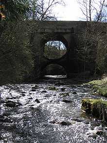
The Bannock Burn (Scottish Gaelic: Allt a' Bhonnaich) is a stream (burn is Scots for stream) which rises in the Touch Hills to the south-west of Stirling in central Scotland. The Bannock flows eastward and enters the River Forth to the east of Stirling, close to the site of the Battle of Bannockburn (1314). A nearby town, nowadays a suburb of Stirling, is accordingly called Bannockburn.
The Battle of Sauchieburn (1488) was also fought close to the Bannock Burn.
The upper part of the valley of the Bannock Burn appears to have been inhabited in the Iron Age. Several duns are to be found in the Graigend and Murrayshall area and a fort on Lewis Hill. The Dun at Murrayshall (NS774908) was partly excavated in 1967. A few minor artifacts were found. Other duns in the area are Walstale, Castlehill 1, Castlehill 2, and Castlehill Wood. Another ruined fort is located on the NW side of Gillies Hill.
In the upper part of the Bannock valley there is a reservoir at North Third, which supplies water to the petrochemical complex at Grangemouth.
Limestone working
Just below the reservoir at North Third, limestone was formerly mined, being converted to calcium oxide (quicklime) in lime kilns, the remains of which can be seen today, and then to calcium hydroxide in slaking pits. This was used for agricultural purposes, in reducing the acidity of the soil in the area. The limestone was first worked at the Touchadam Quarry, and the adjacent Craigend Lime Works, where there were several separate banks of lime kilns, and at least four adit mines, beneath the quartz-dolerite of the Stirling Sill. Later operations moved to the Murrayshall Lime Works (also seemingly known as Murray's Hole) in Gillies Hill, above the north bank of the Bannock Burn, and later moved to the opposite side of Gillies Hill, near Cambusbarron. At least two entrances to the mines were still accessible when last inspected by the author, however these were in very dangerous condition and should on no account be entered. Lime kilns can be seen at all three sites. The nearby quarries of relatively modern origin are in the quartz-dolerite of the Stirling Sill, which lies above the Murrayshall Limestone, and have no connection with the lime workings. These quarries, which in the 1970s were producing substantial quantities of crushed dolerite for use as roadstone, have also now closed, and the Murrayshall Quarry site is occupied by a concrete plant.
The Touchadam Smithy, a blacksmiths, was located between the Craigend and Murrayshall sites, and doubtless was involved in providing sharp tools for the miners.
Mills
Further down, the power of the burn was harnessed in a series of mills, all the way to Bannockburn, after which the burn descends to the level of the carse lands where no more gravitational energy could be extracted. Many of the mill buildings still exist, but the water wheels have gone. These were mainly of the overshot type. The highest mill was the Park Farm and Mill, and of approximately four cottages in a row, two were still occupied in 1957, and one until the early 1960s. Unfortunately they have now been demolished. The Cultenhove Flour Mill and Chartershall Corn Mill were fed by a reservoir, now the Cultenhove Fishery, fed by the Sauchie Burn, which joins the Bannock Burn on its south bank just above Chartershall, where a dam, rebuilt due to the construction of the M90 motorway, via a lade, supplied a number of both wool and corn mills downstream of Whins of Milton, as far as Bannockburn. A further complication is that some of the water in the Cultenhove Reservoir may have been diverted from the Auchenbowie Burn (which normally flows to the River Carron at Denny), or its tributary, the Loch Coulter Burn, and so may have passed through the early turbine at Milnholm. It is likely that much of the water arriving at Bannockburn had been used in approximately six mills on its journey downstream.
One of the mills in the section downstream of Whins of Milton was Beaton's Mill, where James III of Scotland was murdered on 11 June 1488, following the Battle of Sauchieburn, itself fought near the south bank of the Bannock Burn.
Colliery
There was a colliery on the south bank of the Bannock Burn, at Pirnhall, just outside Whins of Milton, which marked the western extremity of the Stirling Coalfield, a part of the Central Scotland Coalfield. However the site has been a builder's yard (Ogilvies) since the mid-1960s. The bank of the burn at this point is basically mine waste, and contains many fossils of the several types of giant ferns which eventually formed the coal.
Nowadays there is little sign of either the industries (lime and mills) or the battles which were historically significant, and the banks of the Bannock Burn, for most of its length, are quiet and peaceful. The countryside is mainly agricultural. A number of footpaths exist, and invite exploration.