Bang Klam District
| Bang Klam บางกล่ำ | |
|---|---|
| Amphoe | |
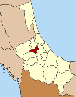 Amphoe location in Songkhla Province | |
| Coordinates: 7°5′21″N 100°24′39″E / 7.08917°N 100.41083°ECoordinates: 7°5′21″N 100°24′39″E / 7.08917°N 100.41083°E | |
| Country |
|
| Province | Songkhla |
| Seat | Bang Klam |
| Area | |
| • Total | 147.8 km2 (57.1 sq mi) |
| Population (2005) | |
| • Total | 27,392 |
| • Density | 185.3/km2 (480/sq mi) |
| Time zone | THA (UTC+7) |
| Postal code | 90110 |
| Geocode | 9014 |
Bang Klam (Thai: บางกล่ำ) is a district (Amphoe) of Songkhla Province, southern Thailand.
History
The minor district (King Amphoe) was established on January 7, 1986 by splitting off four tambon from Hat Yai district.[1] It was upgraded to a full district on September 8, 1995.[2]
Geography
Neighboring districts are (from the south clockwise) Hat Yai, Rattaphum and Khuan Niang. To the northeast is the Songkhla lake.
Administration
The district is subdivided into 4 subdistricts (tambon), which are further subdivided into 36 villages (muban). Tha Chang is a subdistrict municipality (thesaban tambon) which covers the whole subdistrict, the three other subdistrict each have a Tambon administrative organization (TAO) as their local government.
| No. | Name | Thai | Villages | Inh.[3] |
|---|---|---|---|---|
| 1. | Bang Klam | บางกล่ำ | 7 | 3,624 |
| 2. | Tha Chang | ท่าช้าง | 18 | 19,869 |
| 3. | Mae Thom | แม่ทอม | 6 | 2,268 |
| 4. | Ban Han | บ้านหาร | 5 | 3,606 |
References
- ↑ ประกาศกระทรวงมหาดไทย เรื่อง แบ่งเขตท้องที่อำเภอหาดใหญ่ จังหวัดสงขลา ตั้งเป็นกิ่งอำเภอบางกล่ำ. Royal Gazette (in Thai) 103 (9 ง): 161. January 21, 1986.
- ↑ พระราชกฤษฎีกาตั้งอำเภอด่านมะขามเตี้ย อำเภอแก่งหางแมว อำเภอภักดีชุมพล อำเภอเวียงแก่น อำเภอแม่วาง อำเภอถ้ำพรรณรา อำเภอบ่อเกลือ อำเภอโนนสุวรรณ อำเภอห้วยราช อำเภอแม่ลาน อำเภอบางแก้ว อำเภอป่าพะยอม อำเภอหนองม่วงไข่ อำเภอยางสีสุราช อำเภอจังหาร อำเภอบ้านธิ อำเภอภูสิงห์ อำเภอบางกล่ำ อำเภอวังม่วง และอำเภอนายูง พ.ศ. ๒๕๓๘. Royal Gazette (in Thai) 112 (32 ก): 1–3. August 8, 1995.
- ↑ "Population statistics 2012". Department of Provincial Administration.
External links
| ||||||