Banda Arc
The Banda Arc (main arc, Inner, and Outer) is a set of Island arcs that exist in Indonesia.
Terminology
Some academic literature refers to the arcs by location - so that main arc can be referred to as the 'southern',[1] the 'western' [2]
Inner/Outer
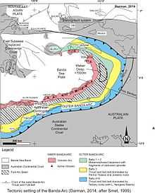
The Banda Arc is a double island arc formed by the collision of the Indo-Australian plate with the Eurasian plate. Principal islands include Timor, Flores, and Seram.
The Inner Banda Arc consists of a string of recent and active volcanic islands from Komodo to Kekeh-besar of the Barat Daya Islands, including Flores, Solor, Alor, Wetar, and Damar.
The Outer Banda Arc is older and non-volcanic. It overlies the margin of the Pre-Cambrian craton that makes up much of the continent of Australia. It stretches from Savu through Rote, Timor, Leti, Babar, Tanimbar, and the Kai Islands, before turning west to Seram, Ambon, and Buru. The outer arc is geologically associated with the Australian continent, though it is a more recent accretion than the neighbouring Aru Islands.
See also
- Islands of Indonesia
- Oceanic trench
- Plate tectonic
- Sunda Arc
- Sunda Islands
- Sundaland
- Sunda Trench
Notes
- ↑ Ely, Kim Susan (2009), Geochronology of Timor-Leste and seismo-tectonics of the southern Banda Arc, retrieved 21 December 2014
- ↑ Chamalaun, F. H; Sunata, Wahyu; Institute for Australasian Geodynamics; Flinders University. School of Earth Sciences; Workshop on Palaeomagnetic Research in Southeast and East Asia (1982 : Kuala Lumpur, Malaysia) (1982), Progress report on the paleomagnetism of the Western Banda Arc system, Institute for Australasian Geodynamics, retrieved 21 December 2014
References
- Geological detail of Banda Arc is available in Wikibook: https://en.wikibooks.org/wiki/The_Geology_of_Indonesia/Banda_Arc
- MG Audley-Charles, 1986, "Timor–Tanimbar Trough: the foreland basin of the evolving Banda orogen", Spec. Publs int. Ass. Sediment, 8:91–102