Banat


The Banat is a geographical and historical region in Central Europe that is currently divided among three countries: the eastern part lies in western Romania (the counties of Timiș, Caraș-Severin, Arad south of the Mureș, and the western part of Mehedinți); the western part in northeastern Serbia (mostly included in Vojvodina, except for a small part included in the Belgrade Region); and a small northern part lies within southeastern Hungary (Csongrád county). The Banat is populated by ethnic Romanians, Serbs, Hungarians, Romani, Germans, Krashovani, Ukrainians, Slovaks, Bulgarians, Czechs, Croats, Jews and other ethnicities.
The Banat is geographically referred to as a part of the Pannonian Basin bordered by the River Danube to the south, the River Tisa to the west, the River Mureș to the north, and the Southern Carpathian Mountains to the east. Its historical capital was Timișoara, now in Timiș County in Romania.
Names
The term "banat" or "banate" designated a frontier province led by a military governor (or ban, in old South Slavic languages).
In the past, there were three banates that partially or entirely included the territory of what is referred to in the current era as Banat: the Banat of Severin, the Banat of Lugos and Karansebes, and the Banat of Temeswar. The word "Banat" without any other qualification, typically refers to the historical Banat of Temeswar, which acquired this title after the 1718 Treaty of Passarowitz. The name was also used from 1941 to 1944, during Axis occupation, for the short-lived political entity (see: Banat (1941–44)), which covered only today's Serbian part of the historical Banat.
The name Banat is similar in different languages of the region; Romanian: Banat, Serbian: Banat or Банат (Serbian pronunciation: [bǎnaːt]), Hungarian: Bánát or Bánság, Bulgarian: Банат, German: Banat(German pronunciation: [bǎnoːt]), Ukrainian: Банат, Turkish: Banat, Slovak: Banát, Czech: Banát, Croatian: Banat, Greek: Βάνατον, Vànaton. Some of these languages would also have other terms, from their own frame of reference, to describe this historical and geographic region.
History
| History of Banat |
|
|
| Historical Banat |
| Voivodship of Glad |
| Voivodship of Ahtum |
| Eyalet of Temeşvar |
| Banate of Lugos and Karansebes |
| Banat of Temeswar |
| Banatian Military Frontier |
| District of Velika Kikinda |
| Voivodship of Serbia and Tamiš Banat |
| Temes County |
| Torontál County |
| Krassó-Szörény County |
| Banat Republic |
| Modern Romanian Banat |
| Ţinutul Timiş |
| Timiş County |
| Caraş-Severin County |
| Vest development region |
| Modern Serbian Banat |
| Banat, Bačka and Baranja |
| Banat (1941–1944) |
| North Banat District |
| Central Banat District |
| South Banat District |
| Modern Hungarian Banat |
| Csongrád County |

Ancient times
The first known inhabitants of present-day Banat were the various Thracian tribes: Agathyrsi, Getae, Dacians and Singi. In the 3rd century BC, Celtic tribes settled in this area. The region was part of the Dacian kingdom under Burebista in the first century BC, but the balance of power in the area partially changed during the campaigns of Augustus. At the beginning of the 2nd century A.D., Trajan led two wars against the Dacians: the campaigns of 101-102, and 105-106. Eventually, the territory of Banat fell under Roman rule. It became an important link between Dacia province and the other parts of the Empire. Roman rule had a significant impact: castra and guard stations were established and roads and public buildings built. The public bath establishments of Ad Aquas Herculis, modern-day Băile Herculane were also established. Some of the important Roman settlements in Banat were: Arcidava (today Vărădia), Centum Putea (today Surducu Mare), Berzobis (today Berzovia), Tibiscum (today Jupa), Agnaviae (today Zăvoi), Ad Pannonios (today Teregova), Praetorium (today Mehadia), and Dierna (today Orșova).
In 273 A.D. Emperor Aurelian withdrew the Roman Army from Dacia. The area fell into the hands of foederati such as the Sarmatians (Iazyges, Roxolani, Limigani) and later the Goths, who also took control of other parts of Dacia.
-
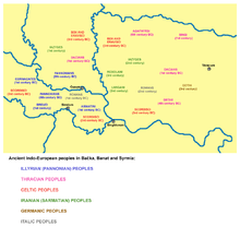
Ancient Indo-European peoples in Banat
-
Ancient Roman cities in Banat
Migration Period and Early Middle Ages
The Goths were forced out by the Huns, who organized their ruling center in the Pannonian Basin (the Pannonian Plain), an area that included the northwestern part of today's Banat. After the death of Attila, the Hunnic empire disintegrated in days. The previously subjected Gepids formed a new kingdom in the area, only to be defeated 100 years later by the Avars.
One governing center of the Avars was formed in the region, which played an important role in the Avar–Byzantine wars. An inscription on one of the vessels from the Treasure of Sânnicolau Mare (which is presumably of Avar origin) recorded names of two local rulers, Butaul and Buyla, who bore Slavic ruling titles of župan. The Avar rule over the area lasted until the 9th century, until Charlemagne's campaigns. The Banat region became part of the First Bulgarian Empire a few decades later. Archaeological evidence shows the Avars and Gepids lived here until the middle of the 10th century. The Avar rule had triggered considerable Slavic migration to the southern Pannonian plain and to the Balkans.
In 895, the Hungarians living in Etelköz entered the Byzantine-Bulgarian war as allies of Byzantium, and defeated the Bulgars. Because of this, the Bulgarians allied with the Pechenegs, who attacked the Hungarian settlements. This led to the process of what is known as the Hungarian conquest of the Pannonian basin, referred to by them as "hometaking" (honfoglalás) in Hungarian. This also resulted in the loss of part of the territories north of the Danube for the Bulgarian empire.
Hungarian administration (early 10th century - 16th century)

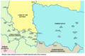
Banat was administered by the Kingdom of Hungary from the 10th century up until 1552, when the region of Temesvár was taken by the Ottoman Empire. Before the Hungarian conquest, according to Gesta Hungarorum chronicle, a local Bulgarian ruler known as Glad ruled over the Banat.
The area of the Timiș river was not the land of the Hungarian royal tribe. From the middle of the 10th century, when royal rule began weakening, the local Slavic-Bulgarian tribes began to pursue a more independent foreign policy. As a consequence, in the eastern part of the Pannonian basin among Christians, the Byzantine rite became more influential. This was halted with the establishment of the Kingdom of Hungary. István I reasserted dominance over the last local leader, Ahtum (Ajtony in other sources). Ahtum was a semi-independent ruler of Banat and an Orthodox Christian.
In 1233, under the Kingdom of Hungary administration, the Banat of Severin was formed, including eastern parts of the modern Banat. In the 14th century, the region became of priority concern to the Kingdom, as the southern border of the Banat was the most important defensive line against Ottoman expansion from the Southeast.
-
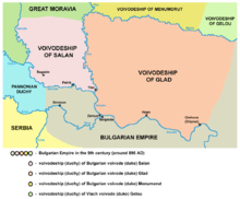
Duchy of Glad, 9th century
-

Duchy of Ahtum, 11th century
-

Banate of Severin
Ottoman administration (1552–1716)

The Ottoman Empire took over the area and incorporated the Banat in 1552. It was absorbed as an Ottoman eyalet (province) named the Eyalet of Temeşvar. The Banat region was mainly populated by Rascians (Serbs) in the west and Vlachs (Romanians) in the east; thus, in some historical sources it was referred to as Rascia and in others Wallachia. Numerous Ottoman Muslims settled in the area, living mostly in the cities and associated with trade and administration. In 1594, Serbs in Banat started a large uprising against Ottoman rule. The Romanians also participated in this uprising.
For a short time, in the 16th century, an administrative unit of vassal Ottoman principality of Transylvania, known as the Banate of Lugos and Karansebes, operated in this area.
-

Eyalet of Temeşvar and Banate of Lugos and Karansebes in 1568
-
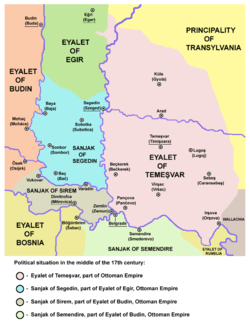
Eyalet of Temeşvar in the middle of the 17th century
-

Eyalet of Temeşvar in 1699
Habsburg administration (1716–1918)
In the 17th century, northern parts of the Eyalet of Temeşvar were incorporated into the Habsburg Monarchy of Austria, but the Banat remained under Ottoman administration. In 1716, Prince Eugene of Savoy took the Banat region from the Ottomans. It was renamed as the Banat of Temeswar after the Treaty of Passarowitz (1718). It was a separate province within the Habsburg Monarchy and under military administration until 1751, when Empress Maria Theresa of Austria introduced a civil administration. The Banat of Temeswar province was abolished in 1778. The southern part of the Banat region remained within the Military Frontier (Banat Krajina) until the Frontier was abolished in 1871.

During the Ottoman rule, parts of Banat had a low population density due to years of warfare, and some local residents also lost their lives during Habsburg-Ottoman wars and Prince Eugene of Savoy's conquest. Much of the area had reverted to nearly uninhabited marsh, heath and forest. Count Claudius Mercy (1666–1734), who was appointed governor of the Banat of Temeswar in 1720, took numerous measures for the regeneration of the Banat. He recruited German artisans and especially farmers from Bavaria and other southern areas as colonists, allowing them privileges such as keeping their language and religion in their settlements. Farmers brought their families and belongings on rafts down the Danube River, and were encouraged to restore farming in the area. They cleared the marshes near the Danube and Tisa rivers, helped build roads and canals, and re-established agriculture. Trade was also encouraged.[1]
Maria Theresa also took a direct interest in the Banat; she colonized the region with large numbers of German farmers, who were admired for their agricultural skills. She encouraged the exploitation of the mineral wealth of the country, and generally developed the measures that were introduced by Count Mercy.[1] German settlers arrived from Swabia, Alsace and Bavaria, as did German-speaking colonists from Austria. Many settlements in the eastern Banat were developed by Germans and had ethnic-German majorities. The ethnic Germans in the Banat region became known as the Danube Swabians, or Donauschwaben. After years of separation from their original German provinces, their language was markedly different, preserving historic characteristics.
Similarly, a minority coming from French-speaking or linguistically mixed communes in Lorraine maintained the French language for several generations, and developed a specific ethnic identity, later known as Banat French, Français du Banat.[2]
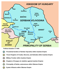
In 1779, the Banat region was incorporated into the Habsburg Kingdom of Hungary, and the three counties of Torontal, Temes and Karasch were created. In 1848, after the May Assembly, the western Banat became part of the Serbian Vojvodina, a Serbian autonomous region within the Habsburg Monarchy. During the Revolutions of 1848–1849, the Banat was respectively held by Serbian and Hungarian troops.
After the Revolution of 1848–1849, the Banat (together with Syrmia and Bačka) was designated as a separate Austrian crownland known as the Voivodeship of Serbia and Banat of Temeschwar. In 1860 this province was abolished and most of its territory was incorporated into the Habsburg Kingdom of Hungary.
After 1871, the former Military Frontier, located in southern parts of the Banat, came under civil administration and was incorporated into the Banat counties. Krassó and Szörény were united into Krassó-Szörény in 1881.
-

Banat of Temeswar, province of the Habsburg Monarchy in 1739
-

Voivodeship of Serbia and Banat of Temeschwar (1849-1860)
-
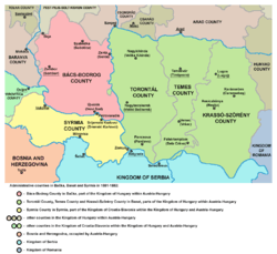
Counties in Banat, Bačka and Srem after 1881, the five counties, which were formed in the territory of former Voivodeship of Serbia and Banat of Temeschwar
After 1918

In 1918, the Banat Republic was proclaimed in Timișoara in October, and the government of Hungary recognized its independence. However, it was short-lived. After just two weeks, Serbian troops invaded the region and took control. From November 1918 to March 1919, western and central parts of Banat were governed by Serbian administration from Novi Sad, as part of the Banat, Bačka and Baranja province of the Kingdom of Serbia and newly formed Kingdom of Serbs, Croats and Slovenes (which was later renamed as Yugoslavia).
In the wake of the Declaration of Union of Transylvania with Romania on December 1, 1918 and the Declaration of Unification of Banat, Bačka and Baranja with Serbia on November 25, 1918, most of the Banat was (in 1919) divided between Romania (Krassó-Szörény completely, two-thirds of Temes, and a small part of Torontál) and the Kingdom of Serbs, Croats and Slovenes (most of Torontál, and one-third of Temes). A small area near Szeged was assigned to the newly independent Hungary. These borders were confirmed by the 1919 Treaty of Versailles and the 1920 Treaty of Trianon.
At the dissolution of Austria-Hungary, the delegates of the Romanian and some German communities voted for union with Romania;[3][4] the delegates of the Serbian, Bunjevac and other Slavic and non-Slavic communities (including some Germans) voted for union with Serbia; while the Hungarian minority remained loyal to the government in Budapest. Besides these declarations, no other plebiscite was held.
During World War II, the Axis Powers occupied this area and partitioned it. Nazi Germany had been intent on expanding into eastern Europe to incorporate what it called the Volksdeutsche, people of ethnic German descent. They established the political entity known as Banat in 1941. It included only the western part of the historical Banat region, which was formerly part of Yugoslavia. It was formally under the control of the Serbian puppet Government of National Salvation in Belgrade led by Milan Nedić. It theoretically had limited jurisdiction over all of the territory under German Military Administration in Serbia, but in practice the local minority of ethnic Germans (Danube Swabians or Shwoveh) held the political power within the Banat. The regional civilian commissioner was Josef Lapp. The head of the ethnic German group was Sepp Janko. Following the ousting of Axis forces in 1944, this German-ruled region was dissolved. Most of its territory was included in the Vojvodina, one of the two autonomous provinces of Serbia within the new SFR Yugoslavia. Following WWII, most ethnic Germans were expelled from the Banat and eastern Europe.
The territory of the Banat is presently part of the Romanian counties Timiș, Caraș-Severin, Arad and Mehedinți; the Serbian autonomous province of Vojvodina and Belgrade City District; and the Hungarian Csongrád County.
-

Banat Republic in 1918
-

Division of Banat in 1919-1923
Map

Geography
Romanian Banat


In 1938, the counties of Timiș-Torontal, Caraș, Severin, Arad and Hunedoara were joined to form ținutul Timiș, which roughly encompassed the area typically called Banat in Romania.
On 6 September 1950, the province was replaced by the Timișoara Region (formed by the present-day counties of Timiș and Caraș-Severin).
In 1956, the southern half of the existing Arad Region was incorporated to the Timișoara Region.
In December 1960, the Timișoara Region was named the Banat Region.
On 17 February 1968, a new territorial division was made and today's Timiș, Caraș-Severin and Arad counties were formed.
Since 1998, Romania has been split into eight development regions, which act as autonomous territorial divisions. The Vest development region is composed of four counties: Arad, Timiș, Hunedoara and Caraș-Severin; thus it has almost same borders as the Timiș Province (ținutul Timiș) of 1938. The Vest development region is also a part of the Danube-Criș-Mureș-Tisa Euroregion. Ethnic minorities in the region are including Hungarians (5.6% of the population), Serbs, Croats (Krashovans), Bulgarians, Ukrainians, and others.
The Romanian Banat is mountainous in the south and southeast, while in the north, west and south-west it is flat and in some places marshy. The climate, except in the marshy parts, is generally healthy. Wheat, barley, oats, rye, maize, flax, hemp and tobacco are grown in large quantities, and the products of the vineyards are of a good quality. Game is plentiful and the rivers swarm with fish. The mineral wealth is great, including copper, tin, lead, zinc, iron and especially coal. Amongst its numerous mineral springs, the most important are those of Mehadia, with sulphurous waters, which were already known in the Roman period as the Termae Herculis (Băile Herculane). The present "Banat Region" of Romania includes some areas that are mountainous and were not part of the historical Banat or of the Pannonian plain.
Serbian Banat
The Serbian Banat (Western Banat) was part of Serbian Vojvodina (1848–1849) and part of the Voivodeship of Serbia and Banat of Temeschwar (1849–1860). After 1860, the Serbian Banat was part of Torontal and Temes counties of Habsburg Kingdom of Hungary. The center of Torontal county was Veliki Bečkerek, the current Zrenjanin.
The region was county of the Kingdom of Serbs, Croats and Slovenes between 1918 and 1922 (in 1918–1919, county was part of the province of Banat, Bačka and Baranja) and from 1922 to 1929 it was divided between Belgrade oblast and Podunavlje oblast. In 1929, most of the region was incorporated into the Danube Banovina (Danubian Banat), a province of the Kingdom of Yugoslavia, while the city of Pančevo was incorporated into self-governed Belgrade district.
Between 1941 and 1944, the Serbian Banat was occupied by the Nazi German troops. Following the Axis partition of Yugoslavia, Serbian Banat was made a part of German-occupied Serbia, in which it enjoyed autonomy. It functioned as a virtually separate autonomous entity ruled by its German minority, who were promoted by the German occupational military authorities. During this time, numerous war crimes were committed against local Serb and Jewish population. As a consequence of a disturbed ethnic relations during the occupation, much of the local Germans fled from the region together with defeated German army in 1944. Those Germans who remained in the country were sent to prison camps run by the new communist authorities. After prison camps were dissolved (in 1948), most of the remaining German population left Serbia because of economic reasons. Many went to Germany; others emigrated to western Europe and the United States.
Since 1944-1945, the Serbian Banat (together with Bačka and Syrmia), has been part of the Serbian Autonomous Province of Vojvodina, first as part of the Socialist Federal Republic of Yugoslavia and then as part of the Federal Republic of Yugoslavia and Serbia and Montenegro. Since 2006, it has been part of an independent Serbia.
In Serbia, the Banat is mostly plains. Wheat, barley, oats, rye, maize, hemp and sunflower are grown, and mineral wealth consists of oil and natural gas. A popular tourist destination in the Banat is Deliblatska Peščara. There are also several ethnic minorities in the region, including Hungarians (10.21% of the population), Romanians, Slovaks, Bulgarians, Macedonians, Roma people, and others.
The districts of Serbia in Banat are:
- North Banat okrug (which also includes municipalities of Ada, Senta and Kanjiža, which are situated in the region of Bačka)
- Central Banat okrug
- South Banat okrug
Serbian Banat also includes the area known as Pančevački Rit, which belongs to the Belgrade municipality of Palilula.
See also: Geographical regions in Serbia
Hungarian Banat
The Hungarian Banat consists of a small northern part of the region, which is part of the Csongrád County of Hungary. In addition to the Hungarian population, there's a small minority of Serbs (e.g. in Deszk, Szőreg).
Demographics
The Whole Banat
1660–1666
In 1660–1666, Serbs lived in western (flat) part of the Banat, while Romanians lived in the eastern (mountainous) part.[5]
1743–1753
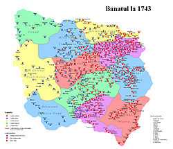
In 1743–1753, ethnic composition of Banat looked as follows:[6]
- Three eastern districts had a Romanian population: Lugoj, Caransebeș and Orșova.
- Three western districts had a Serbian population: Veliki Bečkerek, Pančevo and Velika Kikinda.
- Six central districts had a mixed Serb-Romanian population: Timișoara, Lipova, Vršac, Nova Palanka, Ciacova and Cenad.
Ethnic Hungarians were almost totally absent from the region in the first half of the 18th century.[7] They were considered politically unreliable, but in 1730 some Catholic Hungarians were allowed to settle down in the Banat.[8]
1774
According to 1774 data, the population of the Banat of Temeswar numbered 375,740 people and was composed of:[9]
- 220,000 (58.55%) Romanians
- 100,000 (26.61%) Serbs and Greeks
- 53,000 (14.11%) Germans
- 2,400 (0.64%) Hungarians and Bulgarians
- 340 (0.09%) Jews
1840
Banat had in 1840 a population of over a million which included:[8]
- 570,000 Romanians
- 200,000 Germans
- 200,000 Serbs
- 60,000 Hungarians
1900


In 1900, the population of Banat numbered 1,431,329 people, including:[10]
- 578,789 (40.4%) Romanians
- 362,487 (25.3%) Germans
- 251,938 (17.6%) Serbs
- 170,124 (11.9%) Hungarians
1910
According to the 1910 census, the population of the Banat region (counties of Torontál, Temes and Krassó-Szörény) numbered 1,582,133 people, including:[11][12][13] (*)
- 592,049 (37.42%) Romanians
- 387,545 (24.50%) Germans
- 284,329 (17.97%) Serbs
- 242,152 (15.31%) Hungarians
- smaller numbers of other ethnic groups such as the Czechs, Slovaks, Croats, Rusyns, Ukrainians, Bulgarians, etc.
(*) Note: according to the 1910 census, the population of Romanian Banat included 52.6% Romanians, 25.6% Germans, 12.2% Hungarians, and 4.9% Serbs, while population of Serbian Banat included 40.53% Serbs, 22.14% Germans, 19.18% Hungarians, 12.94% Romanians, and 2.86% Slovaks. In Serbia the majority of the Banat Swabian or Shwovish population fled from the region together with the defeated German army in the Fall of 1944, as one can see in the population Table below, where the German - speaking Shwovish population dropped from about 120,000 in 1931 to about 17,000 in 1948. Those who remained in the country were sent to prison camps run by the new communist authorities, where many died from hunger, disease and cold, but many also escaped. After the prison camps were dissolved (in 1948), most of the remaining German population left Serbia and Yugoslavia because of economic reasons. Their flight was mainly a consequence of wartime events and Axis occupation of Yugoslavia, but partly also a consequence of the economic situation in the post-war years. In Romania ethnic Germans mostly emigrated after 1989 for economic reasons.
Population table
The historical population of the Banat region in different time periods:
| Year | Total |
|---|---|
| 1717 | 85,166 |
| 1743 | 125,000 |
| 1753 | 210,992 |
| 1774 | 375,740 |
| 1797 | 667,912 |
| 1900 | 1,431,329 |
| 1910 | 1,582,133 |
Romanian Banat
The historical population of the Romanian Banat (the Timiș,[14][15] and Caraș-Severin,[16][17] counties) was as following:
| Year | Total | Romanians | Hungarians | Germans | Serbs | Roma |
|---|---|---|---|---|---|---|
| 1880 | 744,367 | 426,368 (57.3%) | 37,586 (5.0%) | 202,698 (27.2%) | 46,983 (6.3%) | n/a |
| 1890 | 812,799 | 446,816 (55.0%) | 50,899 (6.3%) | 233,006 (29.9%) | 41,356 (5.1%) | n/a |
| 1900 | 871,598 | 468,508 (53.8%) | 78,656 (9.0%) | 243,582 (27.9%) | 41,960 (4.8%) | n/a |
| 1910 | 902,210 | 474,787 (52.6%) | 109,873 (12.2%) | 231,391 (25.6%) | 44,598 (4.9%) | n/a |
| 1920 | 822,639 | 450,817 (54.8%) | 79,955 (9.7%) | 208,774 (25.4%) | n/a | n/a |
| 1930 | 878,877 | 473,781 (53.9%) | 91,421 (10.4%) | 215,031 (24.5%) | 37,113 (4.2%) | 16,471 (1.9%) |
| 1941 | 898,262 | 505,448 (56.3%) | 80,575 (9.0%) | 213,840 (23.8%) | n/a | n/a |
| 1956 | 896,668 | 589,369 (65.7%) | 85,790 (9.6%) | 137,697 (15.4%) | 40,018 (4.5%) | 9,309 (1.0%) |
| 1966 | 966,322 | 674,062 (69.8%) | 85,358 (8.8%) | 133,197 (13.8%) | 38,535 (4.0%) | 6,769 (0.7%) |
| 1977 | 1,082,461 | 796,007 (73.5%) | 86,763 (8.0%) | 119,972 (11.1%) | 29,514 (2.7%) | 15,755 (1.5%) |
| 1992 | 1,076,380 | 886,958 (82.4%) | 70,742 (6.6%) | 38,658 (3.6%) | 25,029 (2.3%) | 22,612 (2.1%) |
| 2002 | 1,011,145 | 859,690 (85.0%) | 56,380 (5.6%) | 20,323 (2.0%) | 19,355 (1.9%) | 23,998 (2.4%) |
Serbian Banat
| Year | Total | Serbs | Hungarians | Germans | Romanians | Slovaks |
|---|---|---|---|---|---|---|
| 1910 | 566,400 | 229,568 (40.5%) | 108,622 (19.2%) | 125,374 (22.1%) | 73,303 (12.9%) | 16,223 (2,9%) |
| 1921 | 559,096 | 235,148 (42.1%) | 98,463 (17.6%) | 126,519 (22.6%) | 66,433 (11,9%) | 17,595 (3,2%) |
| 1931 | 585,579 | 261,123 (44,6%) | 95,867 (16,4%) | 120,541 (20,6%) | 62,365 (10,7%) | 17,900 (2,1%) |
| 1948 | 601,626 | 358,067 (59,6%) | 110,446 (18,4%) | 17,522 (2,9%) | 55,678 (9,3%) | 20,685 (2,4%) |
| 1953 | 617,163 | 374,258 (60,6%) | 112,683 (18,4%) | n/a | 55,094 (8,9%) | 21,299 (3,4%) |
| 1961 | 655,868 | 423,837 (64,6%) | 111,944 (17,1%) | n/a | 54,447 (8,3%) | 22,306 (3,4%) |
| 1971 | 666,559 | 434,810 (65,2%) | 103,090 (15.5%) | n/a | 49,455 (7,4%) | 22,173 (3,3%) |
| 1981 | 672,884 | 424,765 (65,7%) | 90,445 (14,0%) | n/a | 43,474 (6,7%) | 21,392 (3,3%) |
| 1991 | 648,390 | 423,475 (65,1%) | 76,153 (11.7%) | n/a | 35,935 (5,5%) | 19,903 (3.1%) |
| 2002 | 665,397 | 477,890 (71.8%) | 63,047 (9.5%) | 908 (0,1%) | 27,661 (4,1%) | 17,994 (2,7%) |
Symbols
The traditional heraldic symbol of the Banat is a lion, which is nowadays present in both the coat of arms of Romania and the coat of arms of Vojvodina.
Cities
The largest cities in the Banat are:
- Romania:
- Timișoara (319,279)
- Reșița (73,282)
- Lugoj (37,700)
- Caransebeș (28,301)
- Serbia (Vojvodina):
- Serbia (Belgrade City District):
- Borča (46,086)
Gallery


See also
- Vojvodina
- Banat Krajina
- Banat Bulgarians
- Banat Swabians
- Danube Swabians
- Treaty of Karlowitz
- Military Frontier
References
- Dušan Belča, Mala istorija Vršca, Vršac, 1997.
- Milojko Brusin, Naša razgraničenja sa susedima 1919–1920, Novi Sad, 1998.
- Branislav Bukurov, Bačka, Banat i Srem, Novi Sad, 1978.
- Miodrag Milin, Vekovima zajedno (Iz istorije srpsko-rumunskih odnosa), Temišvar, 1995.
- Jovan M. Pejin, Iz prošlosti Kikinde, Kikinda, 2000.
- Milan Tutorov, Mala Raška a u Banatu, istorika Zrenjanina i Banata, Zrenjanin, 1991.
- Milan Tutorov, Banatska rapsodija, istorika Zrenjanina i Banata, Novi Sad, 2001.
- Josef Wolf, Entwicklung der ethnischen Struktur des Banats 1890–1992 (Atlas Ost- und Südosteuropa / Hrsg.: Österreichisches Ost- und Südosteuropa-Institut; 2: Bevölkerung; 8 = H/R/YU 1, Ungarn/Rumänien/Jugoslawien), Berlin – Stuttgart, 2004.
- Tiberiu Schatteles, EVREII DIN TIMISOARA IN PERSPECTIVA ISTORICA Editura "HASEFER" Bucuresti, 2013
Notes
- ↑ 1.0 1.1
 Chisholm, Hugh, ed. (1911). "Banat". Encyclopædia Britannica (11th ed.). Cambridge University Press.
 - ↑ Smaranda Vultur, De l’Ouest à l’Est et de l’Est à l’Ouest : les avatars identitaires des Français du Banat, Texte presenté a la conférence d'histoire orale: Visibles mais pas nombreuses : les circulations migratoires roumaines, Paris, 2001
- ↑ http://www.cimec.ro/Istorie/Unire/rezo_eng.htm
- ↑ http://www.caransebes.ro/istorie/istoric/istoria_en.htm
- ↑ Dr. Dušan J. Popović, Srbi u Vojvodini, knjiga 2, Novi Sad, 1990.
- ↑ Dr. Dušan J. Popović (see above)
- ↑ Ethnic Geography of the Hungarian Minorities in the Carpathian Basin - By Károly Kocsis, Eszter Kocsisné Hodosi, page 140.
- ↑ 8.0 8.1 Judy Batt, Kataryna Wolczuk. Region State and Identity in Central and Eastern Europe
- ↑ Miodrag Milin, Vekovima zajedno (iz istorije srpsko-rumunskih odnosa), Temišvar, 1995.
- ↑ Banatul.com - History and Information about Banat, Serbia and Banat, Romania
- ↑ Torontál County
- ↑ Temes County
- ↑ Krassó-Szörény County
- ↑ Ethnic composition of the Timiș County (1850-1992)
- ↑ Recensământ 2002, Census 2002: Timiș County
- ↑ Ethnic composition of the Caraș-Severin County (1850-1992)
- ↑ Recensământ 2002, Census 2002: Caraș-Severin County
External links
| Wikimedia Commons has media related to Banat. |
- Banat Social Networking Web Site
- banatul.com (English) / (Romanian)
- backabanat.com (Serbian)
- Development of Ethnic Structure in the Banat 1890 - 1992
- regions Banat (English) / (Romanian) / (French) /(German)
- Návštěva Svaté Heleny, reportáž z expedice Roadtrip 2007 - návštěva Banátu (Svaté Heleny) (Czech)
- Smaranda Vultur, De l’Ouest à l’Est et de l’Est à l’Ouest : les avatars identitaires des Français du Banat (French)
- Remembering Molidorf (English) / (Romanian) / (French) /(German)
- Family Books of the Banat (English) / (Romanian) / (French) /(German)
- Danube Swabian Resources (English) / (Romanian) /(German)
- Donauschwaben Villages Helping Hands Nonprofit (English)
- Danube Swabians in Banat (English)
- Stanko Trifunović (1997). "Slovenska naselja V-VIII veka u Bačkoj i Banatu". Novi Sad: Muzej Vojvodine.
| |||||||||||||||||||||||||||||

| ||||||||

| |||||||||||||||||||||||||||||||||
