Ban Na San District
| Ban Na San บ้านนาสาร | |
|---|---|
| Amphoe | |
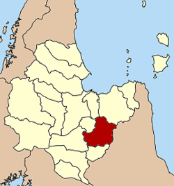 Amphoe location in Surat Thani Province | |
| Coordinates: 8°48′2″N 99°21′51″E / 8.80056°N 99.36417°ECoordinates: 8°48′2″N 99°21′51″E / 8.80056°N 99.36417°E | |
| Country |
|
| Province | Surat Thani |
| Seat | Na San |
| Area | |
| • Total | 839.3 km2 (324.1 sq mi) |
| Population (2005) | |
| • Total | 68,345 |
| • Density | 81.4/km2 (211/sq mi) |
| Time zone | THA (UTC+7) |
| Postal code | 84120 |
| Geocode | 8412 |
Ban Na San (Thai: บ้านนาสาร) is a district (amphoe) of Surat Thani Province, Thailand.
Geography
Neighboring districts are (from the east clockwise) Nopphitam and Phipun of Nakhon Si Thammarat Province, Wiang Sa, Khian Sa, Ban Na Doem, Mueang Surat Thani and Kanchanadit.
The east of the district is located within the hills of the Nakhon Si Thammarat mountain range and is part of the Tai Rom Yen National Park.
History
The district dates back to the Lamphun district, once responsible for all of the southeastern part of the present-day province. Originally the district was subdivided into 7 tambon - Ban Na, Tha Ruea, Kobkaeb, Thung Tao, I-Pan, Prasaeng and Phanom. In 1899 the southern part was split of as Prasaeng district and Phanom minor district.
Originally the district was administrated from Nakhon Si Thammarat, and was transferred to Chaiya (now Surat Thani) in 1906.[1]
On April 29, 1918 the district was renamed to Ban Na, the location of the district office. On July 1, 1938 the district office was moved to Na San[2] and the district was renamed on April 20, 1939 to Ban Na San.[3] In the 1970s the district was reduced in size when the districts of Khian Sa, Wiang Sa and Ban Na Doem were split off.
Administration
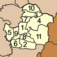
Ban Na San is subdivided into 11 subdistricts (tambon), which are further subdivided into 65 villages (muban). There is one town (thesaban mueang) Na San, which covers the complete tambon Na San. Each tambon except Na San has a Tambon administrative organization (TAO).
|
 |
References
- ↑ แจ้งความกระทรวงมหาดไทย: เรื่อง โอนท้องที่อำเภอลำพูน ๑ อำเภอพนม๑ อำเภอพะแสง๑ รวมสามอำเภอจากเขตเมืองนครศรีธรรมราชมาขึ้นเมืองไชยา มณฑลชุมพร. Royal Gazette (in Thai) 23 (18): 408–409. July 29, 1906.
- ↑ ประกาศกระทรวงมหาดไทย เรื่อง ย้ายที่ว่าการอำเภอบ้านนา จังหวัดสุราษฎร์ธานี. Royal Gazette (in Thai) 55 (0 ง): 4314. 1939-03-27.
- ↑ พระราชกฤษฎีกาเปลี่ยนนามอำเภอ กิ่งอำเภอ และตำบลบางแห่ง พุทธศักราช ๒๔๘๒. Royal Gazette (in Thai) 56 (0 ก): 354–364. April 17, 1939.
External links
- amphoe.com (Thai)
- http://www.nasancity.org (Thai)