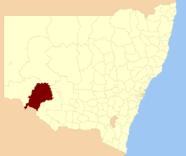
Balranald Shire
Balranald Shire is a local government area in the Riverina area of western New South Wales, Australia on the Sturt Highway. It is the location of World Heritage listed Mungo National Park. It includes the towns of Balranald and Euston. Other localities in the Shire include Kyalite, Hatfield, Penarie, Clare and Oxley.
The Mayor of Balranald Shire Council is yet to be determined, following the 2012 local government election.
Council
Current composition and election method
Balranald Shire Council is composed of eight councillors elected proportionally as a single ward. All councillors are elected for a fixed four-year term of office. The mayor is elected by the councillors at the first meeting of the Council. The most recent election was held on 8 September 2012, and the makeup of the council is as follows:[2]
| Party | Councillors |
| |
Independents and Unaligned |
8 |
|
Total |
8 |
The current Council, elected in 2012, in order of election, is:[2]
| Councillor | Party | Notes |
| |
Steve O'Halloran |
Independent |
|
| |
Leigh Byron |
Unaligned |
|
| |
Trevor Jolliffe |
Independent |
|
| |
Jeff Mannix |
Independent |
|
| |
Alan Purtill |
Unaligned |
|
| |
Lynda Cooke |
Independent |
|
| |
Ken Barnes |
Independent |
|
| |
Elaine Campbell |
Independent |
|
References
|
|---|
| | Metropolitan Sydney | Inner Sydney | |
|---|
| Outer Sydney | |
|---|
| Sydney Surrounds | |
|---|
|
|---|
| | Mid North Coast | |
|---|
| | Murray | |
|---|
| | Murrumbidgee | |
|---|
| | Hunter | |
|---|
| | Illawarra | |
|---|
| | Richmond Tweed | |
|---|
| | Southeastern | |
|---|
| | Northern | |
|---|
| | Central West | |
|---|
| | North Western | |
|---|
| | Far West | |
|---|
|

