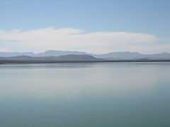
Balmorhea Lake
| Balmorhea Lake | |
|---|---|
 | |
| Location | Reeves County, Texas |
| Coordinates | 30°57.77′N 103°43.25′W / 30.96283°N 103.72083°WCoordinates: 30°57.77′N 103°43.25′W / 30.96283°N 103.72083°W |
| Type | Irrigation reservoir |
| Primary inflows | Sandia Creek, Toyah Creek |
| Primary outflows | Sandia Creek |
| Basin countries | United States |
| Surface area | 556 acres (225 ha) |
| Max. depth | 25 ft (7.6 m) |
| Water volume | 6,350 acre·ft (0.00783 km3) |
| Surface elevation | 3,187 ft (971 m) |
Balmorhea Lake is a reservoir on Sandia Creek 2 miles (3 km) southeast of downtown Balmorhea, Texas. Water from Toyah Creek, fed by the nearby San Solomon Springs, is also fed into the reservoir, as is excess water in the Phantom Lake Canal. The reservoir was built in 1917 by the construction of a dam by the Reeves County Water Improvement District. The reservoir provides water for irrigation, and is a popular recreational spot for locals.
Balmorhea Lake is also known as Lower Parks Reservoir.
Fish and plant life
Balmorhea Lake has been stocked with species of fish intended to improve the utility of the reservoir for recreational fishing. Fish present in Balmorhea Lake include sunfish, crappie, catfish, and largemouth bass.
Recreational uses
Balmorhea Lake is used for swimming and fishing.
External links
- Balmorhea Lake - Texas Parks & Wildlife
- Balmorhea Lake from the Handbook of Texas Online