Balmhorn
| Balmhorn | |
|---|---|
|
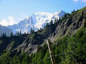
View of the Balmhorn from Allmenalp, above Kandersteg | |
| Elevation | 3,698 m (12,133 ft) |
| Prominence | 1,022 m (3,353 ft)[1] |
| Isolation | 12.3 km (7.6 mi)[2] |
| Parent peak | Finsteraarhorn |
| Location | |
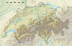
 Balmhorn Location in Switzerland | |
| Location | Berne/Valais, Switzerland |
| Range | Bernese Alps |
| Coordinates | 46°25′30″N 7°41′37″E / 46.42500°N 7.69361°ECoordinates: 46°25′30″N 7°41′37″E / 46.42500°N 7.69361°E |
| Climbing | |
| First ascent | 21 July 1864 by Frank Walker, Horace Walker and Lucy Walker, with guides Jakob Anderegg and Melchior Anderegg |
| Easiest route | South-west ridge (Zackengrat) |
The Balmhorn (3,698 m) is a mountain in the Bernese Alps in Switzerland. Its summit ridge lies on the border between the cantons of Berne and the Valais.
It was first climbed by Frank Walker, Horace Walker and Lucy Walker, with guides Jakob Anderegg and Melchior Anderegg on 21 July 1864.[3]

The southern flanks of the Rinderhorn and Balmhorn seen from the Ferdenrothorn
Huts
- Balmhornhütte
- Lötschenpass Hut 1
- Lötschenpass Hut 2
- Berghotel Schwarenbach
See also
- List of mountains of Switzerland
- List of mountains of the canton of Bern
- List of mountains of Valais
- List of most isolated mountains of Switzerland
References
- ↑ Retrieved from the Swisstopo topographic maps. The key col is the Lötschen Pass (2,676 m).
- ↑ Retrieved from Google Earth. The nearest point of higher elevation is west of the Bietschhorn.
- ↑ The Balmhorn on SummitPost
