Ballyduff, County Waterford
| Ballyduff Baile Dubh | |
|---|---|
| Village | |
 | |
 Ballyduff Location in Ireland | |
| Coordinates: 52°08′52″N 8°03′11″W / 52.14791°N 8.05309°WCoordinates: 52°08′52″N 8°03′11″W / 52.14791°N 8.05309°W | |
| Country |
|
| Province | Munster |
| County | County Waterford |
| Time zone | WET (UTC+0) |
| • Summer (DST) | IST (WEST) (UTC-1) |
Ballyduff (Irish: Baile Dubh, meaning "black village") is a village in County Waterford, Ireland.[1] It is also a parish in the Roman Catholic Diocese of Waterford and Lismore.
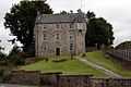
Historical maps mark the location of Ballyduff Castle in ruins. It was built in 1627 by the carpenter Andrew Tucker for the Earl of Cork. The Drew family gained possession of it later in the 17th century.[2]
Location and access
Ballyduff is a town on the Blackwater River in County Waterford, Ireland.[3] It has a bridge over the river. It is 6 miles west of Lismore and 10 east of Fermoy, Co. Cork.
Facilities
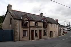
Ballyduff has: a parish hall (old school hall) and a National School[4] with a new hall. It has a Roman Catholic church.
Sport
Gallery
-
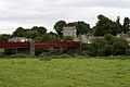
Bridge over Blackwater River
-
Garda Station
References
- ↑ "Placenames Database of Ireland". Dublin City University. Retrieved 13 January 2015.
- ↑ "Archaeological Survey Database SMR WA020-011". National Monuments Service. Retrieved 14 January 2015.
- ↑ "Map Viewer". Ordnance Survey Ireland. Retrieved 13 January 2015.
- ↑ "St. Michael’s Ballyduff National School" (PDF). Department of Education and Skills. Retrieved 13 January 2015.